Mountainous precipitation measurement and calculation method suitable for south-eastern Tibetan plateau area and application
A mountain and regional technology, applied in the field of precipitation measurement in high-altitude mountainous areas, can solve the problems of inability to obtain precipitation data, lack of meteorological observation stations, etc., and achieve the effect of scientific and simple calculation process and reliable principle.
- Summary
- Abstract
- Description
- Claims
- Application Information
AI Technical Summary
Problems solved by technology
Method used
Image
Examples
Embodiment 1
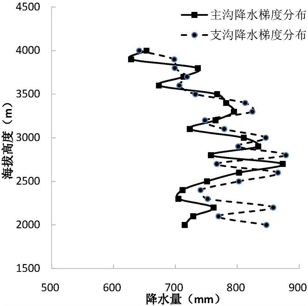
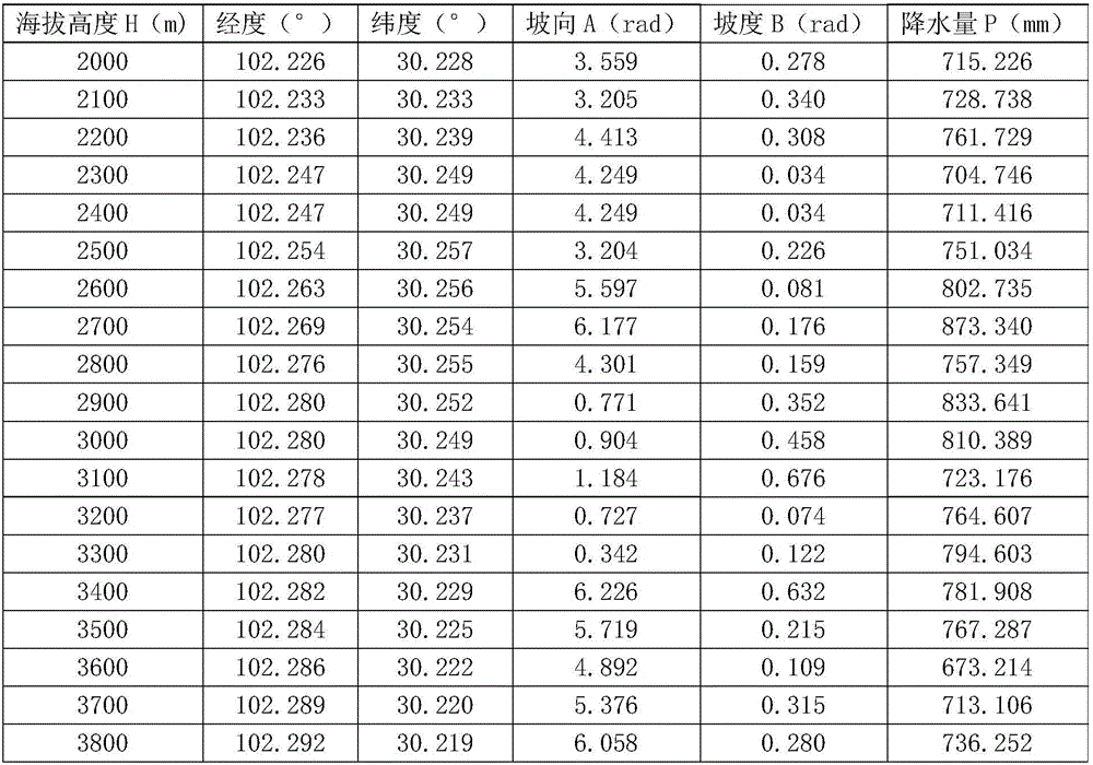
[0032] Such as figure 1 shown. Jiangzui Ditch is located on the left bank of the Dadu River. The ditch mouth is 5km away from the Huangjinping Hydropower Station of the Dadu River. It is under the jurisdiction of Kangding County, Ganzi Prefecture, Sichuan. The source of Jiangzui Gully is about 3800m above sea level, the gully mouth is about 1420m above sea level, and the main ditch is about 19.37km long. The main ditch of Jiangzui Ditch is Guada Ditch. The ditch in its watershed is relatively tortuous, and the flow direction of the main ditch changes greatly. It turns from southeast to nearly east-west near Xiahuodi, and after a certain distance, it turns to south-west. to flow into the Dadu River. The clear water confluence area is 3800m-2800m, the provenance area is 2800-1800m, and below 1800m is the circulation area and accumulation area. The vegetation is developed from the two river mouths to the ditch source in the upper reaches of Maiben Township. Mozigou, a branch d...
Embodiment 2
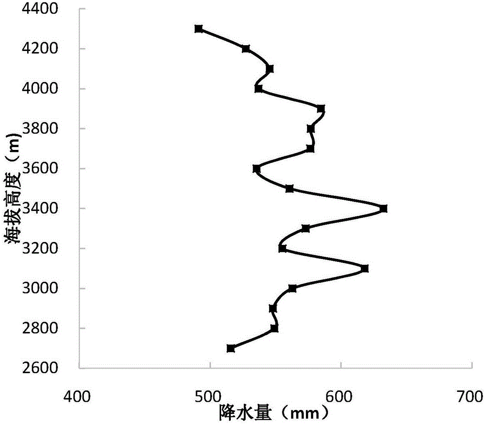
[0047] Such as figure 2 shown. Lawagou is a grade I tributary on the left bank of the Jinsha River. The coordinates of the mouth of the ditch are 30°5′2.24″N, 99°2′40.09″E. The watershed generally flows in the direction of EW, and flows into the Jinsha River at an angle of 73°. The length of the main ditch is 8.13km, and the drainage area is 27.77km 2 . The upper reaches of the entire watershed have relatively gentle terrain slopes, while the middle and lower reaches have relatively steep topography, especially the steep topography on the left bank of the lower reaches of the channel, which provides favorable conditions for the development of collapses and the like. The elevation of the source of Lawagou is 4374m, which belongs to the local level II planation plane (4200-4400m above sea level), and the elevation of the mouth of the valley is 2532m. Below 2800m in the valley is dry and hot valley shrub, 2800-3100m is mountain thin-leaf shrub, and then gradually enters cold...
PUM
 Abstract
Description
Claims
Application Information
 - Generate Ideas
- Intellectual Property
- Life Sciences
- Materials
- Tech Scout
- Unparalleled Data Quality
- Higher Quality Content
- 60% Fewer Hallucinations
Browse by: Latest US Patents, China's latest patents, Technical Efficacy Thesaurus, Application Domain, Technology Topic, Popular Technical Reports.
© 2025 PatSnap. All rights reserved.Legal|Privacy policy|Modern Slavery Act Transparency Statement|Sitemap|About US| Contact US: help@patsnap.com


