Integrated navigation method and equipment based on multisource information fusion
A multi-source information fusion and integrated navigation technology, applied in the field of integrated navigation methods and equipment, can solve the problems of GNSS receiver integrity limited satellite geometric distribution, algorithm optimization is difficult to meet requirements, and satellite failure cannot be locked
- Summary
- Abstract
- Description
- Claims
- Application Information
AI Technical Summary
Problems solved by technology
Method used
Image
Examples
no. 1 example
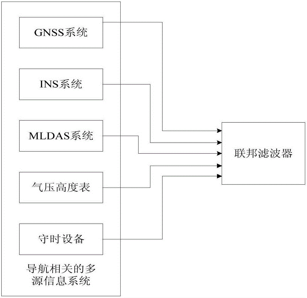
[0122] The applicant provides a combined navigation architecture based on multi-source information fusion through in-depth analysis of the data sources and relevance of the navigation system, such as figure 1 As shown, it includes a navigation-related multi-source information system and a federated filter for fusion processing of multi-source information. Among them, navigation-related multi-source information systems include but are not limited to one or more of the following: global satellite navigation system GNSS, inertial navigation system INS, multi-mode area differential augmentation system MLDAS, barometric altimeter and timekeeping equipment.
[0123] The selected multi-source information of the present invention will be analyzed below:
[0124] (1) Inertia assist can be used to improve airborne integrity
[0125] Inertial navigation has the ability to independently output carrier navigation information and attitude information without electromagnetic interference. I...
no. 2 example
[0283] Such as Figure 6 As shown, the embodiment of the present invention also provides a combined navigation method based on multi-source information, using the combined navigation device provided in Embodiment 1 to obtain multi-source navigation information, based on the respective characteristics of the multi-source information and the complementarity between each other, Improve the integrity of the GNSS navigation system, the method includes:
[0284] Step S601: Obtain multi-source navigation information, including obtaining from one or more of the global satellite navigation system GNSS, inertial navigation system INS, multi-mode area differential augmentation system MLDAS, barometric altimeter and timekeeping equipment installed on the aircraft navigation related information;
[0285] Step S602: Input each type of multi-source navigation information and a reference signal into a local filter;
[0286] Step S603: Trigger each local filter to calculate the local estimat...
PUM
 Abstract
Description
Claims
Application Information
 - R&D
- Intellectual Property
- Life Sciences
- Materials
- Tech Scout
- Unparalleled Data Quality
- Higher Quality Content
- 60% Fewer Hallucinations
Browse by: Latest US Patents, China's latest patents, Technical Efficacy Thesaurus, Application Domain, Technology Topic, Popular Technical Reports.
© 2025 PatSnap. All rights reserved.Legal|Privacy policy|Modern Slavery Act Transparency Statement|Sitemap|About US| Contact US: help@patsnap.com


