
Vehicle environment sensing system and method based on unmanned plane

A vehicle environment and perception system technology, applied in computer components, traffic flow detection, instruments, etc., can solve problems such as limited perception range and easy interference, so as to achieve clear relative position information of vehicles, easy perception, and stable working status Effect

Active Publication Date: 2016-04-20
BEIHANG UNIV
View PDF3 Cites 40 Cited by
  • Summary
  • Abstract
  • Description
  • Claims
  • Application Information

AI Technical Summary

Problems solved by technology

[0005] The present invention provides a vehicle environment perception system and method based on an unmanned aerial vehicle, aiming at the shortcomings of the existing vehicle environment perception technology, such as limited perception range and easy interference.

Method used


Image

  • Vehicle environment sensing system and method based on unmanned plane
  • Vehicle environment sensing system and method based on unmanned plane
  • Vehicle environment sensing system and method based on unmanned plane

Examples


Embodiment Construction

[0037] The present invention will be further described below in conjunction with accompanying drawing:

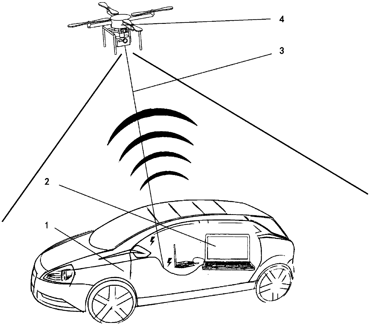
[0038] Such as figure 1 As shown, the present invention provides a UAV-based vehicle environment perception system, which includes: a target vehicle 1 requiring environment perception, a ground station 2, a mooring rope 3, and an unmanned aerial vehicle 4 . The ground station 2 communicates wirelessly with the unmanned aerial vehicle 4 and performs image transmission. The ground station 2 is placed on the target vehicle 1 and powered by the target vehicle 1 , and the unmanned aerial vehicle 4 is powered by the target vehicle 1 through the mooring rope 3 .

[0039] The unmanned aerial vehicle 4 is a four-rotor unmanned aerial vehicle. The UAV 4 is equipped with a GPS (Global Positioning System) module, an AHRS (Attitude Heading Reference System) module and a flight control device to ensure the stable and safe flight of the UAV. The unmanned aerial vehicle 4 is equipped wi...


PUM


Abstract

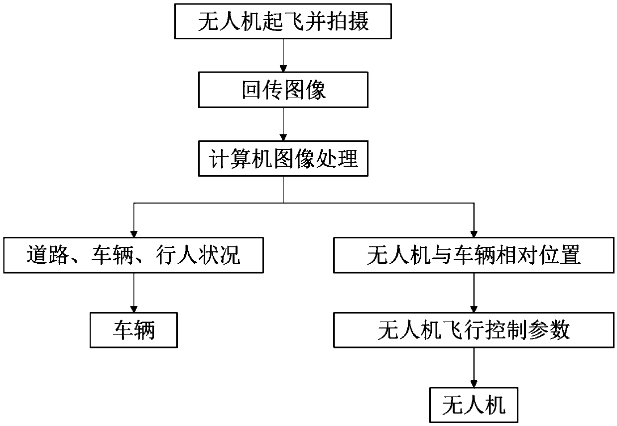
The invention relates to a vehicle environment sensing system and method based on an unmanned plane, and the system and method are used for quickly acquiring the road environment information around a vehicle. The sensing system comprises the unmanned plane and an earth station, the unmanned plane id connected with the vehicle through a mooring rope, the road surface is shot by the unmanned plane, and a video image is transmitted to the earth station; the earth station is arranged in the target vehicle, the earth station can process the video image to obtain the vehicle environment information, and the earth station also can calculate the flight control parameter and send the parameter to the unmanned plane to make the unmanned plane and the vehicle move together. The sensing method is based on the sensing system, the unmanned plane takes off and hovers above the vehicle, the unmanned plane establishes a communication for sensing the environment and transmits the video image to the earth station, the earth station processes the video image, calculates the vehicle environment information and transmits the information to the vehicle, and the earth station calculates the flight control parameter and transmits the parameter to the unmanned plane. According to the invention, the system can perform the wide area observation in the direction vertical to the vehicle plane direction, the coverage is wide, the road environment information around the target vehicle can be easily sensed, and the distance between the objects in the image can be precisely calculated.

Description

technical field [0001] The invention relates to the field of image processing, and in particular to an environment perception technology for a ground-selected vehicle based on an unmanned aerial vehicle platform, which can quickly acquire road environment information around the vehicle. Background technique [0002] Vehicles have developed into an indispensable means of transportation in modern society. The vehicle is stable and fast during driving, but it needs to obtain the corresponding peripheral environment information to ensure the safety of its operation. At this stage, the perception of the external environment of the vehicle mainly depends on the driver's artificial observation. Although human observation can quickly judge other vehicles, pedestrians, traffic signals and signs around, human perception depends on its own state. Alcohol, fatigue and lack of experience will reduce the accuracy of environmental perception, which usually leads to traffic accidents. In ...

Claims


Application Information

Patent Timeline
Patent Type & Authority Applications(China)
IPC IPC(8): G06K9/00G08G1/01
CPCG08G1/01G06V40/25
Inventor 王云鹏余贵珍李欣旭陈鹏马亚龙
Owner BEIHANG UNIV
Learn More