Unmanned aerial vehicle detection equipment for urban road identification

A detection equipment and road recognition technology, applied in character and pattern recognition, measurement devices, surveying and navigation, etc., can solve problems such as difficulty in obtaining high-precision urban road information, too primitive detection methods, and insufficient resolution of urban remote sensing images.

Inactive Publication Date: 2015-12-16
福建爱特点信息科技有限公司
View PDF6 Cites 12 Cited by
  • Summary
  • Abstract
  • Description
  • Claims
  • Application Information

AI Technical Summary

Problems solved by technology

However, the above two detection schemes have their own limitations: the former is difficult to obtain high-precision urban road information due to the insufficient resolution of urban remote sensing images; the latter requires a lot of manpower and material resources, and the detection method is too primitive. It consumes a lot of time and cost, and the real-time performance is very poor

Method used


Image

  • Unmanned aerial vehicle detection equipment for urban road identification

Examples


Embodiment Construction

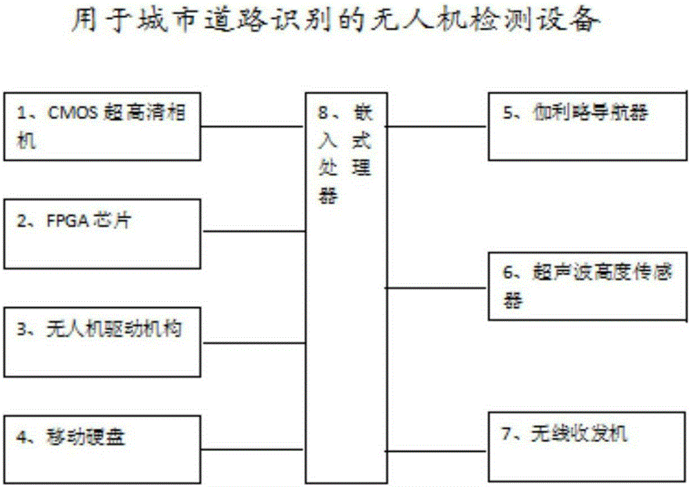
[0015] The implementation of the UAV detection device for urban road recognition of the present invention will be described in detail below with reference to the accompanying drawings.

[0016] Urban road is a kind of road that can reach various areas of the city, is used for transportation and pedestrians in the city, facilitates residents' life, work, cultural and entertainment activities, and connects with roads outside the city to bear external traffic. Urban roads are generally wider than highways. In order to adapt to complex means of transportation, motor vehicle lanes, bus priority lanes, non-motor vehicle lanes, etc. are divided. On both sides of urban roads, there are sidewalks and housing buildings that are higher than the road surface, and public pipelines are often buried under the sidewalks. There are green belts and sculptures on both sides of the urban roads to beautify the city. Forests are planted on both sides of the urban roads, and side ditches are placed t...


PUM


Abstract

The invention relates to unmanned aerial vehicle detection equipment for urban road identification. The detection equipment comprises an unmanned aerial vehicle driving mechanism, a CMOS ultrahigh-definition camera, an FPGA chip and an embedded processor, wherein the embedded processor is respectively connected with the unmanned aerial vehicle driving mechanism, the CMOS ultrahigh-definition camera and the FPGA chip, controls the unmanned aerial vehicle driving mechanism to drive an unmanned aerial vehicle to fly to a position right above an urban road to be detected, starts the CMOS ultrahigh-definition camera to photograph the urban road to be detected to obtain an urban road image after the unmanned aerial vehicle flies to the position right above the urban road to be detected, and starts the FPGA chip to process the urban road image to determine the road curve in the urban road image. Through the unmanned aerial vehicle detection equipment for urban road identification, the road curve information of the urban road to be detected can be flexibly and accurately surveyed, and more valuable reference data are provided for map drawing of urban survey departments.

Description

[0001] This invention is a divisional application of a patent with the application number 201510103082.7, the application date is March 10, 2015, and the invention name is "UAV detection equipment for urban road identification". technical field [0002] The invention relates to the field of road surveying and mapping, in particular to an unmanned aerial vehicle detection device for urban road identification. Background technique [0003] The relevant information of the urban road includes the curve trajectory of the urban road, positioning data and relative position, etc. Obtaining relevant information of urban roads is one of the necessary elements for urban management departments to draw urban maps. Correct urban road information can help urban management departments to plan urban management work, and also help other urban functional departments to carry out corresponding work. For example, it is convenient for urban traffic management departments to divide management area...

Claims


Application Information

Patent Timeline
Patent Type & Authority Applications(China)
IPC IPC(8): G01C11/00G01C11/02G06K9/00
CPCG01C11/00G01C11/02G06V20/182G06F18/00
Inventor 不公告发明人
Owner 福建爱特点信息科技有限公司
Why Eureka
Try Eureka