Urban garden greening management data interactive system and method thereof

A landscaping and data management technology, applied in data processing applications, electrical digital data processing, special data processing applications, etc., can solve the problems of system data deviation, reduction of the actual application value of the system, and lack of correlation of spatial data.

Active Publication Date: 2015-10-28
TAIHUA WISDOM IND GRP CO LTD
View PDF2 Cites 10 Cited by
  • Summary
  • Abstract
  • Description
  • Claims
  • Application Information

AI Technical Summary

Problems solved by technology

[0006] Business data is mostly stored in text, drawings, photos, etc., and lacks correlation with spatial data, and cannot intuitively and visually display spatial data and business data based on geographic location;
[0007] (2) Insufficient ability to dynamically update landscaping space data;
[0008] The existing landscaping GIS system lacks data update methods, or only provides a simple, small amount of data update. With the acceleration of urban construction, when the landscaping data is re-censused or the landscaping data in the region changes greatly, It is impossible to perform fast dynamic data update, and at the same time, the historical data cannot be retained during the spatial data update process, and the existing spatial data cannot be traced back;
[0009] The above problems have caused a large deviation between the system data and the actual data over time, and the statistical analysis results of the system query are inconsistent with the actual situation, and the actual application value of the system has been greatly reduced.
[0010] (3) Landscaping data cannot be shared in time, or the changed data cannot be shared in time;
[0011] The landscaping GIS system uses vector data. In order to ensure data security, the landscaping system generally converts the vector greening data into raster tile data after cutting the image, and then provides the landscaping data externally through the service. This method The tile data cannot be updated automatically, causing version inconsistencies between the shared landscaping data and the actual usage data

Method used


Image

  • Urban garden greening management data interactive system and method thereof
  • Urban garden greening management data interactive system and method thereof

Examples


Embodiment Construction

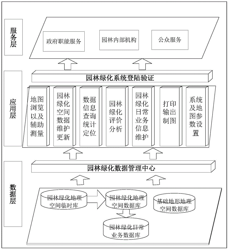
[0042] The present invention will be described in further detail below in conjunction with the accompanying drawings and embodiments.

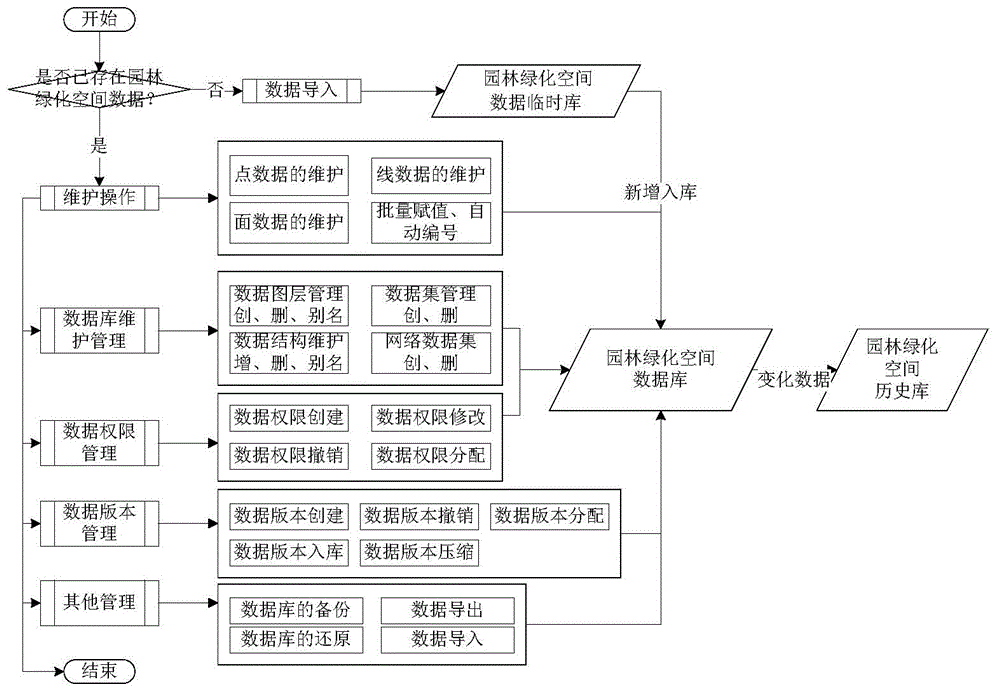
[0043] Such as figure 1 As shown, an urban landscaping management data interaction system includes: a data layer, which is used to store landscaping space data and basic data, and receives the data retrieval command sent by the landscaping data management center, and passes the data in the database through The landscaping data management center sends it to the application layer;

[0044] The landscaping data management center is the interface between the data layer and the application layer data connection, receives all data requests from the application layer to the data layer, and reads the data in the database in the data layer; the landscaping data management center also controls data access Permissions and access depth;

[0045] Application layer, which directly interacts with users, sends request commands to the landscaping data manage...


PUM


Abstract

The invention discloses an urban garden greening management data interactive system and a method thereof. The system comprises a data layer, an application layer and a service layer, wherein the data layer is used for storing garden greening spatial data and basic data, receiving a data calling command sent from a garden greening data management center and sending the data in a database to the application layer through the garden greening data management center; the garden greening data management center is an interface for data connection of the data layer and the application layer, is used for receiving all data requests with regard to the data layer from the application layer and reading the data in the database in the data layer, and is further used for controlling data access permissions and access depths; the application layer is in direct interaction with a user and is used for sending a request command for acquiring the data in the data layer to the garden greening data management center and maintaining, inquiring and editing the garden greening spatial data; and the service layer is used for calling an analysis result of the application layer and providing the analysis result for the corresponding user.

Description

technical field [0001] The invention relates to smart urban management, in particular to an urban landscaping management data interaction system and method thereof. technical background [0002] With the development of modern cities, the types and quantities of landscaping data are increasing day by day, and the difficulty of management is increasing. Generally speaking, landscaping data includes two types: one is landscaping data based on spatial location; the other is business data generated in daily management. Hereinafter referred to as landscaping space data and landscaping business data for short. How to display landscaping spatial data intuitively and visually, dynamically update the ever-changing temporal spatial data, and combine the daily business data of landscaping data based on spatial location to make better use of landscaping data has become a new topic. . [0003] However, the traditional landscaping geographic information system, referred to as landscapin...

Claims


Application Information

Patent Timeline
IPC IPC(8): G06F17/30G06Q50/26
Inventor 时念武马述杰周永利魏巍柳宇刚吴荣安王玉娥刘瑞明冯玉龙
Owner TAIHUA WISDOM IND GRP CO LTD
Why Eureka
Try Eureka