Irrigated area canal system surveying method and system based on GPS (Global Position System) positioning

A GPS positioning and surveying system technology is applied in the field of irrigation area canal survey method and survey system based on GPS positioning, which can solve the needs of irrigation farmers who are difficult to master and use, lack of usability and convenience, and difficult to support irrigation area management. and other issues to achieve the effect of satisfying ease of use and convenience, low cost and strong applicability

Active Publication Date: 2015-08-12
TSINGHUA UNIV
View PDF3 Cites 11 Cited by
  • Summary
  • Abstract
  • Description
  • Claims
  • Application Information

AI Technical Summary

Problems solved by technology

[0004] In addition, channel survey and drawing methods using theodolite and CAD as the main tools are highly professional, making it difficult for local irrigation district management units and irrigation farmers to master and use them. Generally, local professional surveyors need to be invited to operate, which is not easy to use and convenient. Difficult to support the needs of modern irrigation district management

Method used


Image

  • Irrigated area canal system surveying method and system based on GPS (Global Position System) positioning
  • Irrigated area canal system surveying method and system based on GPS (Global Position System) positioning
  • Irrigated area canal system surveying method and system based on GPS (Global Position System) positioning

Examples


Embodiment Construction

[0027] The following describes in detail the embodiments of the present invention, examples of which are illustrated in the accompanying drawings, wherein the same or similar reference numerals refer to the same or similar elements or elements having the same or similar functions throughout. The embodiments described below with reference to the accompanying drawings are exemplary, and are intended to explain the present invention and should not be construed as limiting the present invention.

[0028] In addition, the terms "first" and "second" are only used for descriptive purposes, and should not be construed as indicating or implying relative importance or implying the number of indicated technical features. Thus, a feature defined as "first" or "second" may expressly or implicitly include one or more of that feature. In the description of the present invention, "plurality" means two or more, unless otherwise expressly and specifically defined.

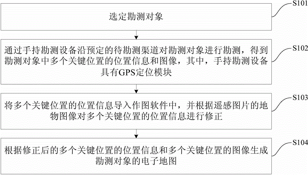
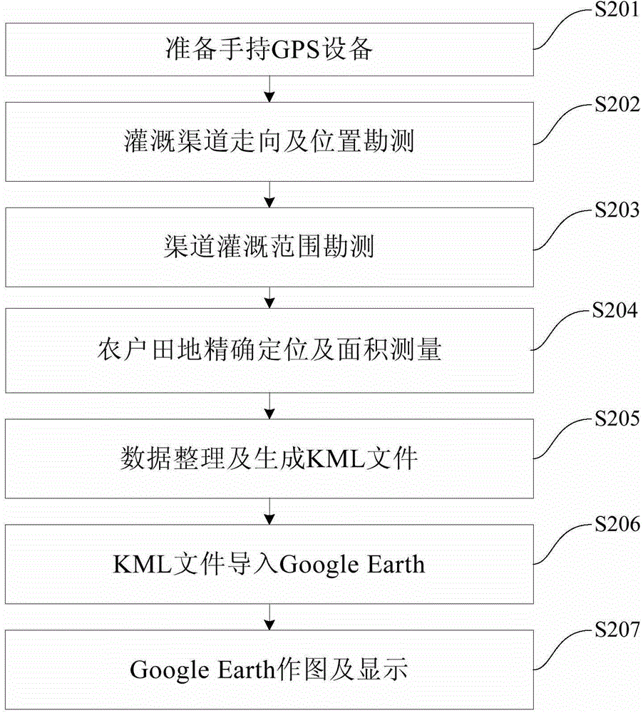
[0029] In the present inven...


PUM


Abstract

The invention discloses an irrigated area canal system surveying method based on GPS (Global Position System) positioning. The irrigated area canal system surveying method comprises the following steps: selecting a surveying object; surveying along a pre-set canal to be surveyed through handheld surveying equipment to obtain position information and images of a plurality of key positions; introducing position information of the plurality of key positions into drawing software, and revising the position information of the plurality of key positions according to a surface feature image of a remote sensing picture; and generating an electronic map of a surveyed object according to the revised position information of the plurality of key positions and the images of the plurality of key positions. The surveying method has the advantages of low cost, simplicity and feasibility, and rapidness and convenience, has strong applicability and meets the requirements of usability and convenience. The embodiment of the invention further discloses an irrigated area canal system surveying system based on the GPS positioning.

Description

technical field [0001] The invention relates to the technical field of surveying and positioning, in particular to a surveying method and surveying system for irrigation area canal systems based on GPS positioning. Background technique [0002] Irrigation area is an important organizational unit for irrigated agricultural production and water management, and channels are the basic engineering facilities for irrigation and water delivery. The maintenance, management and upgrading of irrigation channels are an important part of water resources management in irrigation areas. Concrete lining of channels is the main engineering method to improve irrigation efficiency and save water in irrigation areas. However, the lining length of irrigation canals in the country is less than 30%, and the irrigation efficiency of small and medium-sized irrigation areas is still low. [0003] The basic content of irrigation area channel management is to collect the spatial location information ...

Claims


Application Information

Patent Timeline
Patent Type & Authority Applications(China)
IPC IPC(8): G01C15/00
CPCG01C15/00
Inventor 郑航王忠静赵建世杨占荣盛彩虹卢书超
Owner TSINGHUA UNIV
Why Eureka
Try Eureka