A subject-oriented large-scale geospatial data dynamic fusion method
A geospatial data, subject-oriented technology, applied in the field of geospatial information, can solve problems such as the inability to better realize comprehensive operation management dynamic information, dynamic fusion fault tolerance and recklessness.
- Summary
- Abstract
- Description
- Claims
- Application Information
AI Technical Summary
Problems solved by technology
Method used
Image
Examples
Embodiment Construction
[0029] In order to better understand the above objects, advantages and features of the present invention, the present invention will be further described in detail below in conjunction with the accompanying drawings and specific embodiments.
[0030] In the following description, many specific details are set forth in order to fully understand the present invention. However, the present invention can also be implemented in other different and re-described methods, so the present invention is not limited to the specific implementation restrictions disclosed below.
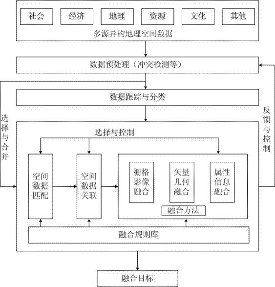
[0031] figure 1 It is a schematic diagram of subject-oriented large-scale geospatial data dynamic fusion.
[0032] Such as figure 1 As shown, the theme-oriented large-scale geospatial data dynamic fusion technology provided by the present invention includes: multi-source heterogeneous geospatial data; data preprocessing (conflict detection, etc.), and the multi-source heterogeneous geospatial data obtained Conflic...
PUM
 Abstract
Description
Claims
Application Information
 - Generate Ideas
- Intellectual Property
- Life Sciences
- Materials
- Tech Scout
- Unparalleled Data Quality
- Higher Quality Content
- 60% Fewer Hallucinations
Browse by: Latest US Patents, China's latest patents, Technical Efficacy Thesaurus, Application Domain, Technology Topic, Popular Technical Reports.
© 2025 PatSnap. All rights reserved.Legal|Privacy policy|Modern Slavery Act Transparency Statement|Sitemap|About US| Contact US: help@patsnap.com

