Eureka AIR delivers breakthrough ideas for toughest innovation challenges, trusted by R&D personnel around the world.

Applicability discrimination method for coordinate transformation model

A technology of coordinate conversion and discrimination method, which is applied in special data processing applications, instruments, electrical digital data processing, etc., and can solve the problems of not considering the accuracy of conversion coincidence point results, coincidence errors, etc.

Inactive Publication Date: 2015-05-06
国家测绘地理信息局大地测量数据处理中心
View PDF5 Cites 12 Cited by
  • Summary
  • Abstract
  • Description
  • Claims
  • Application Information

AI Technical Summary

Problems solved by technology

However, the coordinate transformation involved in the prior art does not consider the accuracy of the results of the transformation coincidence point, but relies on the size of the transformation residual to determine the transformation model. The transformation residual is the back-substitution error of the coincidence point in the same coordinate system. The situation reflects the conformity error, not the conversion coordinate accuracy

Method used


Image

  • Applicability discrimination method for coordinate transformation model
  • Applicability discrimination method for coordinate transformation model
  • Applicability discrimination method for coordinate transformation model

Examples


Embodiment 1

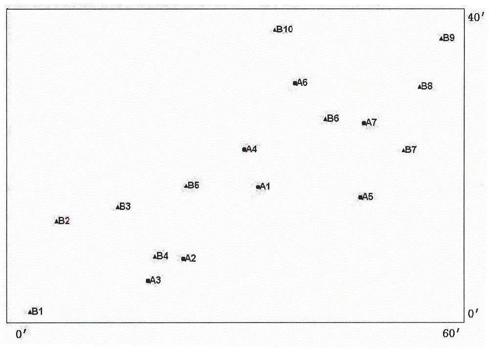
[0046] The independent coordinate system of a certain city provided by the embodiment of the present invention is established based on the Krasovsky ellipsoid, and is projected on the reference ellipsoid. The early urban basic control network was laid out by triangulation method, and the GPS control network was laid successively to control the original The grid was transformed, and the horizontal accuracy of the results of the two adjustments of the CGCS2000 geodetic coordinate system were 1cm and 0.3cm respectively. The coordinate transformation of the two phases uses different coincident points, 7 points in the early stage and 10 points in the later stage, and the independent coordinates are the coordinates generated by the transformation in 2001, such as figure 1 As shown, A is the early coincidence point, and B is the late coincidence point.

[0047] 1. Coordinate transformation

[0048] Use the same model to transform the coordinates of the two periods of data respective...


PUM


Abstract

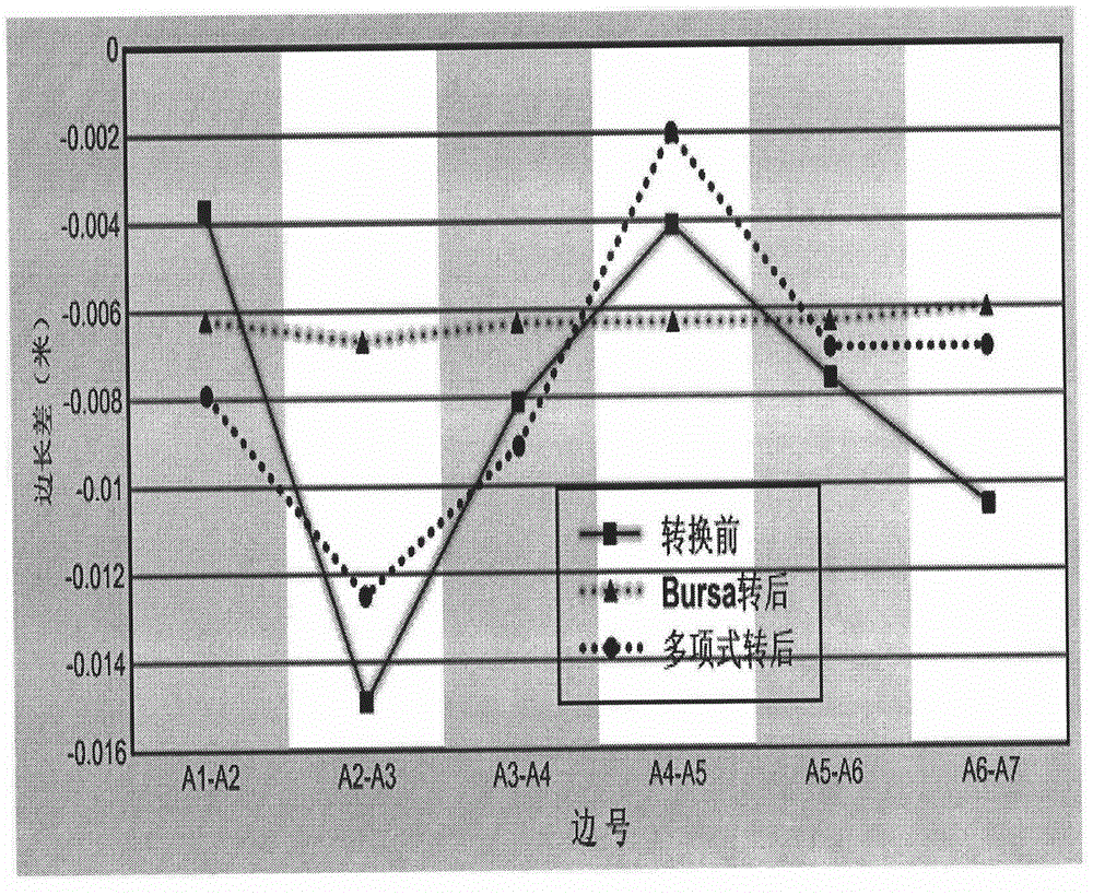
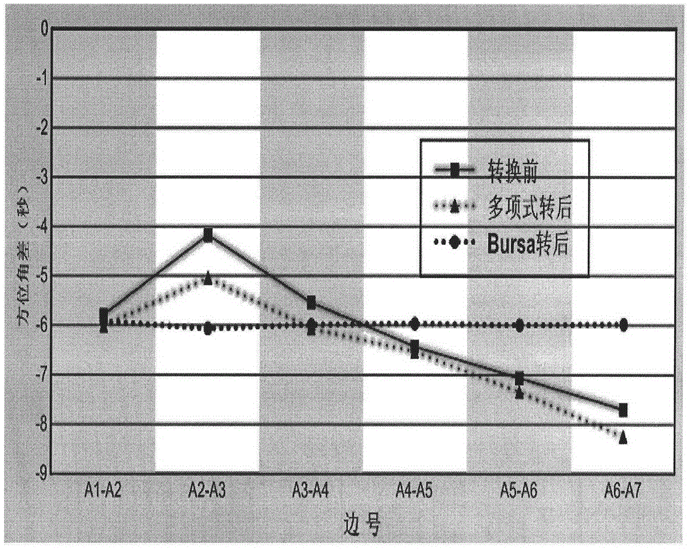
The invention provides an applicability discrimination method for a coordinate transformation model. The applicability discrimination method comprises the following steps: comparing transformation coordinates generated by a common transformation model by using a side length difference and an azimuth angle difference model of a CGCS2000 geodetic coordinate system and a national reference-ellipsoid-centric coordinate system; carrying out check analysis on the characteristics of the transformation model by using a side length difference and an azimuth angle difference according to the variation quantity and the variation trend; verifying data by using two stages of GPS (Global Positioning System) control networks in one region to reflect the characteristics of the transformation model; verifying the characteristics of the transformation coordinates by utilizing data of the GPS control network and transforming between the CGCS2000 geodetic coordinate system and the national reference-ellipsoid-centric coordinate system. According to the applicability discrimination method provided by the invention, the problem of difficult model selection for different demands in the coordination transformation process is solved, the problems that the precision is evaluated by completely depending on transformation residual and the precision estimation of the transformation residual has certain limitation in the previous coordinate transformation are solved, vast transformation workload is avoided, a large amount of cost and time are reduced and saved, and popularization and application of the CGCS2000 geodetic coordinate system are facilitated.

Description

technical field [0001] The invention relates to the technical fields of geodetic surveying and engineering surveying, in particular to a method for judging the applicability of a coordinate transformation model. Background technique [0002] my country has a vast territory and complex terrain. Most of the current independent coordinate systems of cities were established on the basis of the national ginseng coordinate system in the 1950s and 1960s. Due to the limitations of technical conditions and the accuracy of control points at that time, it is difficult to meet the needs of current economic construction. . [0003] The control network of the national ginseng coordinate system (54 series and 80 series) was limited by the level of science and technology at that time, and the relative accuracy of the geodetic control points was 10 -6 , and with the development of social economy and the advancement of science and technology, the use of CGCS2000, that is, the urban independen...

Claims


Application Information

Patent Timeline
IPC IPC(8): G06F19/00
Inventor 郭春喜李东陈俊英谢方
Owner 国家测绘地理信息局大地测量数据处理中心
Why Eureka
Eureka Blog
Learn More