Robot system and map updating method

一种机器人系统、地图更新的技术,应用在机器人系统领域,能够解决误差、误差蓄积等问题,达到精度不会降低的效果

Active Publication Date: 2017-09-08
HITACHI IND EQUIP SYST CO LTD
View PDF6 Cites 0 Cited by
  • Summary
  • Abstract
  • Description
  • Claims
  • Application Information

AI Technical Summary

Problems solved by technology

However, each of the two environment maps has an error, so in the updated environment map obtained based on the connection point set on the two environment maps, a new error occurs with respect to the past environment map.
As a result, when updating is repeated, errors accumulate

Method used


Image

  • Robot system and map updating method
  • Robot system and map updating method
  • Robot system and map updating method

Examples


Embodiment 1

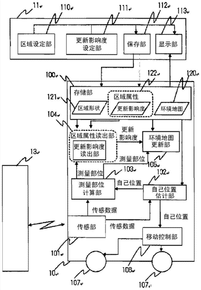
[0042] figure 1 It is a conceptual diagram showing the robot system of this embodiment. First, the robot system of the present invention is constituted by the mobile robot 10 and the area setting device 11 . The mobile robot 10 includes an environment map 120 representing the shape of an object existing in space, a storage unit 100 for storing a plurality of pairs of an area shape 121 and an area attribute 122, a sensor unit 101 for measuring surrounding shapes, and an own position estimation unit 102 , a measurement site calculation unit 103 , an area attribute readout unit 104 , an environment map update unit 105 , a movement control unit 106 for determining the direction and amount of movement based on the position of the robot, and a movement mechanism unit 107 .

[0043] In addition, in the present embodiment, the area attribute 122 indicates the update influence degree which is the degree of influence on the environment map at the time of update, and the area attribute...

Embodiment 2

[0075] In the above-described embodiment, a distance sensor for measuring an object existing on a two-dimensional plane has been used as the sensor unit 101 . On the other hand, a distance sensor capable of measuring a three-dimensional shape may be used as the sensor unit 101 . Next, an example using a three-dimensional distance sensor will be described.

[0076] In the case of processing a three-dimensional space, when the space is divided into grids, a huge amount of memory is used. Therefore, a collection of measured points (point group) measured by the distance sensor is directly held in the storage unit 100 . Of course, when a computer equipped with a large number of storage media can be used, grids can also be processed as in the above-described embodiment.

[0077] The sequence of functions / processes mounted on the mobile robot is the same as in the above-described embodiments. Each function is explained below.

[0078] In this method, objects in space are represen...


PUM


Abstract

The invention provides a robot system and a map updating method. Due to the map update, an error occurs between the past environment map and the updated environment map. Therefore, when the update process is repeated, errors accumulate. The robot system includes: a mobile robot having a sensor for measuring a surrounding shape; a storage unit for distinguishing an environment map representing a shape in a space into at least a shape-variable region that is updated and a shape-invariant region that is not updated. storing; and a map updating unit that updates the environment map with the measured shape when the position of the shape measured by the sensor is included in the shape variable area, and the mobile robot refers to the updated map of the environment for movement.

Description

[0001] This application is a divisional application of the original application whose filing date is October 24, 2011, the application number is 201110324396.1, and the invention name is "Robot System and Map Update Method". technical field [0002] The present invention relates to a method for updating an environment map referenced by an autonomous mobile robot and a robot system. Background technique [0003] The autonomous movement of the robot is performed by obtaining the movement control from the current position and posture of the robot with reference to the path indicating the movement sequence of the robot. For example, according to Patent Document 1, the robot can perform a basic operation of autonomous movement until reaching a destination by movement control based on set movement route data. In Patent Document 1, a path of robot movement is generated on an environment map representing the geometrical conditions of objects in space, and movement control is perform...

Claims


Application Information

Patent Timeline
Patent Type & Authority Patents(China)
IPC IPC(8): G01C21/00G09B29/00
CPCG01C21/005G05D1/0272B25J9/1694B25J13/08B25J19/02B60W20/12G01S17/89G05D1/0274
Inventor 藤本敬介木村宣隆守屋俊夫
Owner HITACHI IND EQUIP SYST CO LTD
Why Eureka
Try Eureka