A Flood Forecasting Method and System Based on Historical Data
A flood forecasting and historical data technology, applied in electrical digital data processing, special data processing applications, instruments, etc., can solve the problems of low precision and accuracy of flood forecasting, and achieve the effect of high precision and accuracy
- Summary
- Abstract
- Description
- Claims
- Application Information
AI Technical Summary
Problems solved by technology
Method used
Image
Examples
Embodiment 1
[0046] A flood forecasting method based on historical data provided by an embodiment of the present invention is introduced in detail.
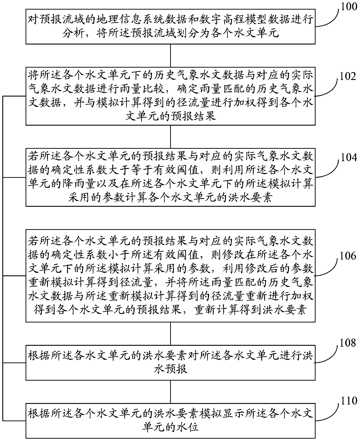
[0047] refer to figure 1 , shows a flow chart of a flood forecasting method based on historical data in an embodiment of the present invention.
[0048] Step 100, analyze the geographic information system data and digital elevation model data of the forecast watershed, and divide the forecast watershed into various hydrological units.
[0049] According to GIS data and Digital Elevation Model (Digital Elevation Model, DEM) data, using the starting latitude and longitude of the forecast watershed, the topological structure of each hydrological unit in the forecast watershed can be extracted. Then, the historical meteorological and hydrological data of the forecast basin are weighted and averaged according to the nodes in the topological structure of each hydrological unit to obtain the historical meteorological and hydrological data of each h...
Embodiment 2
[0073] A flood forecasting method based on historical data provided by an embodiment of the present invention is introduced in detail.
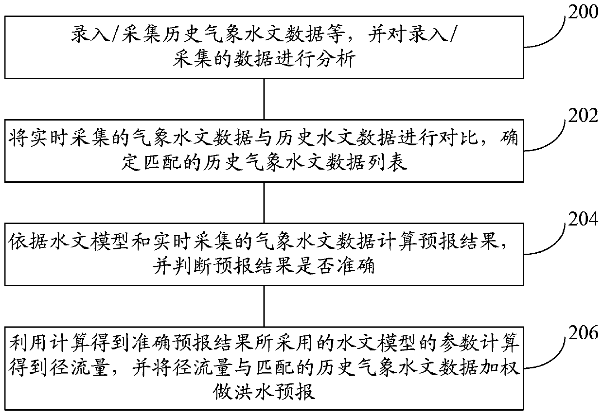
[0074] refer to figure 2 , shows a flow chart of a flood forecasting method based on historical data in an embodiment of the present invention.
[0075] Step 200, inputting / collecting historical meteorological and hydrological data, etc., and analyzing the entered / collected data.
[0076] The entered / acquired data may include GIS data, DEM data, meteorological data, hydrological data, flood event data, and remote sensing data.
[0077] Analyze the input / collected data to obtain the topological structure of the river network, the terrain of the underlying surface, the central zone of the storm, the relationship between rainfall and water level, and the relationship between rainfall and disasters.
[0078] Step 202, comparing the meteorological and hydrological data collected in real time with the historical hydrological data, and determinin...
Embodiment 3
[0086] A flood forecasting system based on historical data provided by the embodiment of the present invention is introduced in detail.
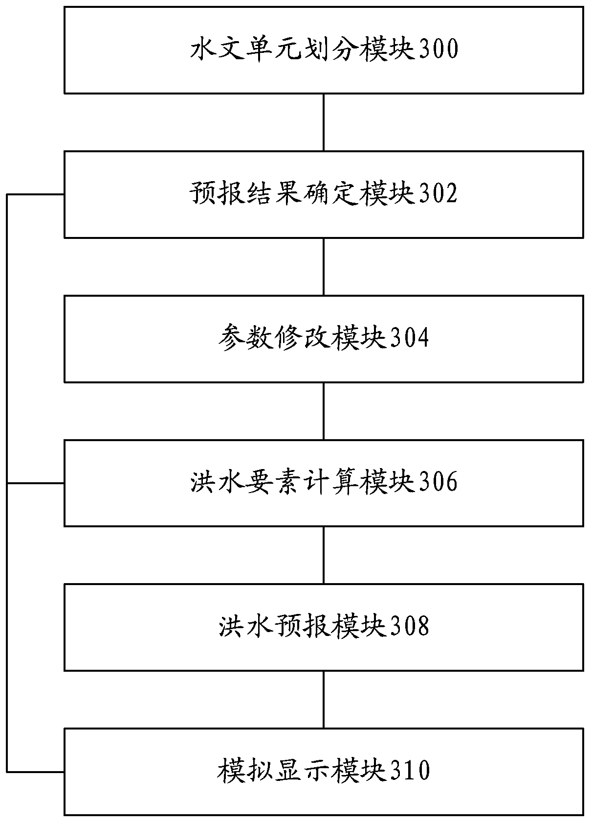
[0087] refer to image 3 , shows a structural diagram of a flood forecasting system based on historical data in an embodiment of the present invention.
[0088] The flood forecasting system based on historical data may include: a hydrological unit division module 300, a forecast result determination module 302, a parameter modification module 304, a flood element calculation module 306, a flood forecast module 308, and a simulation display module 310.
[0089] The functions of each module and the relationship between each module are introduced in detail below.
[0090] The hydrological unit division module 300 is configured to analyze the geographic information system data and digital elevation model data of the forecast watershed, and divide the forecast watershed into various hydrological units.
[0091] The forecast result determination...
PUM
 Abstract
Description
Claims
Application Information
 - Generate Ideas
- Intellectual Property
- Life Sciences
- Materials
- Tech Scout
- Unparalleled Data Quality
- Higher Quality Content
- 60% Fewer Hallucinations
Browse by: Latest US Patents, China's latest patents, Technical Efficacy Thesaurus, Application Domain, Technology Topic, Popular Technical Reports.
© 2025 PatSnap. All rights reserved.Legal|Privacy policy|Modern Slavery Act Transparency Statement|Sitemap|About US| Contact US: help@patsnap.com


