
Robust filtering method for aerospace vehicle integrated navigation based on launch inertial coordinate system

An inertial coordinate system and aerospace vehicle technology, which is applied in the field of robust filtering of aerospace vehicle integrated navigation, can solve the problems of Kalman filter filtering performance limitations, difficulty in obtaining accurate models of navigation systems, and many uncertain factors

Inactive Publication Date: 2017-04-05
NANJING UNIV OF AERONAUTICS & ASTRONAUTICS
View PDF8 Cites 0 Cited by
  • Summary
  • Abstract
  • Description
  • Claims
  • Application Information

AI Technical Summary

Problems solved by technology

The flight environment faced by aerospace vehicles is complex and there are many uncertain factors, which usually have unpredictable effects on the navigation system, and it is difficult to obtain an accurate model of the navigation system.
Under the above conditions, the filtering performance of the Kalman filter will be limited

Method used


Image

  • Robust filtering method for aerospace vehicle integrated navigation based on launch inertial coordinate system
  • Robust filtering method for aerospace vehicle integrated navigation based on launch inertial coordinate system
  • Robust filtering method for aerospace vehicle integrated navigation based on launch inertial coordinate system

Examples


specific Embodiment approach

[0053] 1. Establish the inertial navigation system solution model in the launching inertial coordinate system

[0054] (1.1) Velocity calculation model in launch inertial system

[0055] Coordinate system definition: e system—earth coordinate system; i system—geocentric inertial coordinate system; l system—launch inertial coordinate system; b system—carrier coordinate system (front, upper right); g system—geographical coordinate system

[0056] In the launch inertial coordinate system, the velocity calculation model of the carrier is:

[0057]

[0058] Among them, v l is the speed of the aircraft relative to the launching inertial system, is the aircraft speed v l The first derivative of ; f b is the specific force output by the accelerometer; G i is the gravitational force of the earth in the inertial coordinate system. Because the earth is a non-ideal sphere with different geological structures and uneven mass distribution, the gravitational field of the earth is n...


PUM


Abstract

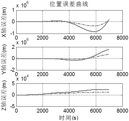
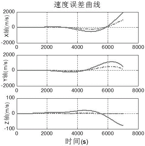
The invention discloses an aerospace vehicle combined navigation robust filtering method based on a launching inertia coordinate system, belonging to the technical field of air vehicle combined navigation. The aerospace vehicle combined navigation robust filtering method comprises the following steps of performing inertial navigation algorithm arrangement by taking the launching inertia coordinate system as a reference coordinate system, and constructing a position, speed and posture calculation model of an air vehicle under the launching inertia coordinate system; on the basis of the position, speed and posture calculation model, constructing an equation of navigation system error states including a basic navigation parameter error and an inertia instrument error, and obtaining a posture linear measurement equation through a conversion module according to original star sensor measurement information; and finally estimating and correcting all state values in the constructed state equation by the robust filtering method. According to the aerospace vehicle combined navigation robust filtering method disclosed by the invention, the influence, caused by a geophysical field, on the navigation system of the air vehicle can be effectively reduced; furthermore, under a condition that the navigation system model of the air vehicle is inaccurate, a filter can work stably; therefore, the precision of a combined navigation system is improved.

Description

technical field [0001] The invention discloses a robust filtering method for combined navigation of aerospace vehicles based on a launch inertial coordinate system, and relates to the technical field of combined navigation. Background technique [0002] In recent years, with the development of aerospace technology, new types of aircraft such as near-space hypersonic vehicles and aerospace vehicles have the characteristics of long endurance and large airspace flight, and their requirements for navigation system performance are increasing. [0003] Traditional aviation aircraft usually use the geographic coordinate system as the reference coordinate system for strapdown inertial navigation algorithm layout. In the strapdown inertial navigation system algorithm layout, the gravity field and curvature radius changes are directly ignored or simplified, mainly considering the geographical system layout. It is relatively intuitive, and in short-term and short-distance flights, this...

Claims


Application Information

Patent Timeline
Patent Type & Authority Patents(China)
IPC IPC(8): G01C21/20
CPCG01C21/20
Inventor 赵慧熊智潘加亮孙永荣郁丰刘建业许建新柏青青王融王洁程娇娇林爱军戴怡洁施丽娟孔雪博
Owner NANJING UNIV OF AERONAUTICS & ASTRONAUTICS
Learn More