
Airborne Color 3D Scanning LiDAR

A laser radar and three-dimensional scanning technology, applied in the field of surveying and mapping remote sensing, can solve problems such as difficult to obtain spectral features of ground objects, and achieve the effect of enhancing color resolution, improving feasibility, and increasing stability

Active Publication Date: 2016-03-30
WUHAN UNIV
View PDF8 Cites 0 Cited by
  • Summary
  • Abstract
  • Description
  • Claims
  • Application Information

AI Technical Summary

Problems solved by technology

However, due to the limitation of a single infrared laser wavelength, it is difficult to obtain effective spectral features of ground objects. It is usually necessary to match a color imaging camera for simultaneous detection to obtain corresponding texture and color spectral information.

Method used


Image

  • Airborne Color 3D Scanning LiDAR
  • Airborne Color 3D Scanning LiDAR
  • Airborne Color 3D Scanning LiDAR

Examples


Embodiment Construction

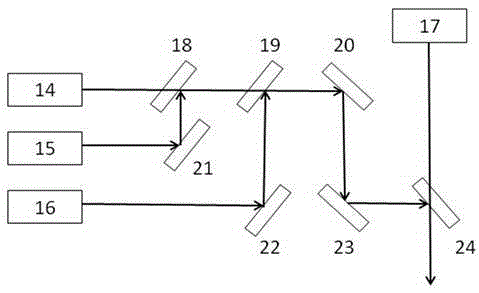
[0015] According to the principle of color synthesis of three primary colors of light, by adding the color laser wavelength of red, green and blue R.G.B or red, yellow and blue R.Y.B three-color synthesis in the visible light range to the existing single-wavelength laser radar technology, the detection data has color spectral echo intensity. and distance information. The push-broom 3D color laser scanning imaging detection is realized through the airborne platform, and the 3D space information and color laser spectrum information of the airborne lidar are directly obtained, so that the lidar can not only retain the 3D spatial resolution ability, but also have the color spectrum discrimination ability . The airborne color 3D scanning lidar can generate laser scanning imaging data with color laser spectral information at one time, which has higher spectral resolution and ground object recognition capabilities, and comprehensively improves the accuracy of lidar ground object reco...


PUM


Abstract

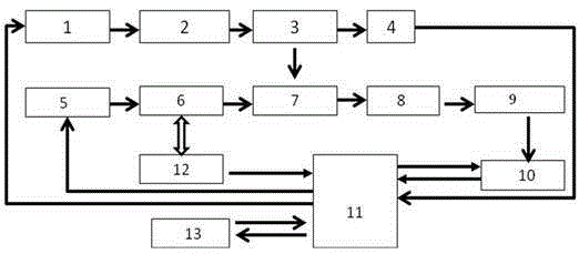
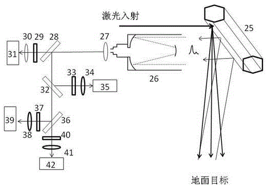
An on-board colorful three-dimensional scanning laser radar comprises a laser emission unit, a scanning unit, a signal detection signal, a time sequence control circuit and a computer data processing unit, wherein the scanning unit comprises a motor driver, a motor, a polyhedral scanning rotating mirror and an angle encoder, and the motor driver, the motor and the polyhedral scanning rotating mirror are sequentially connected, the angle encoder is connected with the motor, and the laser emission unit comprises a laser driver, a colorful laser source, an optical emission system and a PIN detector which are sequentially connected. The signal detection signal comprises a receiving optical system, a colorful laser signal detector and a multi-channel data acquisition unit which are sequentially connected. The time sequence control circuit is respectively connected with the laser driver, the PIN detector and the multi-channel data acquisition unit. The on-board colorful three-dimensional scanning laser radar can simultaneously obtain colorful laser spectral information and laser point cloud information of a target ground feature, accordingly obtains a colorful laser imaging of a target through three-dimensional reconstruction and strengthens the colorful resolution capability.

Description

technical field [0001] The invention relates to the technical field of surveying and mapping remote sensing, in particular to an airborne color three-dimensional scanning laser radar. Background technique [0002] Airborne earth observation lidar technology is an important remote sensing method to realize large-scale three-dimensional imaging and earth detection, and has outstanding advantages in quickly obtaining three-dimensional spatial information. However, due to the limitation of a single infrared laser wavelength, it is difficult to obtain effective spectral features of ground objects. It is usually necessary to match a color imaging camera for simultaneous detection to obtain corresponding texture and color spectral information. Contents of the invention [0003] The purpose of the present invention is to provide a one-dimensional linear scanning color laser radar, which can realize color three-dimensional scanning imaging detection through an airborne platform. B...

Claims


Application Information

Patent Timeline
Patent Type & Authority Patents(China)
IPC IPC(8): G01S17/89
CPCG01S7/481G01S7/483G01S17/89
Inventor 宋沙磊龚威祝波史硕李德仁
Owner WUHAN UNIV
Learn More