Digital lake three-dimensional visualized simulation method and simulation platform based on OSG
A simulation method and lake technology, applied in the field of virtual reality, can solve the problems of using basic primitives, difficulty in writing complex scenes, difficulty in designing scenes and operating objects in scenes, etc., to achieve the effect of easy expansion and convenient operation.
- Summary
- Abstract
- Description
- Claims
- Application Information
AI Technical Summary
Problems solved by technology
Method used
Image
Examples
Embodiment Construction
[0037] The present invention is described in detail below in conjunction with accompanying drawing:
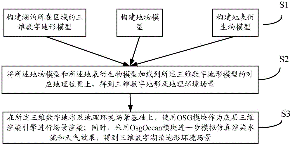
[0038] Such as figure 1 As shown, the present invention provides a kind of OSG-based digital lake three-dimensional visual simulation method, comprising the following steps:
[0039] S1, constructing a three-dimensional digital terrain model of the area where the lake is located; and, constructing a ground object model and a surface derivative model;
[0040] Specifically, geographic information system software such as ArcGIS can be used to import the DEM (Digital Elevation Model) data of the target terrain to obtain the initial shape of the target terrain, and then perform further operations such as calibration, cutting, and splicing to generate a 3D digital terrain that meets the requirements Model.
[0041] The ground object model and the surface derivative model can be modeled by using some known auxiliary modeling software, for example: use 3DS MAX, Photoshop and other ...
PUM
 Abstract
Description
Claims
Application Information
 - R&D Engineer
- R&D Manager
- IP Professional
- Industry Leading Data Capabilities
- Powerful AI technology
- Patent DNA Extraction
Browse by: Latest US Patents, China's latest patents, Technical Efficacy Thesaurus, Application Domain, Technology Topic, Popular Technical Reports.
© 2024 PatSnap. All rights reserved.Legal|Privacy policy|Modern Slavery Act Transparency Statement|Sitemap|About US| Contact US: help@patsnap.com


