A ground-based cloud image distortion correction method for all-sky imager

An all-sky imager and ground-based cloud image technology, which is applied in the fields of instruments, image enhancement, image data processing, etc., can solve problems such as image distortion, cloud amount calculation, and difficulty in cloud trajectory prediction

Active Publication Date: 2016-05-25
STATE GRID CORP OF CHINA +2
View PDF2 Cites 0 Cited by
  • Summary
  • Abstract
  • Description
  • Claims
  • Application Information

AI Technical Summary

Problems solved by technology

However, because the imaging method of the all-sky imager is convex mirror imaging, and the imaging angle of view and other problems, the images taken by it have certain distortions, which brings difficulties to cloud amount calculation and cloud trajectory prediction.

Method used


Image

  • A ground-based cloud image distortion correction method for all-sky imager
  • A ground-based cloud image distortion correction method for all-sky imager
  • A ground-based cloud image distortion correction method for all-sky imager

Examples


Embodiment Construction

[0058] The present invention will be described in further detail below in conjunction with the accompanying drawings.

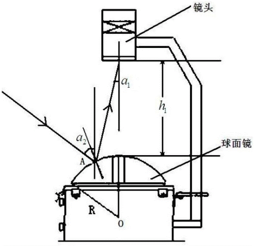
[0059] Such as Figure 1-Figure 4 , a ground-based cloud image distortion correction method for an all-sky imager, said method comprising the following steps:

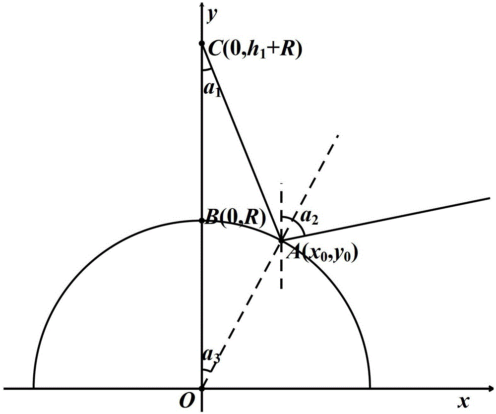
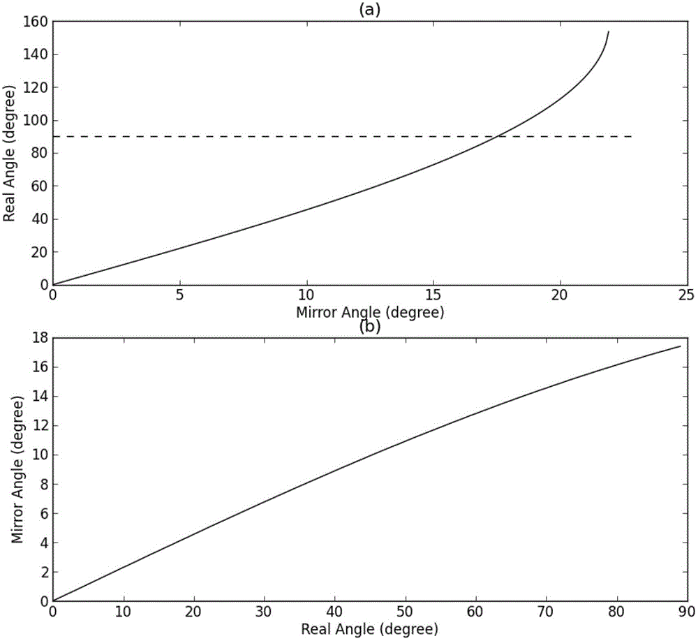
[0060] Step 1: Establish the conversion function between the spherical distortion zenith angle and the actual zenith angle in the ground-based nephogram;

[0061] Step 2: Transform the ground-based cloud image into a spherical coordinate system cloud image;

[0062] Step 3: Convert the cloud image in the spherical coordinate system into an actual cloud image in the plane Cartesian coordinate system.

[0063] Described step 1 comprises the following steps:

[0064] Step 1-1: Establishing the imaging distortion model of the all-sky imager;

[0065] Step 1-2: Establish a conversion function between the spherical distortion zenith angle and the actual zenith angle in the ground-based nephogram accordi...


PUM


Abstract

The present invention provides a land-based cloud chart aberration correction method for a whole sky imager, and relates to the technical field of photovoltaic power generation and power distribution. The method comprises the following steps: establishing a conversion function between a spherical aberration zenith angle in a land-based cloud chart and an actual zenith angle; converting the land-based cloud chart into a cloud chart of a spherical coordinates system; and converting the cloud chart of a spherical coordinates system into a cloud chart of a rectangular plane coordinate system. In the method, few parameters are required, and only a few of parameters such as a distance between a lens of a whole sky imager and a spherical lens, and a radius of the spherical lens are required; input data is simple, and it is only required to input original land-based cloud chart data for implementing the correction; and image information has no loss during the conversion.

Description

technical field [0001] The invention belongs to the technical field of photovoltaic power generation and distribution, and in particular relates to a ground-based cloud image distortion correction method for an all-sky imager. Background technique [0002] In recent years, solar technology and applications have developed rapidly. As of 2010, the cumulative installed capacity of photovoltaics in the world has reached nearly 40GW, with an average annual growth rate of 45% in the past ten years, making it one of the fastest growing industries. However, due to the randomness and intermittent nature of solar power generation, the grid connection of large-scale solar power generation will bring impacts and challenges to the safe and stable operation of the power grid. Therefore, timely and effective monitoring and forecasting of regional solar energy resources has become a key factor restricting the integration of photovoltaic power generation into the grid. [0003] At present,...

Claims


Application Information

Patent Timeline
Patent Type & Authority Patents(China)
IPC IPC(8): G06T5/00
CPCG02B13/06G06T3/00
Inventor 丁宇宇丁杰周海程序陈颖崔方曹潇王知嘉于炳霞谭志萍周强陈志宝
Owner STATE GRID CORP OF CHINA
Why Eureka
Try Eureka