
BD/DNS/IMU autonomous integrated navigation system and method thereof

An integrated navigation system and Doppler radar technology, which is applied in the field of Beidou/Doppler radar/inertial autonomous integrated navigation system, can solve the problems of high cost, low navigation accuracy, and low precision, and achieve strong environmental adaptability, The effect of high navigation accuracy and strong compatibility

Inactive Publication Date: 2014-01-01
NANJING UNIV OF SCI & TECH
View PDF2 Cites 49 Cited by
  • Summary
  • Abstract
  • Description
  • Claims
  • Application Information

AI Technical Summary

Problems solved by technology

[0004] 1) The GPS / IMU integrated navigation system has the advantages of high precision and low cost, but the system relies heavily on the accuracy of GPS. Combining the Beidou satellite receiver (BD) with the IMU can form an integrated navigation system similar to GPS / IMU BD / IMU is an autonomous integrated navigation system, but because my country's Beidou satellites have not yet achieved a comprehensive network, and at the same time, if the helicopter flies to the canyon, surrounding mountains and urban buildings for rescue, the satellite signal will be lost due to multipath and other reasons. It cannot be positioned normally, and the aviation-grade inertial navigation used will produce a large navigation error in a short period of time without receiving effective satellite navigation signals and cannot provide reliable navigation information for the carrier aircraft;
[0005] 2) The dead reckoning navigation system composed of Doppler radar and Airborne Heading and Attitude System (AHRS), that is, Doppler Navigation System (Doppler Navigation System, DNS), simply performs integral calculation, and the The error is not estimated and eliminated in real time, so the navigation accuracy is relatively low, usually between 1% and 2% (2σ) of the flight distance, and the error is relatively large;
[0006] 3) Doppler radar / inertial autonomous integrated navigation system has greatly improved the accuracy compared with pure inertial navigation and DNS systems, usually between 0.15% and 0.25% (2σ) of the flight distance, which can meet the The basic needs of the airborne navigation system, but the observations of this combination mode only have velocity information, and the position channel has no external information for damping, so the navigation error will still accumulate and increase with time, which cannot meet the autonomous navigation requirements of the airborne long-term voyage, and It requires external position information for initial alignment
[0007] To sum up, the current airborne navigation system has poor stability, low precision, and high cost, and the error will accumulate and increase with time, which cannot meet the needs of airborne long-endurance autonomous navigation.

Method used


Image

  • BD/DNS/IMU autonomous integrated navigation system and method thereof
  • BD/DNS/IMU autonomous integrated navigation system and method thereof
  • BD/DNS/IMU autonomous integrated navigation system and method thereof

Examples


Embodiment 1

[0110] The Beidou / Doppler radar / inertial autonomous integrated navigation system and method thereof of the present invention are applied to the helicopter autonomous integrated navigation system, and a biaxial turntable test and a one-way approximate straight line high-speed road sports car test are carried out:

[0111] (1) Two-axis turntable test In order to test whether the attitude angle of the Beidou / Doppler radar / inertial autonomous integrated navigation system is divergent under the body swing environment (for the helicopter's flight environment, mainly the pitch and heading channels), a high-precision The dual-axis turntable has carried out the turntable test on the designed prototype of the integrated navigation system, and the extreme values ​​of the attitude error under each swing condition are shown in Table 1.

[0112] Table 1 The extreme value of attitude error under each swing condition

[0113]

[0114] (2) The high-speed one-way sports car test can simulate...


PUM


Abstract

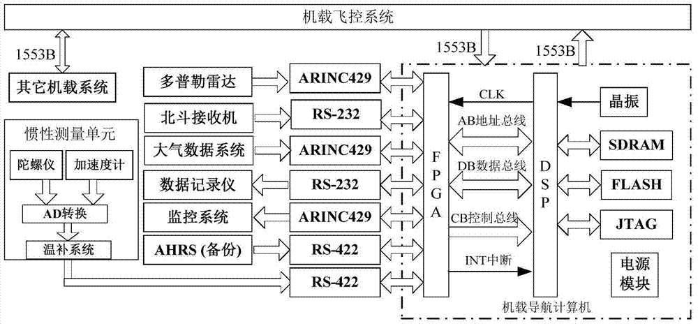
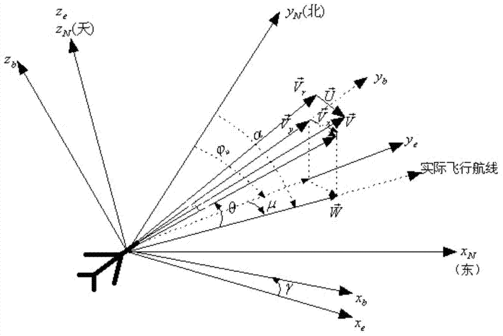
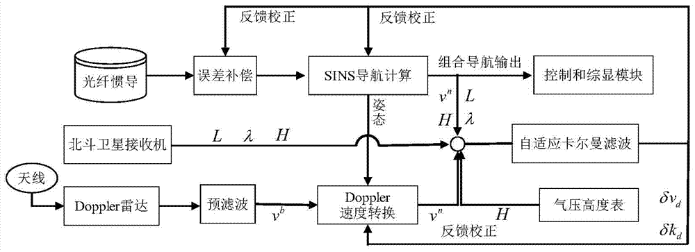
The invention discloses a BD / DNS / IMU autonomous integrated navigation system and a method thereof. The system includes an airborne navigation computer, an IMU, a Doppler radar, a BD, an air data system, a data recorder, a monitoring system and an AHRS, wherein the IMU, the Doppler radar, the BD, the air data system, the data recorder, the monitoring system and the AHRS are connected with the airborne navigation computer. The method comprises the steps that a self-adapted Kalman filtering model is established by the adoption of a 'position + speed' matching mode, after pose matrix transformation is performed on the Doppler radar, differential operation is performed on velocity measurement information under the navigation system and velocity information calculated through inertial navigation solutions, and differential operation is performed on the position information outputted by the BD and the position information calculated through inertial navigation solutions; difference values obtained serve as observed quantity to perform Kalman filtering information fusion, and loop iteration is preformed on error variances of all branch systems in a state equation of a filtering estimating system; real-time closed-loop estimation is carried out, and all parametric variables in an inertial navigation system, the Doppler radar and the BD are amended to obtain final integrated navigation results after filtering correction. According to the BD / DNS / IMU autonomous integrated navigation system and the method thereof, long-endurance navigation can be carried out in an airborne and seamless mode in real time, navigation accuracy is high, and cost is low.

Description

1. Technical field [0001] The invention relates to the technical field of aerospace integrated navigation, in particular to a Beidou / Doppler radar / inertial autonomous integrated navigation system and a method thereof. 2. Background technology [0002] The practical experience of several modern local wars shows that although the GPS positioning system has an unmatched accuracy by other positioning systems, its autonomy is poor, and it may be shielded or added garbled characters to cause interference during wartime. Medium and long-distance navigation with high cost, high precision, and good tactical characteristics is an urgent problem to be solved in my country's military navigation system. Due to the combat mission and usage characteristics of armed helicopters, the military airborne navigation system needs to meet the following requirements: shorten the preparation time before the navigation system takes off, can quickly transfer from the preparation state to the wartime st...

Claims


Application Information

Patent Timeline
IPC IPC(8): G01S19/48
CPCG01S19/48G01C21/165G01C25/005G01S13/86G01S19/49
Inventor 白宏阳孙瑞胜薛晓中李伟明熊舒望
Owner NANJING UNIV OF SCI & TECH
Learn More