
Checking method of aerophotography flight quality

A technology of flight quality and inspection method, applied in the field of aerial photography, can solve the problems of time-consuming and labor-intensive, imprecise theory, ununified overlapping benchmarks, etc., and achieve the effect of improving inspection efficiency and high calculation efficiency.

Active Publication Date: 2015-07-01
INST OF REMOTE SENSING & DIGITAL EARTH CHINESE ACADEMY OF SCI
View PDF2 Cites 0 Cited by
  • Summary
  • Abstract
  • Description
  • Claims
  • Application Information

AI Technical Summary

Problems solved by technology

[0002] Aerial photography flight quality inspection refers to checking the extent to which the flight route and image coverage of aerial photography meet the requirements. The aerial photography flight quality inspection items for area array aerial photography mainly include: aerial photo overlap, aerial photo deflection angle, aerial photo Angle of inclination and route curvature, etc.; nowadays, there are two modes of inspection of the aerial photography flight quality of the area array aerial camera. One is to conduct manual inspection in the industry based on aerial photographs. Using manual visual inspection or using a check ruler for quality inspection, this inspection mode is completely manual, time-consuming and labor-intensive, and requires personnel with strong inspection experience; the second is based on image matching to perform overlap and rotation angle For the inspection, it first needs to match the same-name points between aerial images, and determine the overlap and rotation angle of the aerial photos through the coordinate reduction of the same-name points. When there are large terrain fluctuations, the overlap calculated by points with the same name in different positions is quite different, which leads to the inconsistency of the overlap benchmark. For this reason, the existing flight quality inspection method needs to be further improved

Method used


Image

  • Checking method of aerophotography flight quality
  • Checking method of aerophotography flight quality

Examples


Embodiment Construction

[0027] Preferred embodiments of the present invention will be specifically described below in conjunction with the accompanying drawings, wherein the accompanying drawings constitute a part of the application and are used together with the embodiments of the present invention to explain the principle of the present invention. For the sake of clarity and simplicity, detailed descriptions of known functions and constructions in the devices described herein will be omitted when it may obscure the subject matter of the present invention.

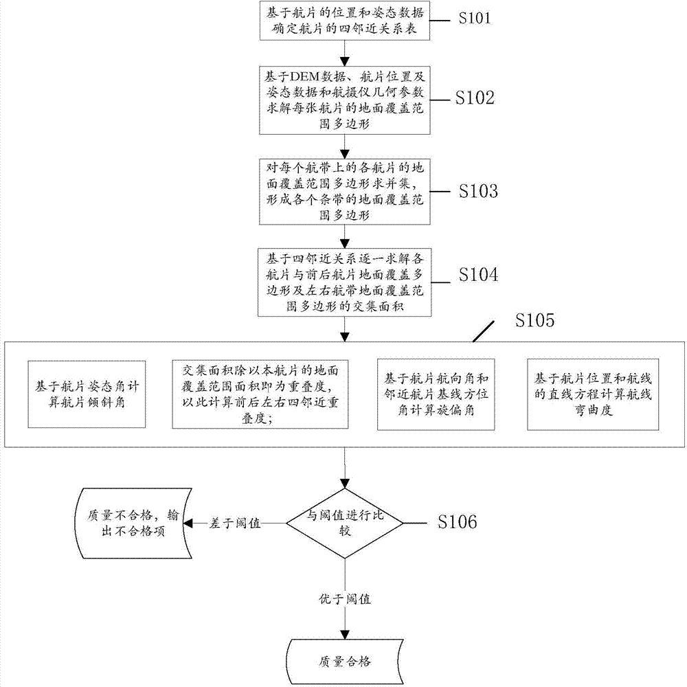
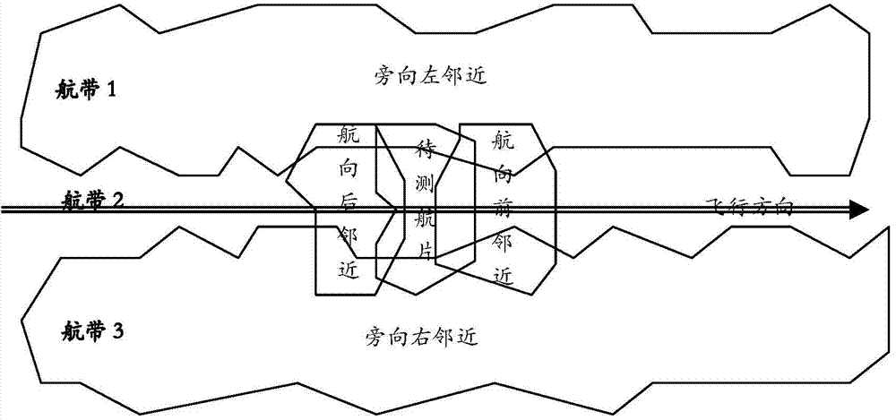
[0028] The embodiment of the present invention provides a method for inspecting the flight quality of aerial photography. Based on the position data, attitude data, geometric parameters of the aerial camera and digital elevation model (DEM) data of the aerial photograph, the collinear equation mathematical model is used to solve the problem of the aerial photograph. Ground coverage, based on the area intersection of the ground coverage, calculate...


PUM


Abstract

The invention discloses a checking method of aerophotography flight quality. The method can be applied to checking on flight quality of an area array aerial camera, and comprises the following steps of solving the ground coverage area of aerial photos based on position data, posture data, geometric parameters of an aerial camera and digital elevation model data of the aerial photos by virtue of a collinearity equation mathematical model; calculating and checking the lateral and heading overlap of the aerial photos based on the area intersection of the ground coverage range; and determining that the aerial photos meet the requirement when the flight quality checking item of the flight photos is within the threshold range stipulated by aerophotogrammetry specifications. According to the invention, a certain amount of points on the edge of an easel plane based on a collinearity equation are only required for calculation so as to generate a ground coverage range polygon of each aerial photo, and relevant operations of union, intersection and the like are carried out on the ground coverage range polygons; the calculation and checking of the overlap is based on the intersection area, and the calculating efficiency is high; for regular flight areas, the whole detecting area can be checked completely automatically, and thus the checking efficiency is improved.

Description

technical field [0001] The invention relates to the technical field of aerial photography, in particular to an aerial photography flight quality inspection method. Background technique [0002] Aerial photography flight quality inspection refers to checking the extent to which the flight route and image coverage of aerial photography meet the requirements. The aerial photography flight quality inspection items for area array aerial photography mainly include: aerial photo overlap, aerial photo deflection angle, aerial photo Angle of inclination and route curvature, etc.; nowadays, there are two modes of inspection of the aerial photography flight quality of the area array aerial camera. One is to conduct manual inspection in the industry based on aerial photographs. Using manual visual inspection or using a check ruler for quality inspection, this inspection mode is completely manual, time-consuming and labor-intensive, and requires personnel with strong inspection experienc...

Claims


Application Information

Patent Timeline
Patent Type & Authority Patents(China)
IPC IPC(8): G01C11/04
Inventor 赵海涛黎东回玉辉左正立张兵陈正超
Owner INST OF REMOTE SENSING & DIGITAL EARTH CHINESE ACADEMY OF SCI
Learn More