
Traffic flow surveying and handling method based on unmanned aerial vehicle high-definition video

A processing method, high-definition video technology, applied in traffic flow detection, road vehicle traffic control system, image data processing, etc. Investigating the effects of workload

Active Publication Date: 2013-11-27
SHENZHEN WISESOFT TECH DEV
View PDF9 Cites 64 Cited by
  • Summary
  • Abstract
  • Description
  • Claims
  • Application Information

AI Technical Summary

Problems solved by technology

[0002] Vehicle identification and tracking is an important content in intelligent transportation technology, and has broad application prospects in future traffic information collection and traffic control management; existing vehicle identification and tracking technology is mainly based on fixed camera video research, but fixed The camera is subject to shortcomings such as difficulty in movement and limited coverage, which greatly restricts its role in urban traffic monitoring.
However, the existing traditional investigation of traffic flow characteristics mainly adopts the method of separately investigating traffic volume, vehicle speed, density, etc., which not only requires a lot of manpower and material resources in the investigation process and data processing, but also interferes with the traffic to a certain extent. , The sample size of the survey is not large, and the survey process cannot be reproduced, etc.

Method used


Image

  • Traffic flow surveying and handling method based on unmanned aerial vehicle high-definition video
  • Traffic flow surveying and handling method based on unmanned aerial vehicle high-definition video
  • Traffic flow surveying and handling method based on unmanned aerial vehicle high-definition video

Examples


Embodiment 1

[0037] This example provides a traffic flow investigation and processing method based on UAV high-definition video, including the following steps:

[0038] In the video acquisition step, the drone hovers above the selected urban road intersection and shoots a high-definition video;

[0039] The image stabilization preprocessing step is to copy the high-definition video to the PC for image stabilization preprocessing and output the image sequence;

[0040] In the detection and tracking step, the image sequence after image stabilization is used as the source data to detect and track the moving object;

[0041] The analysis and statistics step is to analyze and count the traffic flow of the tracked target ID and current motion coordinates; and,

[0042] The output step is to transmit the statistical data of the traffic flow to the graphical interface of the client for display, and generate data and reports.

[0043] The workflow diagram of this example is as follows: figure 1 ...

Embodiment 2

[0048] On the basis of Embodiment 1, the image stabilization preprocessing steps described in this example include a series of steps: Step 1: Translate, rotate and scale the current frame image to make it the same as the previous frame image. First, look for severe jitter, scale down the image and calculate the displacement; then, double and quadruple the reduced image, fine-tune the displacement of these image blocks until the motion vectors (motion vectors) of the original image are found , and finally write the motion vectors to the log file. In step 2, the current frame image is translated, rotated and scaled according to the log file.

[0049] Both the detection and tracking steps and the analysis and statistics steps described in this example belong to the visual analysis, and specifically include the following five stages.

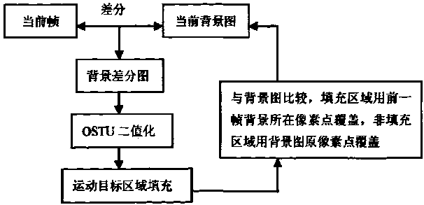
[0050] Stage 1: Use the fast median filter method to denoise the grayscale image. For the convenience of explanation, define each pixel in the 3 x...


PUM


Abstract

The invention provides a traffic flow surveying and handling method based on an unmanned aerial vehicle high-definition video. The method comprises the steps of video capture, wherein an unmanned aerial vehicle is made to hover over a selected urban road intersection for high-definition video shooting; image stabilization and pre-processing, wherein the high-definition video is copied, stabilization and pre-processing are carried out on images, and then an image sequence is output; detection and tracking, wherein detection and tracking are carried out on moving objects with the image sequence treated with image stabilization as source data; analysis and statistics, wherein traffic flow analysis and statistics are carried out on a target ID which is tracked down and the current coordinates of motion; output, wherein traffic flow statistical data are transmitted to a client-side graphical interface for display, and then data and statements are generated. The traffic flow surveying and handling method based on the unmanned aerial vehicle high-definition video is capable of obtaining various high-accuracy traffic data, reducing the workload of field survey remarkably, preventing the traffic from being affected, obtaining statistic data of all traffic flows in twelve directions of the intersection, and providing data support for congestion control such as intersection signal timing optimization and traffic channeling improvement.

Description

technical field [0001] The invention relates to a traffic flow investigation and processing method, in particular to a traffic flow investigation and processing method based on the high-definition video of an unmanned aerial vehicle. Background technique [0002] Vehicle identification and tracking is an important content in intelligent transportation technology, and has broad application prospects in future traffic information collection and traffic control management; existing vehicle identification and tracking technology is mainly based on fixed camera video research, but fixed The camera is subject to shortcomings such as difficulty in movement and limited coverage, which greatly restricts its role in urban traffic monitoring. However, the existing traditional investigation of traffic flow characteristics mainly adopts the method of separately investigating traffic volume, vehicle speed, density, etc., which not only requires a lot of manpower and material resources in ...

Claims


Application Information

Patent Timeline
IPC IPC(8): G08G1/065G08G1/01G06T7/00
Inventor 项芒潘大任许海波解军黄亚妮
Owner SHENZHEN WISESOFT TECH DEV
Learn More