Small low-altitude light area array laser radar measuring system
A measurement system, laser radar technology, applied in the direction of radio wave measurement system, measurement device, electromagnetic wave re-radiation, etc., to achieve the effect of reducing volume, size and weight, and improving use efficiency
- Summary
- Abstract
- Description
- Claims
- Application Information
AI Technical Summary
Problems solved by technology
Method used
Image
Examples
Embodiment
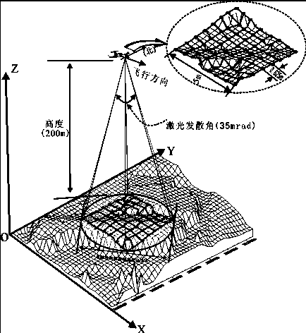
[0034] like figure 1 As shown in the working schematic diagram, the laser radar measurement system of this embodiment is carried on a 200m low-altitude small UAV for three-dimensional data acquisition. A single laser pulse can detect a target area of 5m×5m, and the distance error of the generated three-dimensional image is less than 0.12m, pixel pitch is 0.625m.
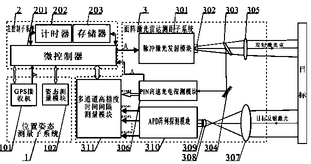
[0035] like figure 2 As shown, the low-altitude light and small area array lidar measurement system includes position and attitude measurement subsystem 1, main control subsystem 2 and area array lidar ranging subsystem 3.
[0036] The position and attitude measurement subsystem 1 is composed of a GPS receiver 101 and an attitude measurement module 102 .
[0037] The main control subsystem 2 is composed of a microcontroller 201 , a timer 202 and a memory 203 .
[0038] The area array lidar ranging subsystem 3 consists of a pulsed laser emitting module 301, a collimating lens 302, a beam splitter 303, a total re...
PUM
 Abstract
Description
Claims
Application Information
 - R&D
- Intellectual Property
- Life Sciences
- Materials
- Tech Scout
- Unparalleled Data Quality
- Higher Quality Content
- 60% Fewer Hallucinations
Browse by: Latest US Patents, China's latest patents, Technical Efficacy Thesaurus, Application Domain, Technology Topic, Popular Technical Reports.
© 2025 PatSnap. All rights reserved.Legal|Privacy policy|Modern Slavery Act Transparency Statement|Sitemap|About US| Contact US: help@patsnap.com


