
Synchronization assisting method compatible with global positioning system (GPS), Beidou 2 (BD2) and GLONASS system

An auxiliary synchronization and BD2 technology, applied in the transmission system, multi-frequency code system, radio transmission system, etc., can solve problems such as positioning result errors, achieve accurate and reliable positioning results, improve start-up speed and positioning accuracy, and improve utilization. Effect

Inactive Publication Date: 2013-03-20
ANHUI DAOYI ELECTRONICS TECH
View PDF5 Cites 8 Cited by
  • Summary
  • Abstract
  • Description
  • Claims
  • Application Information

AI Technical Summary

Problems solved by technology

In addition, due to the large error, the positioning result error based on this technology is also larger

Method used


Image

  • Synchronization assisting method compatible with global positioning system (GPS), Beidou 2 (BD2) and GLONASS system
  • Synchronization assisting method compatible with global positioning system (GPS), Beidou 2 (BD2) and GLONASS system
  • Synchronization assisting method compatible with global positioning system (GPS), Beidou 2 (BD2) and GLONASS system

Examples


Embodiment Construction

[0037] The method of the present invention and its implementation will be further described in detail below in conjunction with specific drawings and embodiments.

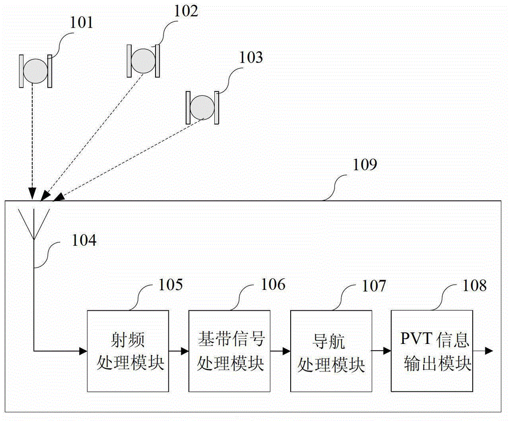
[0038] figure 1Shown is a block diagram of the global navigation satellite system GNSS. The GNSS receiver 109 includes an antenna 104 , a radio frequency processing module 105 , a baseband signal processing module 106 , a navigation processing module 107 and a PVT information output module 108 . The antenna 104 is connected to the radio frequency processing module 105 , the radio frequency processing module 105 is connected to the baseband signal processing module 106 , the baseband signal processing module 106 is connected to the navigation processing module 107 , and the navigation processing module 107 is connected to the PVT information output module 108 .

[0039] The antenna 104 receives the radio frequency signals from the satellite 101 of the GPS system, the satellite 102 of the BD2 system, and the satelli...


PUM


Abstract

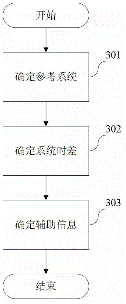
The invention discloses a synchronization assisting method compatible with a GPS, BD2 and a GLONASS system. The method comprises searching satellite systems, selecting appropriate reference satellites and determining reference information; processing the satellites needed to be assisted of the systems, and transforming the reference information to the assisted systems; and using the assisting information to assist synchronization; and modifying synchronization zone bits of assisted satellites to complete frame synchronization. According to the synchronization assisting method, satellites can be synchronized rapidly to participate in navigation processing immediately, and the performance and the efficiency of a receiver are improved effectively.

Description

technical field [0001] The invention relates to a synchronization method of a navigation satellite system, in particular to an auxiliary synchronization method compatible with GPS, BD2 and GLONASS systems. Background technique [0002] Global Navigation Satellite System (GNSS) provides users with positioning and navigation services, and has been widely used in consumer, transportation, electric power, national defense and other fields. GNSS includes the US Global Positioning System (GPS), Russia's GLONASS, EU's Galileo, China's Beidou system (BD2), and several other augmentation systems. [0003] The basic principle of GNSS receiver positioning is to receive the satellite signals of the above GNSS systems, use the navigation message transmitted by the satellite to calculate the satellite position, and use the ranging code (C / A code and / or P code) transmitted by the satellite to calculate the user arrival. The actual distance of the satellite including a certain deviation, t...

Claims


Application Information

Patent Timeline
Patent Type & Authority Applications(China)
IPC IPC(8): H04B7/185H04L27/26G01S19/13
CPCG01S19/30H04L27/26G01S19/33H04B7/185
Inventor 李尤何文涛翟昆朋蔺晓龙金亮良殷明
Owner ANHUI DAOYI ELECTRONICS TECH
Learn More