
Ground verification instrument of satellite-based marine radar height gauge

A radar altimeter and calibrator technology, applied in instruments, radio wave measurement systems, etc., can solve the problems of absolute calibration and performance inspection of spaceborne marine radar, and achieve the effect of eliminating influence

Inactive Publication Date: 2012-07-11
NAT SPACE SCI CENT CAS
View PDF4 Cites 16 Cited by
  • Summary
  • Abstract
  • Description
  • Claims
  • Application Information

AI Technical Summary

Problems solved by technology

[0008] The purpose of the present invention is to solve the problem that the existing technology cannot carry out absolute calibration and performance inspection on the ground before the launch of the spaceborne marine radar altimeter, thereby providing a ground calibration instrument for the spaceborne marine radar altimeter

Method used


Image

  • Ground verification instrument of satellite-based marine radar height gauge
  • Ground verification instrument of satellite-based marine radar height gauge
  • Ground verification instrument of satellite-based marine radar height gauge

Examples


Embodiment

[0063] The spaceborne marine radar altimeter ground verification instrument of the present invention is formed on the basis of a radar system and a radar echo simulator. For example, the structure of the transmitting unit and the receiving unit is the same as that of the related units in the echo simulator, and reference can be made to existing literature, which will not be repeated here.

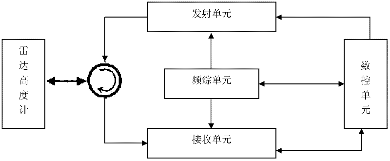
[0064] The ground calibration instrument of this embodiment includes: a transceiver control unit, a frequency synthesis unit, a timing unit and a numerical control unit, and each unit is specifically described as follows:

[0065] The transceiver control unit of the calibration instrument, the specific realization block diagram of the transceiver control unit of the spaceborne marine radar altimeter ground calibration instrument of the present invention is as follows Figure 4 As shown, the technical index example is shown in the table below, and the C frequency band is similar):

[0066] ...


PUM


Abstract

The invention provides a ground verification instrument of a satellite-based marine radar height gauge, which is used for performing absolute calibration, performance examination and function test on the satellite-based marine radar height gauge in a laboratory. The ground verification instrument of the satellite-based marine radar height gauge comprises a time service unit, a transceiving control unit, a transmitting unit, a receiving unit, a frequency heald unit and a numerical control unit. The frequency heald unit utilizes an ultra-stable crystal oscillator signal provided by a radar height gauge to be verified as a clock. The time service unit takes charge of providing accurate synchronous time service for the numerical control unit and the radar height gauge. The transceiving control unit takes charge of respectively and simultaneously sending signals transmitted by the transmitting unit to the receiving unit and the radar height gauge and also controlling the receiving unit to receive the signals transmitted by the radar height gauge or the signals transmitted by the transmitting unit. The numerical control unit takes charge of eliminating channel influences of a verification instrument system, generating calibration signals, simulating echo signals of various target scenes and controlling the transceiving control unit, the receiving unit, the transmitting unit and the frequency heald unit.

Description

technical field [0001] The invention relates to a ground laboratory calibration, performance inspection and function test system for a space-borne ocean radar altimeter before launch, in particular to a ground calibration instrument for a space-borne ocean radar altimeter. Background technique [0002] The spaceborne ocean radar altimeter is a very important ocean microwave remote sensor, which can accurately measure the global average sea surface height, and the accuracy of the measurement can reach the order of centimeters. With the development of microwave remote sensing technology in recent years, the measurement of the mean sea level by the spaceborne marine radar altimeter can reach 2 cm under the condition of 2 m effective wave height and 1 second average. The design index of my country's first spaceborne marine radar altimeter, which was launched in August 2011, is 4 cm. Since the principle of the space-borne ocean radar altimeter is to calculate the distance betwee...

Claims


Application Information

Patent Timeline
IPC IPC(8): G01S7/40
Inventor 杨双宝刘和光徐曦煜
Owner NAT SPACE SCI CENT CAS
Learn More