
A Method of Simulating Urban Expansion Based on Spatial Function Division

A technology of spatial function and urban expansion, applied in the field of simulated urban expansion, it can solve problems such as thin spatial constraints and inability to fully express spatial information.

Inactive Publication Date: 2011-12-21
WUHAN UNIV
View PDF3 Cites 15 Cited by
  • Summary
  • Abstract
  • Description
  • Claims
  • Application Information

AI Technical Summary

Problems solved by technology

Although a CA model based on subregions is proposed, the regional division of this model is too simple, and the spatial constraints are weak. It only considers the simple division of important traffic lines on the region, and cannot fully express the spatial information.

Method used


Image

  • A Method of Simulating Urban Expansion Based on Spatial Function Division
  • A Method of Simulating Urban Expansion Based on Spatial Function Division
  • A Method of Simulating Urban Expansion Based on Spatial Function Division

Examples


Embodiment Construction

[0075] The advantages of the technical solution of the present invention will be further described below in conjunction with the accompanying drawings.

[0076] A method for simulating urban expansion based on spatial function division, comprising the following steps:

[0077] 1) Division of urban space function areas

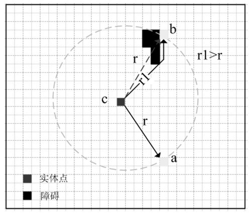
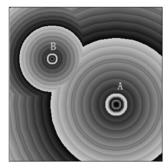
[0078] 1-1 Use Hu Peng's map algebra method to measure the spatial distance from the spatial entity to the city center:

[0079] When simulating urban expansion, the primary problem is to correctly measure urban space in order to more accurately reflect the spatial relationship and the interaction of spatial entities. In practical applications, it is often necessary to measure location characteristics, such as the distance from the spatial entity to the city center, the distance from the spatial entity to the railway, and so on. Traditional measurement methods often use Euclidean distance to measure two-dimensional Euclidean space. This measurement method ign...


PUM


Abstract

The invention discloses a method for simulating urban expansion based on the division of spatial functions. The method of the invention fully considers the widespread existence of obstacles in urban expansion, the existence of multi-space entities, and the different modes of action of each entity. Heterogeneity features reasonably divide urban space, define the spatial function of different morphological entities, and construct reasonable conversion rules for each region. The process of urban expansion can be more realistically simulated by adopting the method of the invention.

Description

technical field [0001] The invention relates to a method for simulating urban expansion, in particular to a method for simulating urban expansion based on spatial function division. Background technique [0002] On the basis of the basic theory of cellular automata (CA for short), many scholars have coupled new methods to produce a variety of urban expansion application models. Zhou Chenghu et al. 错误!未找到引用源。 Proposed Urban Dynamic Evolution (GeoCA-Urban) model; Lixia et al. 错误!未找到引用源。 Proposed Neural Network Cellular Automata (ANN-CA) model; Yang Liangjie et al. [3] Proposed object-based urban evolution (GeoObject-Urban) model. These studies have greatly enriched and expanded the CA application model, but they have ignored the regional heterogeneity of urban space and cannot break through the limitation of the singleness of CA evolution rules. 错误!未找到引用源。 . The construction of these model conversion rules is "static" and "holistic", that is, the conversion rules act on th...

Claims


Application Information

Patent Timeline
IPC IPC(8): G06F19/00G06N3/00
Inventor 王海军贺三维张文婷何青青
Owner WUHAN UNIV
Learn More