
Method for obtaining field evapotranspiration of field scale

A technology for evapotranspiration and farmland, applied in special data processing applications, instruments, electrical digital data processing, etc., can solve problems such as insufficient reflection of crop evapotranspiration trends, inability to obtain farmland evapotranspiration, and low resolution.

Active Publication Date: 2011-07-27
BEIJING RES CENT FOR INFORMATION TECH & AGRI
View PDF2 Cites 11 Cited by
  • Summary
  • Abstract
  • Description
  • Claims
  • Application Information

AI Technical Summary

Problems solved by technology

Medium and high-resolution remote sensing data are suitable for small-scale research in the field, and can better reflect the flux differences between different crops, but their time resolution is too low (about half a month), and when there are cloudy and rainy days It takes more than one month to obtain a remote sensing image, and the cost of obtaining images is high, so it is difficult to obtain time series data, which is not enough to reflect the trend of evapotranspiration in the crop growing season
Low- and medium-resolution remote sensing data have good regional and timeliness, and can cover a large area of ​​the earth's surface in a short period of time, which is very important for drought monitoring and climate change research. Due to the calculation error caused by the mixed pixels caused by the low spatial resolution and the non-uniformity of the ground surface, it faces serious scale problems in practical applications.
[0003] The existing thermal infrared remote sensing data that can be used for evapotranspiration estimation has low spatial resolution (high temporal resolution), and there are a large number of mixed pixels, which makes it impossible to obtain field-scale (hectare-level) farmland evapotranspiration
At present, it is difficult to calculate field-scale farmland evapotranspiration using thermal infrared remote sensing data: (1) Due to the low spatial resolution of existing thermal infrared remote sensing data, it is impossible to obtain the size of field-scale (ha-level) farmland evapotranspiration; (2) lack of A method of combining low spatial resolution thermal infrared remote sensing data with visible light remote sensing data for sub-pixel temperature calculation; (3) lack of algorithms for calculating farmland evapotranspiration based on remote sensing data

Method used


Image

  • Method for obtaining field evapotranspiration of field scale
  • Method for obtaining field evapotranspiration of field scale
  • Method for obtaining field evapotranspiration of field scale

Examples


Embodiment Construction

[0043] The specific implementation of the present invention will be further described in detail below in conjunction with the drawings and embodiments. The following examples are used to illustrate the present invention, but not to limit the scope of the present invention.

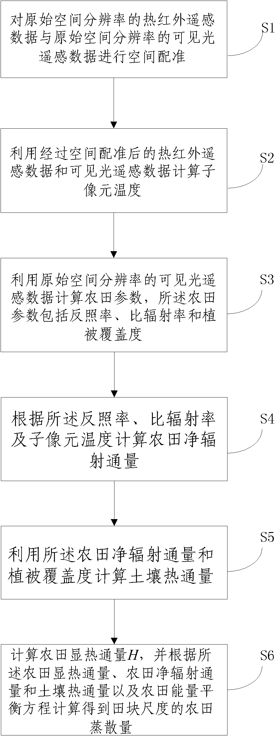
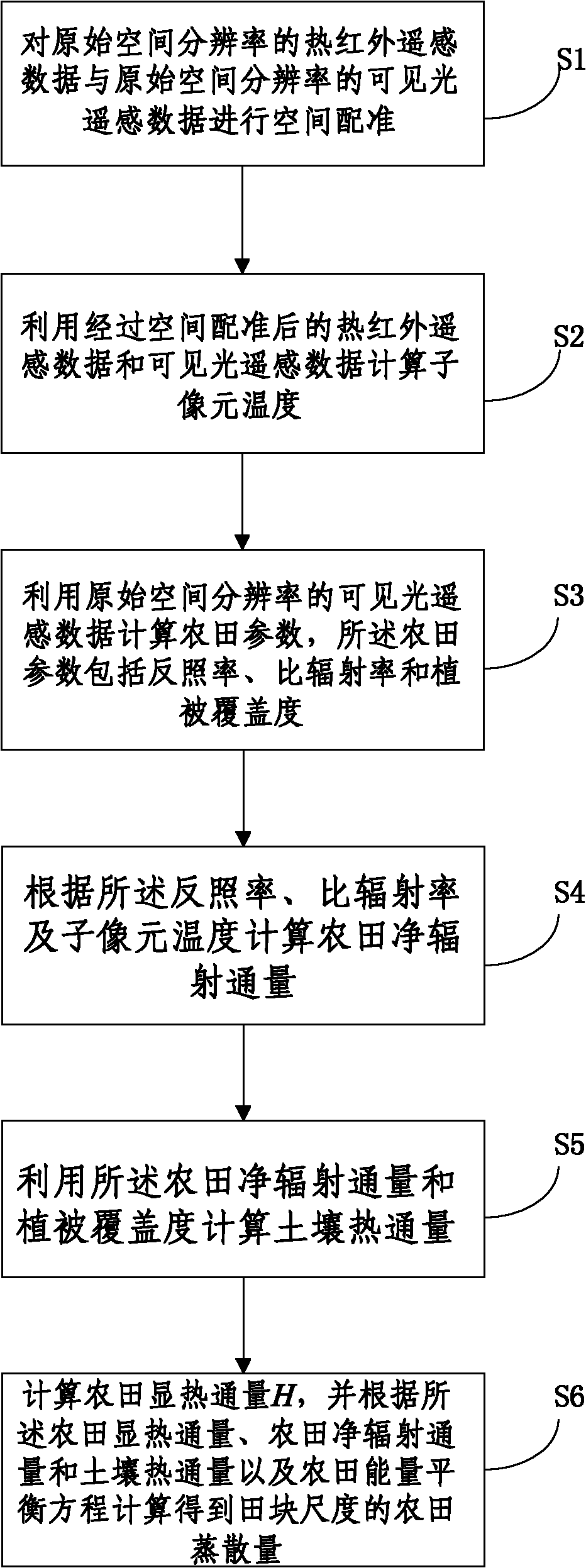
[0044] figure 1 It is a flowchart of the method of the present invention. The present invention proposes a method for obtaining field-scale farmland evapotranspiration including the following steps:

[0045] S1. Spatial registration of thermal infrared remote sensing data and visible light remote sensing data.

[0046] In order to be able to simultaneously use the two remote sensing data in the same area for field-scale farmland evapotranspiration calculations, the geographic projection methods and spatial corresponding ranges of the two must be uniformly converted, so that the two pixels are completely overlapped in space. . Select the high spatial resolution visible light remote sensing data geographic proj...


PUM


Abstract

The invention discloses a method for obtaining field evapotranspiration of field scale, comprising the following steps: S1. space registration is carried out to thermal infrared remote sensing data of original spatial resolution and visible light remote sensing data of the original spatial resolution; S2. sub-pixel temperature is calculated by utilizing the thermal infrared remote sensing data and the visible light remote sensing data whichare treated with space registration; S3. field parameters including albedo, specific emittance and vegetation coverage are calculated by utilizing the visible light remote sensing data of the original spatial resolution; S4. the field net radiation flux is calculated according to the albedo, the specific emittance and the sub-pixel temperature; S5. soil heat flux is calculated by utilizing the field net radiation flux and the vegetation coverage; and S6. the field sensible heat flux H is calculated, and the field evapotranspiration of the field scale can be calculated according to the field sensible heat flux, the field net radiation flux, the soil heat flux and field energy equilibrium equation. By adopting the method in the invention, the field evapotranspiration of the field scale can be obtained.

Description

Technical field [0001] The invention relates to the technical field of hydrology and meteorology, in particular to a method for obtaining farmland evapotranspiration at a field scale. Background technique [0002] Farmland evapotranspiration is the sum of crop transpiration and soil evaporation between trees. It is the main expenditure item of farmland water balance. It is an important basis for planning water storage and water supply, designing drought prevention and drought resistance measures, etc. It is important to identify crop water supply conditions index. However, due to the spatial heterogeneity of farmland, traditional atmospheric or hydrological observation methods can only obtain the evapotranspiration at a single point location, and cannot obtain a continuous spatial distribution of evapotranspiration. Compared with the above-mentioned traditional observation methods, remote sensing has the advantages of dynamic and large-scale coverage. Using remote sensing to mon...

Claims


Application Information

Patent Timeline
IPC IPC(8): G06F19/00G01N25/20
Inventor 杨贵军黄文江赵春江王纪华李存军宋晓宇徐新刚顾晓鹤杨小冬陈红
Owner BEIJING RES CENT FOR INFORMATION TECH & AGRI
Learn More