Method for judging whether vehicle deviates from planned route through route region

A technology for predetermined routes and vehicles, applied in satellite radio beacon positioning systems, radio wave measurement systems, instruments, etc., to solve problems such as low processing efficiency, inconvenient use, and complexity

Inactive Publication Date: 2011-05-18
XIAMEN YAXON NETWORKS CO LTD
View PDF6 Cites 31 Cited by
  • Summary
  • Abstract
  • Description
  • Claims
  • Application Information

AI Technical Summary

Problems solved by technology

For most mobile terminals with limited processing capacity, such an operation proce...

Method used


Image

  • Method for judging whether vehicle deviates from planned route through route region
  • Method for judging whether vehicle deviates from planned route through route region
  • Method for judging whether vehicle deviates from planned route through route region

Examples


Embodiment Construction

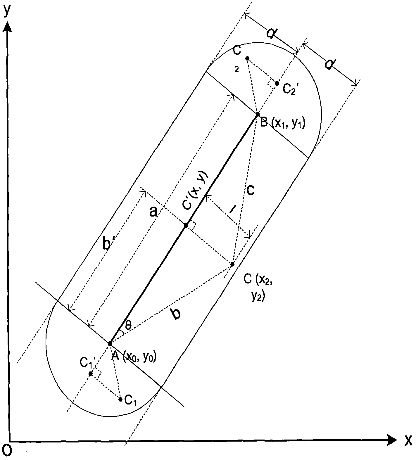
[0047] Such as figure 1 As shown in , the route is composed of several location points, each two adjacent points determine a road segment, and each road segment corresponds to a route width, and each road segment contains such as figure 1 The area colored gray in , which consists of individual road segment areas that make up the route area.

[0048] Let A and B be the two endpoints of a road section on the route, the distance between A and B is not too large (relative to the surface of the earth), the latitude and longitude are converted into a unified unit, and the two points A and B are not close The poles of the earth can be approximated by placing the two points A and B in a Cartesian coordinate system, where the x-axis represents the direction of longitude change, and the y-axis represents the direction of latitude change. The coordinates of A and B points can be expressed as A(x 0 ,y 0 ), B(x 1 ,y 1 ), where x and y are signed numbers, positive for east longitude and...


PUM


Abstract

The invention discloses a method for judging whether a vehicle deviates from a planned route through a route region. When the vehicle is running, a global positioning system (GPS) module in a mobile terminal periodically outputs position information on way-points of the vehicle to a microprocessor control unit (MCU), and the MCU calculates the distances between the way-points of the vehicle and each reference point on the route; when the distance is polled to be smaller than a threshold value reference point, the distances from the way-points to road sections determined by each adjacent point in the reference points are calculated one by one, and if one of the distances of these road sections is not more than the road section width corresponding to the road section, the way-points of the vehicle are considered to be positioned in the route area; otherwise, if all the distances of these road sections are more than the road section width corresponding to the road sections, the way-points of the vehicle are considered to be positioned outside the route area, and the vehicle is judged to deviate from the planned route. The method has a simple and convenient operation processing process, a high efficiency and equivalent accuracy, so the method is particularly suitable for mobile terminals with limited operation processing capacity.

Description

technical field [0001] The invention belongs to the field of satellite positioning and monitoring, and relates to a method for judging whether a vehicle passing point deviates from a predetermined route through a route area based on latitude and longitude. Background technique [0002] With the development of GPS industry applications, some special vehicles, such as hazardous chemical transport vehicles, buses, bank escort vehicles, etc., need to plan their driving routes in advance and monitor and manage them in real time. Therefore, various ways of expressing routes based on GIS maps and methods for judging whether the vehicle is traveling according to the predetermined route have emerged as the times require. [0003] Common representations of route areas are: [0004] 1. Use several points to form an irregular polygonal route area; [0005] 2. Use several parallelograms represented by points, slopes and widths to form the route area; [0006] 3. Use several points on ...

Claims


Application Information

Patent Timeline
IPC IPC(8): G01S19/39G01S19/42
Inventor 黄运峰叶德焰陈挺蔡运文赖荣东
Owner XIAMEN YAXON NETWORKS CO LTD
Why Eureka
Try Eureka