Multi-scale segmentation method for remote sensing image with boundary maintenance characteristics
A remote sensing image, multi-scale technology, applied in the field of remote sensing image processing, can solve problems such as positioning errors, achieve accurate positioning and inspection, and effectively maintain the effect of ground object boundaries
- Summary
- Abstract
- Description
- Claims
- Application Information
AI Technical Summary
Problems solved by technology
Method used
Image
Examples
Embodiment Construction
[0036] The present invention will be further described in detail through the embodiments below in conjunction with the accompanying drawings.
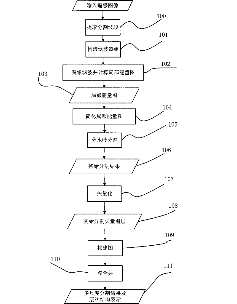
[0037] The implementation process of the boundary-preserving remote sensing image segmentation method of the present invention is as follows: figure 1 as shown, figure 1 Consists of 12 units. The graph merging in this embodiment will be described by taking the Boruvka algorithm of the minimum spanning tree as an example.
[0038] Unit 100 is an extraction split-band unit. Remote sensing images, especially multispectral images, usually have more than three bands. However, image segmentation is often performed on a band, so it is necessary to extract the band to be segmented. For the panchromatic band, it can be segmented directly in this band; for the multi-spectral band, select one of the bands or segment on the combined image of the bands, or segment on the component after spectral transformation, such as the first component after...
PUM
 Abstract
Description
Claims
Application Information
 - R&D
- Intellectual Property
- Life Sciences
- Materials
- Tech Scout
- Unparalleled Data Quality
- Higher Quality Content
- 60% Fewer Hallucinations
Browse by: Latest US Patents, China's latest patents, Technical Efficacy Thesaurus, Application Domain, Technology Topic, Popular Technical Reports.
© 2025 PatSnap. All rights reserved.Legal|Privacy policy|Modern Slavery Act Transparency Statement|Sitemap|About US| Contact US: help@patsnap.com


