
Map control based on Google Maps JavaScript API and production method thereof

A map and map editing technology, applied in the field of communication, can solve the problems of data incompatibility, poor results, energy consumption, etc., and achieve the effect of lowering the threshold

Inactive Publication Date: 2011-04-20
ZTE CORP
View PDF2 Cites 6 Cited by
  • Summary
  • Abstract
  • Description
  • Claims
  • Application Information

AI Technical Summary

Problems solved by technology

But in fact, spatial data is often expensive and incompatible, and the traditional GIS (Geographic Information System, geographic information system) platform is often complicated and difficult to use, which makes more than half of the investment in building a GIS system spent on data Most of the energy is spent on dealing with those difficult-to-use GIS platforms
The final result is a lot of investment in GIS projects, but the results are not good

Method used


Image

  • Map control based on Google Maps JavaScript API and production method thereof
  • Map control based on Google Maps JavaScript API and production method thereof
  • Map control based on Google Maps JavaScript API and production method thereof

Examples


Embodiment Construction

[0033] The technical solutions of the present invention will be further described below in conjunction with the accompanying drawings and specific embodiments. It should be understood that the specific embodiments described here are only used to explain the present invention, not to limit the present invention.

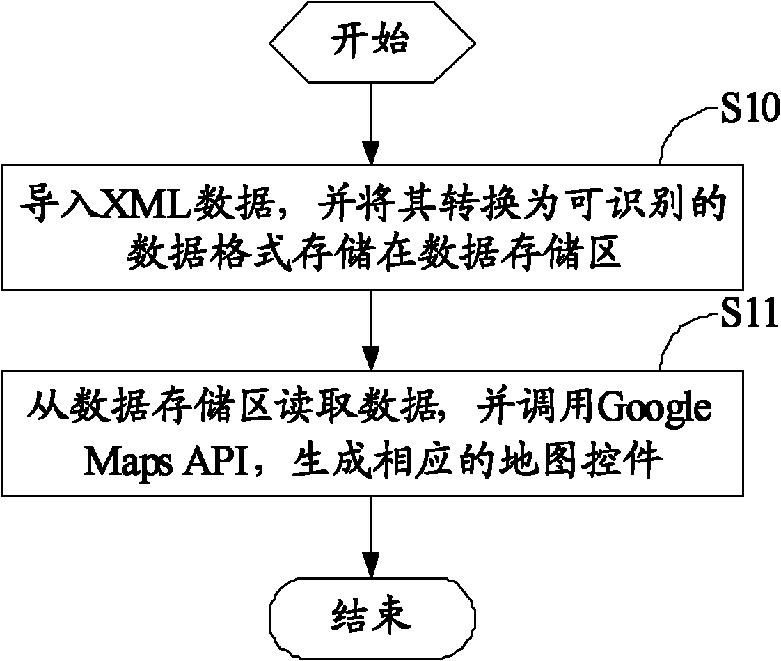
[0034] figure 1 It is a schematic flowchart of an embodiment of the method for generating a map control based on Google Maps JavaScript API in the present invention.

[0035] The present embodiment is based on the map control generation method of Google Maps JavaScript API, comprises the following steps:

[0036] Step S10, import the XML data, and convert it into a recognizable data format and store it in the data storage area;

[0037] Step S10 specifically includes: importing XML data from the XML (Extensible Markup Language) file data loading interface or background service data loading interface, and converting it into a recognizable data format and storing it i...


PUM


Abstract

The invention relates to a map control based on Google Maps JavaScript API and production method thereof. The production method comprises the following steps: introducing XML data file; and converting into recognizable data format to store in a data storage area; reading data from the data storage area, and invokeing Google Maps API to generate corresponding map control. The threshold of using Google electronic map service by a service system can be lowered by utilizing the invention, and application based on Google Maps can be rapidly developed; furthermore, the developer can invoke the function and service of the Google Maps only by outputting the data according to a fixed data exchange format without researching the use of Google Maps.

Description

technical field [0001] The invention relates to the communication field, in particular to a Google Maps JavaScript API-based map control and a generating method thereof. Background technique [0002] Applications based on spatial data require two major supports, the first is data; the second is the platform. But in fact, spatial data is often expensive and incompatible, and the traditional GIS (Geographic Information System, Geographic Information System) platform is often complicated and difficult to use, which makes more than half of the investment in building a GIS system spent on data On the Internet, most of the energy is spent on dealing with those difficult-to-use GIS platforms. The final result is that there is a lot of investment in GIS projects, but the results are not good. [0003] With the development of the Internet, network electronic maps have become an important field of Internet applications, and the Internet electronic map industry is also developing at ...

Claims


Application Information

Patent Timeline
IPC IPC(8): G06F9/44G06F17/30
Inventor 杨汉波
Owner ZTE CORP
Learn More