GPS airborne target geolocating method

a geolocation method and target technology, applied in the direction of astronomical navigation, instruments, navigation by means of navigation, etc., can solve the problems of unsuitable cloudy environs, high cost of star trackers, and inaccurate geolocation, so as to improve the geolocation accuracy of targets and high accuracy of targeting

Inactive Publication Date: 2007-05-08
THE AEROSPACE CORPORATION
View PDF3 Cites 0 Cited by
  • Summary
  • Abstract
  • Description
  • Claims
  • Application Information

AI Technical Summary

Benefits of technology

[0013]The invention is directed to a method for relative GPS navigation and targeting. Using a precise GPS relative positioning method, a beacon from an overflying aircraft can be used to reference boresight pointing angles of low altitude airborne sensors for significantly improving the geolocation accuracy of the target relative to low altitude sensor platforms. The high altitude vehicle is a beacon platform for providing the beacon as a reference. The low altitude vehicle is a sensor platform for imaging the beacon and for imaging the target. The beacon sensor and target sensor preferably have common aligned boresights for accurate imaging of the beacon relative to the target. The beacon platform and sensor platform use the same four GPS satellites for respective GPS position determinations. Both the beacon platform position and sensor platform position have approximately the same GPS positioning errors that cancel out in the relative GPS navigation solution, so that the relative GPS positioning error between two GPS navigation solutions is small. As such, precise offsets provided by relative GPS navigation provides highly accurate targeting. The sensor platform can determine the relative GPS location and precise target location for accurately guiding a maneuvering payload toward the target location.

Problems solved by technology

Targeting sensors using infrared sensing and mounted on unmanned vehicles have about a one foot resolution from about 5000 feet altitude but suffer from geolocation errors that may be as high as 100 feet due to poor altitude determinations.
Star trackers could be adapted for low altitude unmanned vehicular operations, but star trackers are expensive and operationally complex, and unsuitable for cloudy environs.
As such, star tracking may not always be suitable as a means for attitude determination for low altitude unmanned vehicles.
Though widely employed, stationary beacons are not often suitable for calibrating the boresight pointing angles of aircraft-based sensors.
Also, it may not always be feasible at times to place ground beacons close to targets of interest.
Such seekers may require risky proximal release from a mother vehicle.
However, a maneuvering payload using conventional GPS navigation can not achieve a miss distance that is sufficiently accurate for miniature bombs.
The field of view of the seeker is a limiting factor at very short acquisition ranges in the presence of high lateral acceleration capability.
Conventional seekers with associated guidance processors have expensive precision optical components for guidance control for reducing the target geolocation errors that can presently resolve fine features such as windshields or exhaust pipes of moving vehicles.
Hence, present geolocating and targeting systems do not provide inexpensive yet highly accurate homing seekers.

Method used


Image

  • GPS airborne target geolocating method
  • GPS airborne target geolocating method
  • GPS airborne target geolocating method

Examples


Embodiment Construction

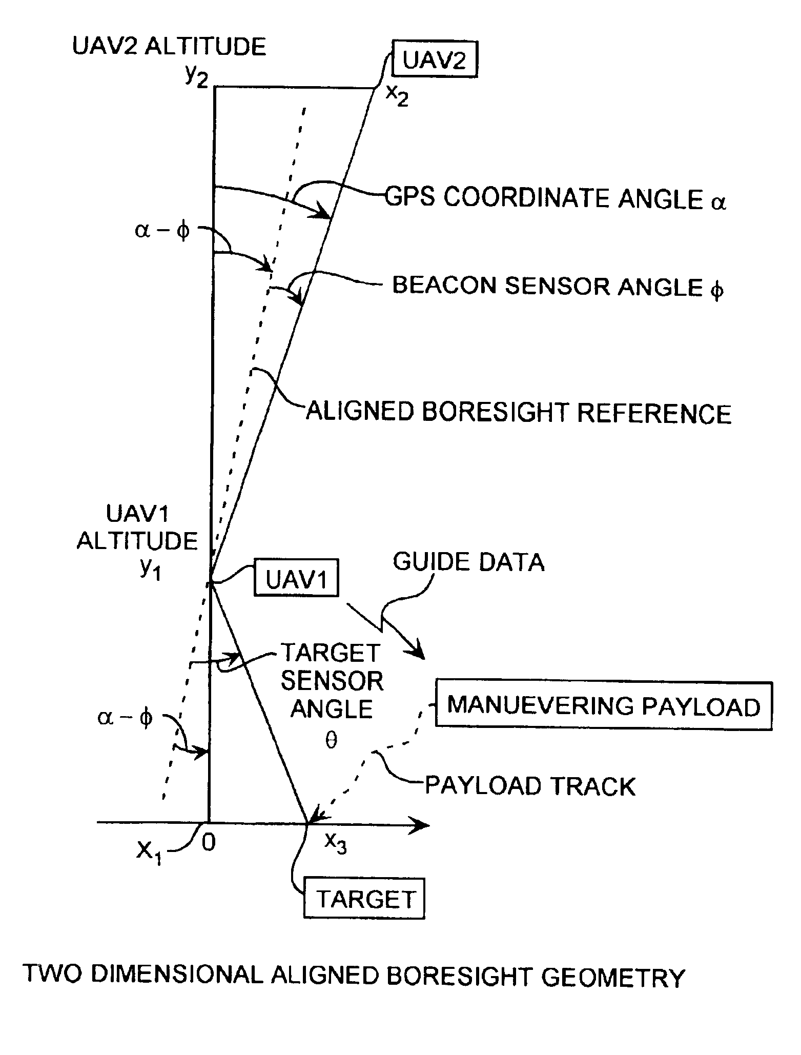
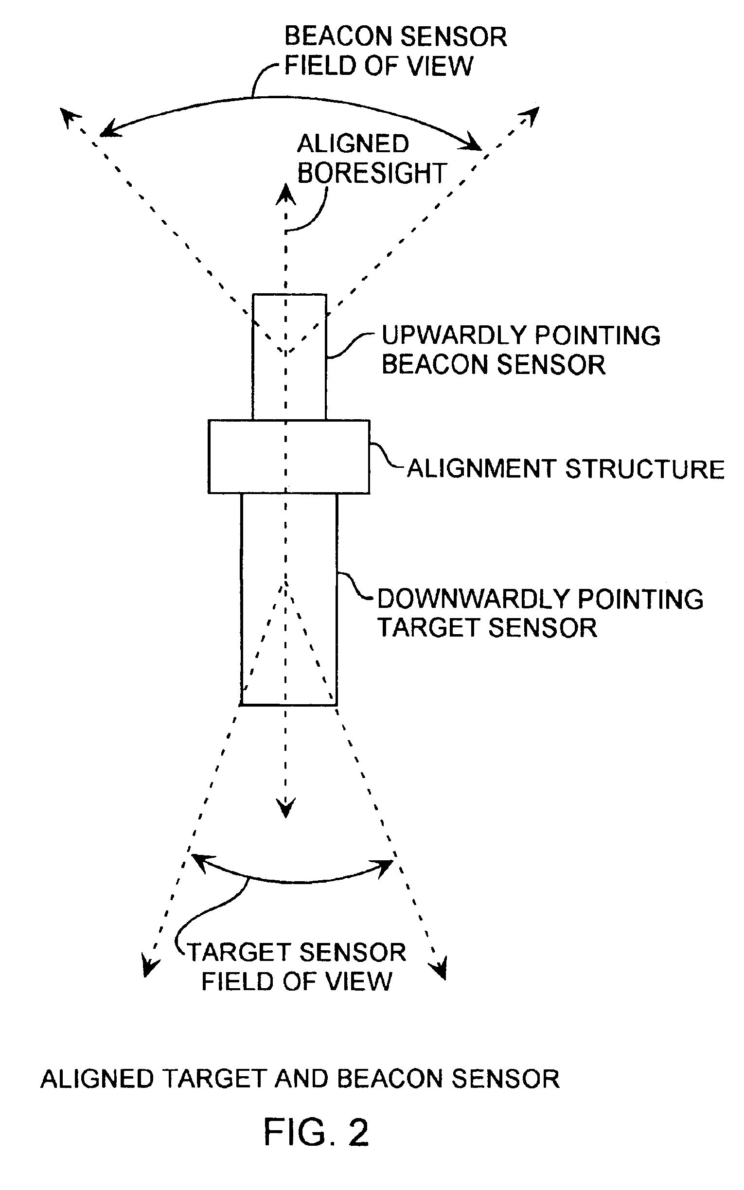
[0018]An embodiment of the invention is described with reference to the figures using reference designations as shown in the figures. Referring to FIGS. 1 and 2, many systems implementations can practice the method, including a GPS artificial star airborne boresighting system. The preferred system implementation includes an acquisition unmanned airborne vehicle UAV1 at a y1 low altitude relative to an x1=0 horizontal reference, and a beacon unmanned airborne vehicle UAV2 at a high altitude y2, at an x2 horizontal position. The UAV1 is a sensor platform and the UAV2 is a beacon platform. The UAV1 preferably includes a target and beacon sensor assembly as shown in FIG. 2, a GPS receiver, and two-way communication equipment, both not shown. The UAV2 preferably includes a steerable beacon generator, for providing a beacon, a GPS receiver, and two-way communication equipment, all not shown. GPS receivers and two-way communication equipment are well known.

[0019]The downwardly pointing tar...


PUM


Abstract

A geolocation method is applied for accurate targeting of a target using an airborne beacon as a pseudo star generated by a high altitude vehicle, and using optical sensors by a low altitude vehicle for imaging the beacon and target for generating accurate relative GPS positioning of the target for improved the geolocation of the target preferably for precise delivery of a payload to the target. The method is applicable to military and civilian needs for accurate delivery of a payload to a target, such as for precise delivery of humanitarian aid or weapon munitions.

Description

STATEMENT OF GOVERNMENT INTEREST[0001]The invention was made with Government support under contract No. F04701-93-C-0094 by the Department of the Air Force. The Government has certain rights in the invention.FIELD OF THE INVENTION[0002]The invention relates to the field of guided airborne payloads and geolocation methods used by airborne vehicles. More particularly, the present invention relates to reference beacon geolocation methods by airborne beacon reference vehicles cooperating with airborne target-geolocating unmanned vehicles.BACKGROUND OF THE INVENTION[0003]Stationary beacons, such as stars or ground-based reflectors, optical beams, and radar transponders, are commonly used as geolocation references. Examples of stationary-beacon geolocating systems includes split-field and star reference systems. Split-field reference attitude systems superimpose star images on photographs of ground objects. With knowledge of the latitude and longitude of the sensor platform and the time o...

Claims


Application Information

Patent Timeline
Patent Type & Authority Patents(United States)
IPC IPC(8): G01C21/00G01S19/10G01S1/70G01S5/14G01S5/16G01S19/21G01S19/46
CPCG01S5/0284G01S5/16G01S19/10G01S19/46G01S1/7032
Inventor SMITH, PATRICK LAWRENCE
Owner THE AEROSPACE CORPORATION
Why Eureka
Try Eureka