
Scalable and efficient cutting of map tiles

a map tile and efficient technology, applied in the field of map tile scaling and efficient cutting, can solve the problems of wasting memory space, unable to keep track of all those roads, and features of a geographical area that are too small to be represented on a map at some particular scale, so as to reduce the amount of data

Active Publication Date: 2016-07-19
APPLE INC
View PDF33 Cites 1 Cited by
  • Summary
  • Abstract
  • Description
  • Claims
  • Application Information

AI Technical Summary

Benefits of technology

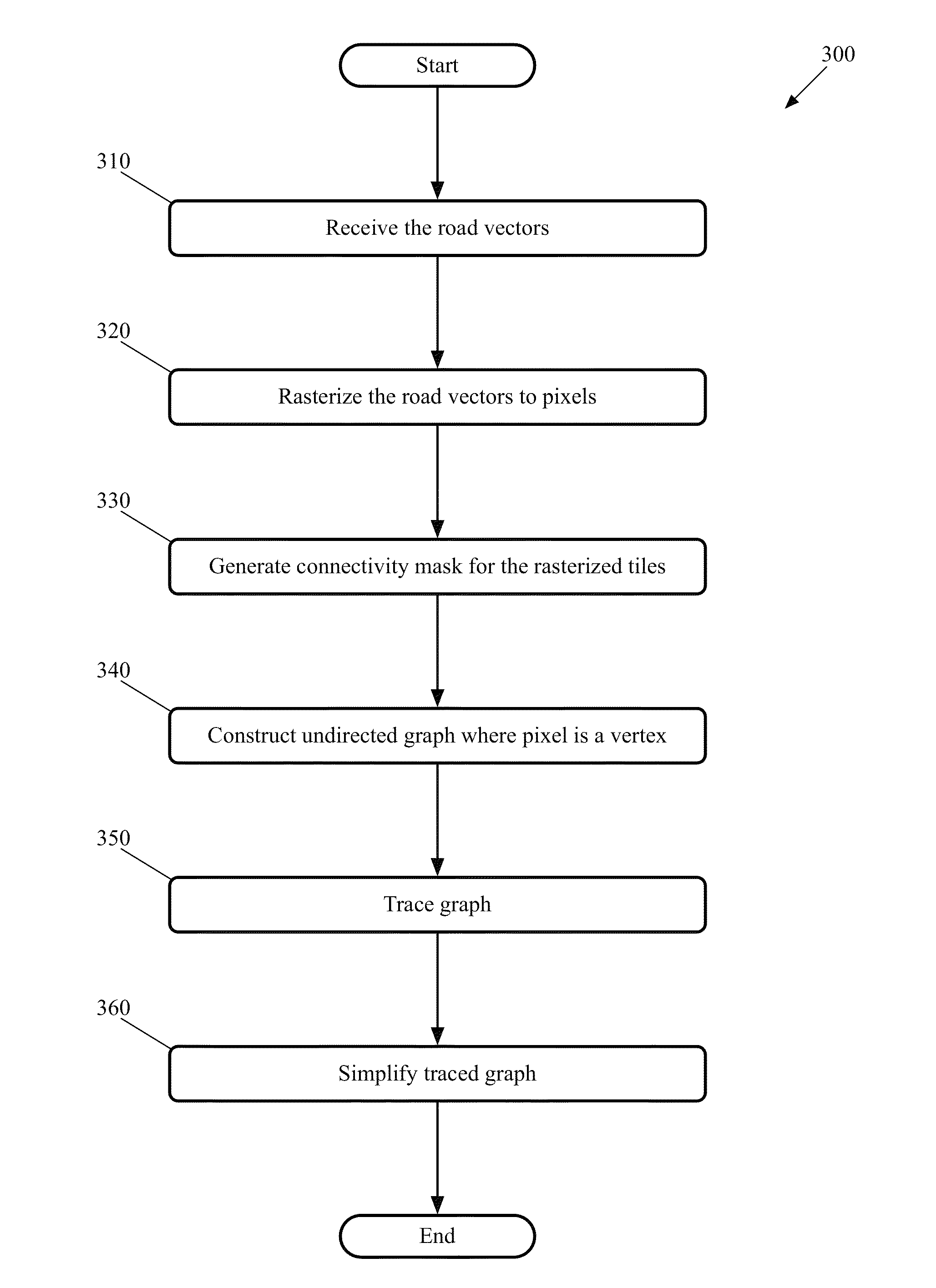
[0005]Some embodiments use a process that reduces the amount of data for a tile that could not be displayed separately on the scale of that tile. The process of some embodiments generates an equivalent of the road data by: (1) rasterizing the vectors representing road segments lying within a tile, (2) generating a connectivity mask for the tile(s). The connectivity mask keeps track of which pixels are connected to which other pixels along the vectors so that, e.g., two adjacent pixels representing parts of different roads are treated differently than two adjacent pixels representing parts of the same road. The process further (3) constructs an undirected graph. Each “on” pixel of the undirected graph represents a vertex and the vertices are connected by edges generated from the connectivity graph, but without a set direction (e.g., a north-south edge does not differentiate whether the original road direction was north or south). The process then (4) traces the undirected graph to generate chains of connected road segments and (5) takes the chains of connected road segments and simplifies them in order to reduce the amount of data that must be stored and transmitted for the tile in order to produce all the visible roads of the tile at that scale.

Problems solved by technology

However, some features of a geographical area may be too small to be represented on a map at some particular scale.
As those road segments would cover the same pixel, keeping track of all those roads at that scale would be a waste of memory space on the servers that store the map tile.
Additionally, sending such redundant information would use up potentially expensive bandwidth.
Furthermore, processing the information in its eventual use with a mapping application on a device would also be more complicated.
Similar problems arise for other relatively small features (e.g., two small parks within a real world distance of 100 meters in a 100 km to a side tile).

Method used


Image

  • Scalable and efficient cutting of map tiles
  • Scalable and efficient cutting of map tiles
  • Scalable and efficient cutting of map tiles

Examples


Embodiment Construction

[0027]In the following detailed description of the invention, numerous details, examples, and embodiments of the invention are set forth and described. However, it will be clear and apparent to one skilled in the art that the invention is not limited to the embodiments set forth and that the invention may be practiced without some of the specific details and examples discussed.

[0028]Map tiles are used in some embodiments to present 3D map presentations for browsing and navigation on a client device. In some embodiments, the client device (e.g., a mobile device) has a touch-sensitive screen and a multi-touch interface that allow a user to interact with the presentations through touch and gestural inputs on the screen. In other embodiments, the presentations are provided on a device that does not have a touch-sensitive screen. In some embodiments described below, these 3D presentations are provided by an integrated mapping application that provides several useful modalities, such as l...


PUM


Abstract

A process is provided that reduces the amount of data for a map tile that could not be displayed separately on the scale of that tile. The process generates an equivalent of the road data by rasterizing the vectors representing road segments lying within a tile and generating a connectivity mask that keeps track of which pixels are connected to which other pixels along the vectors. The process constructs an undirected graph. Each “on” pixel of the undirected graph represents a vertex and the vertices are connected by edges generated from the connectivity graph, but without a set direction. The process traces the undirected graph to generate chains of connected road segments and takes the chains and simplifies them in order to reduce the amount of data that must be stored and transmitted for the tile in order to produce all the visible roads of the tile at that scale.

Description

CLAIM OF BENEFIT TO PRIOR APPLICATIONS[0001]This Application claims the benefit of U.S. Provisional Application 61 / 657,872, entitled “Scalable and Efficient Cutting of Map Tiles,” filed Jun. 10, 2012. U.S. Provisional Application 61 / 657,872 is herein incorporated by reference.BACKGROUND[0002]Computerized map programs allow a user to view a great deal of data. Some applications allow a client device to download map data that encompasses any location in the world at a detailed level. Such applications entail enormous quantities of data to include all the roads, shorelines, parks, etc. in the world. This data is too voluminous to be displayed or downloaded all at once. Accordingly, many applications provide map tiles with data at appropriate scales. Before delivering these tiles, the tiles must be generated and optimized for downloading to a client device.[0003]Generating the tiles requires processing an enormous amount of computerized data about geographical features of the regions, w...

Claims


Application Information

Patent Timeline
Patent Type & Authority Patents(United States)
IPC IPC(8): G06T11/20G06T11/00G01C21/32
CPCG01C21/32G06T11/00G01C21/3881G01C21/3815G01C21/3874
Inventor CARBONNEAU, GUILLAUME A.DUMONT, VINCENTDHAMIJA, ANUJLAPRISE, DENISARIKAN, OKANHOWARD, JAMES A.
Owner APPLE INC
Learn More