
Employing local, opportunistic automatic dependent surveillance-broadcast (ADS-B) information processed by an unmanned aerial vehicle ground control station to augment other source “knowledge” of local aircraft position information for improving situational awareness

a technology of automatic dependent surveillance and information processing, applied in vehicle position/course/altitude control, process and machine control, instruments, etc., can solve the problems of limiting the capacity of systems to be integrated, and the potential for these platforms to be involved in serious safety-related incidents, etc., to enhance local situational awareness, wide variation in suas missions and capabilities, and improve situational awareness.

Active Publication Date: 2016-03-01
ROCKWELL COLLINS INC
View PDF7 Cites 59 Cited by
  • Summary
  • Abstract
  • Description
  • Claims
  • Application Information

AI Technical Summary

Benefits of technology

This patent proposes an approach to improve the situational awareness of operators of drones (sUAS platforms) by using advanced technologies to enhance the display of information about other aircraft in the same airspace, both manned and unmanned. This can be done by integrating information from Automatic Dependent Surveillance-Broadcast (ADS-B) devices, which are already being used by piloted aircraft to transmit their positions in real-time. This can help prevent collisions and better avoid potential safety incidents, leading to safer and more efficient drone operations in the same airspace as other aircraft. The patent also suggests using ADS-B information to improve the accuracy and integrated view of a particular airspace during drone missions, providing better situational awareness for stakeholders like mission controllers and air traffic controllers.

Problems solved by technology

The described sUAS platforms referred to in this disclosure tend to be of limited sophistication, thereby requiring local control by an operator having line-of-sight contact with a particular sUAS platform.
These operating limitations, while providing for reasonable flight safety, limit a capacity of the systems to be integrated into a broader aerial vehicle / aircraft deconfliction scheme.
A challenge to increasingly expanded employment of sUAS platforms generally in many domestic, non-military scenarios, particularly in the United States, stems from platforms not having aircrew onboard that are able (1) to detect other close and / or conflicting aerial traffic and / or (2) to effect timely maneuvers to avoid collisions based on visual- or sensor-detected proximity to such conflicting aerial traffic.
Currently, the local operator of the unmanned aerial vehicle, for example, may be generally unaware with other aerial operations in the area.
As capabilities expand, the sUAS operator may be provided certain rudimentary traffic deconfliction information, but is generally only limitedly aware of other operations in a vicinity, and is generally afforded only limited capacity to coordinate or deconflict own ship operations with the operations of other sUAS platform operators in the area, and / or with local manned aircraft operations.
As the role of sUAS platforms expands, there is a growing potential for these platforms to be involved in serious safety-related incidents, including near and actual midair collisions with other sUAS platforms and / or conventional aircraft operating in close proximity to an sUAS platform in both controlled and uncontrolled airspace environments.

Method used


Image

  • Employing local, opportunistic automatic dependent surveillance-broadcast (ADS-B) information processed by an unmanned aerial vehicle ground control station to augment other source “knowledge” of local aircraft position information for improving situational awareness
  • Employing local, opportunistic automatic dependent surveillance-broadcast (ADS-B) information processed by an unmanned aerial vehicle ground control station to augment other source “knowledge” of local aircraft position information for improving situational awareness
  • Employing local, opportunistic automatic dependent surveillance-broadcast (ADS-B) information processed by an unmanned aerial vehicle ground control station to augment other source “knowledge” of local aircraft position information for improving situational awareness

Examples


Embodiment Construction

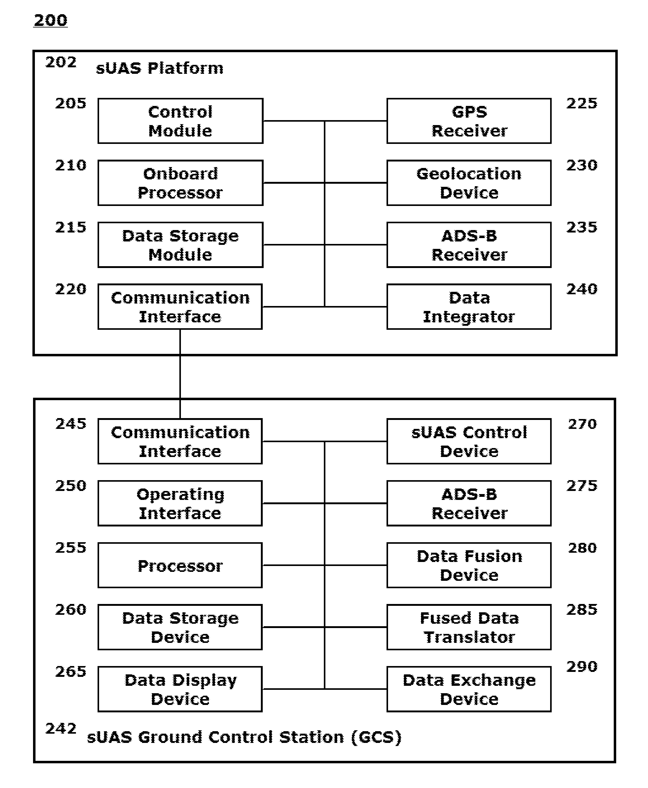
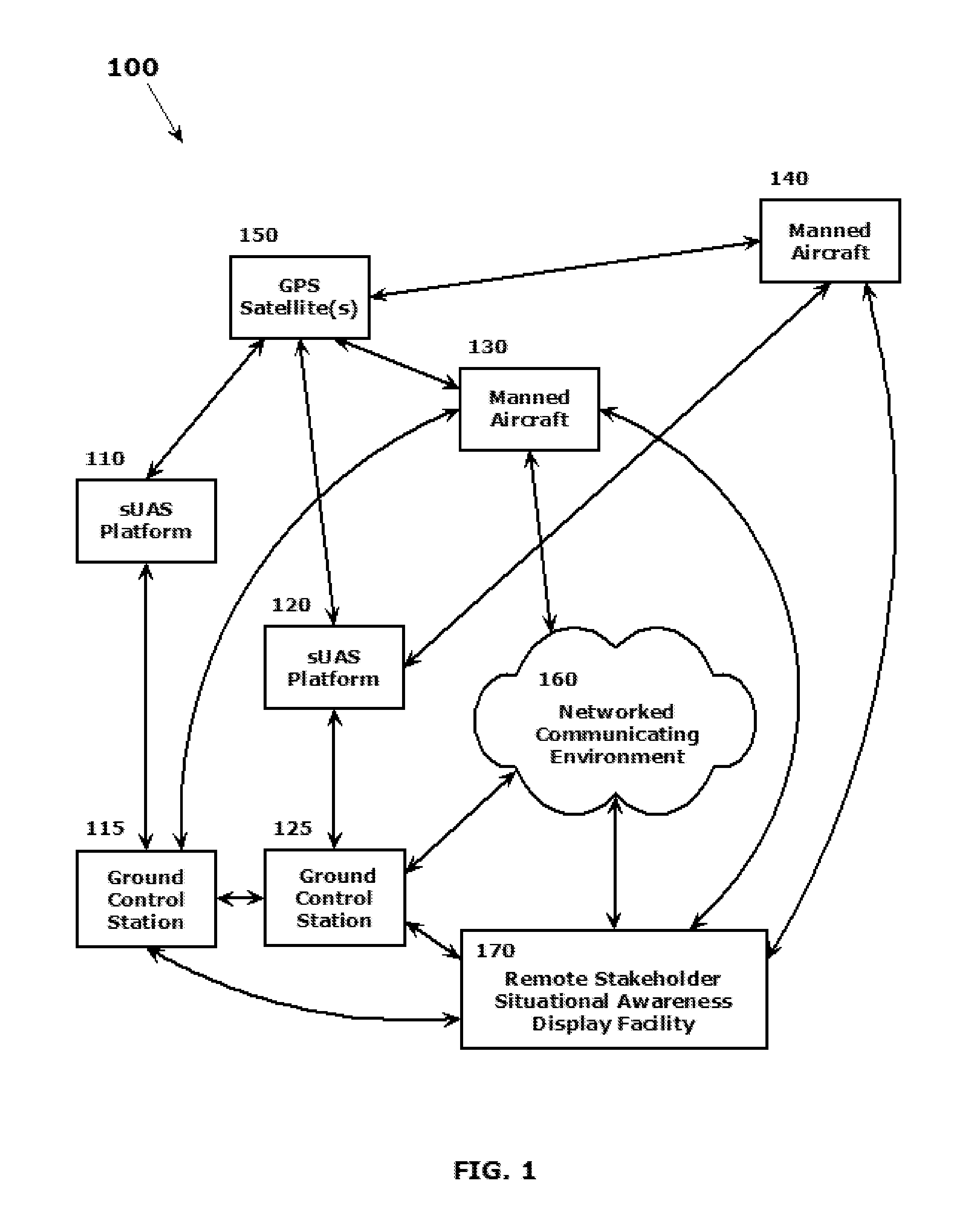
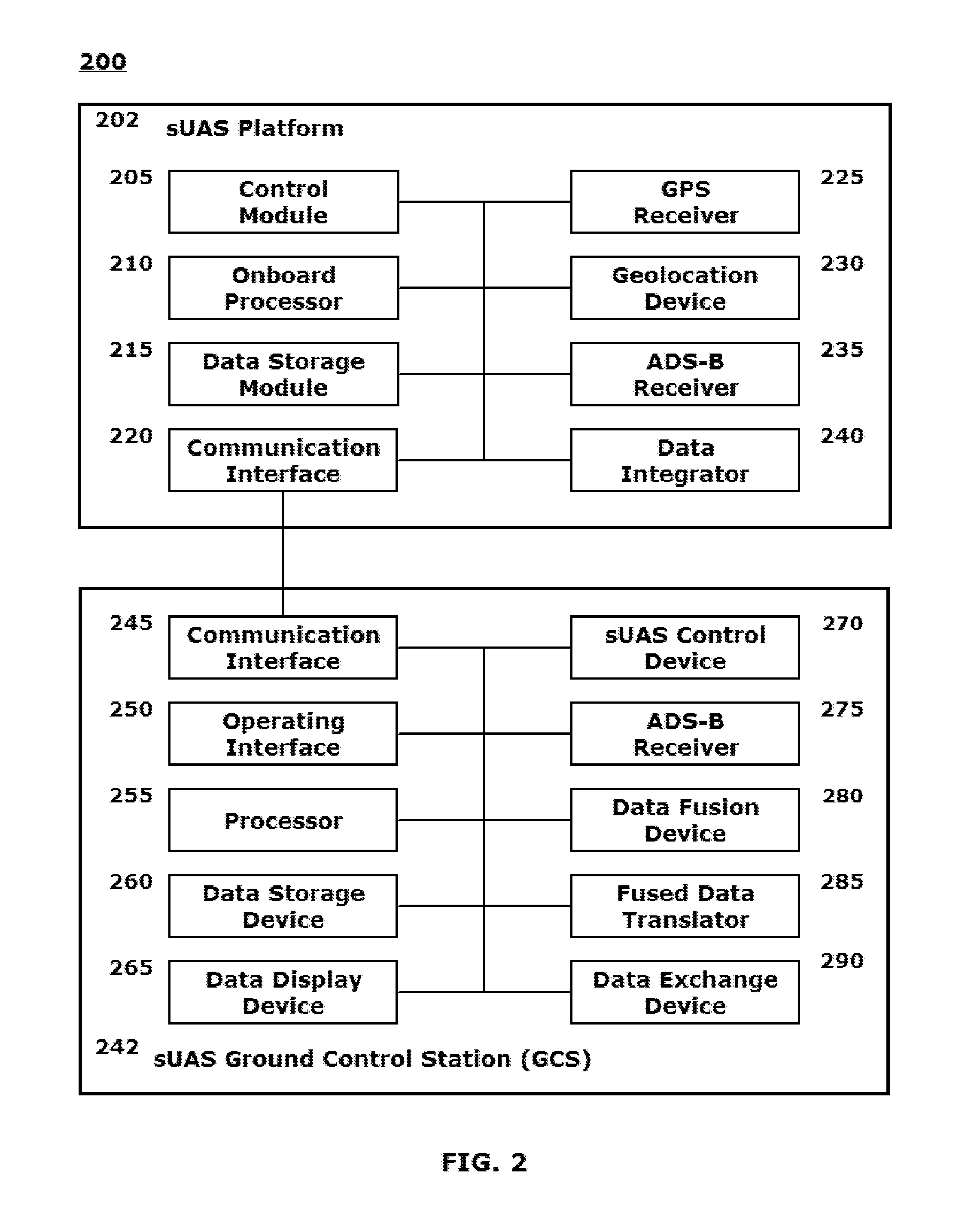
[0002]This disclosure relates to systems and methods for employing local, opportunistic Automatic Dependent Surveillance-Broadcast (ADS-B) information to augment other source “knowledge” of local aircraft position information for improving situational awareness in areas lacking ADS-B coverage provided by other aircraft control agencies.

[0003]2. Related Art

[0004]Deployment scenarios involving unmanned aerial vehicles are increasing as the technology for local and remote control of those vehicles increases, and as government, law enforcement and other entities become aware of, and comfortable with, the capabilities and benefits of routinely employing certain unmanned aerial vehicles for certain mission types. The term “unmanned aerial vehicle(s),” as that term will be used throughout this disclosure, is intended to encompass a particular class of locally, generally line-of-sight, operated flying vehicles, including Unmanned Aerial Vehicles (UAVs) and the related Small Unmanned Aerial ...


PUM


Abstract

A system and method are provided for employing local, opportunistic Automatic Dependent Surveillance-Broadcast (ADS-B) information to augment other source “knowledge” of local aircraft position information for improving situational awareness in areas lacking ADS-B coverage provided by other aircraft control agencies including the Federal Aviation Administration (FAA), other Civil Aviation Authorities (CAAs), and / or other Air Traffic Control (ATC) entities. Locally-received, e.g., in a vicinity of a UAV or sUAS, ADS-B positional information is received by a UAV, sUAS or associated ground control station and integrated on a display component of the ground control station, e.g., a pilot display, for the UAV or sUAS. Received positional information is forwarded to other interested users / systems, including those associated with agencies or entities in overall tactical, operational or surveillance control of a particular area of operations, as appropriate as an integrated situational awareness map display picture.

Description

BACKGROUND[0001]1. Field of the Disclosed Embodiments[0002]This disclosure relates to systems and methods for employing local, opportunistic Automatic Dependent Surveillance-Broadcast (ADS-B) information to augment other source “knowledge” of local aircraft position information for improving situational awareness in areas lacking ADS-B coverage provided by other aircraft control agencies.[0003]2. Related Art[0004]Deployment scenarios involving unmanned aerial vehicles are increasing as the technology for local and remote control of those vehicles increases, and as government, law enforcement and other entities become aware of, and comfortable with, the capabilities and benefits of routinely employing certain unmanned aerial vehicles for certain mission types. The term “unmanned aerial vehicle(s),” as that term will be used throughout this disclosure, is intended to encompass a particular class of locally, generally line-of-sight, operated flying vehicles, including Unmanned Aerial V...

Claims


Application Information

Patent Timeline
Patent Type & Authority Patents(United States)
IPC IPC(8): G05D1/10G05D1/00G06K9/46G08G5/00B64C39/00B64C39/02
CPCG05D1/0022B64C39/024G05D1/0044G08G5/0013G08G5/0026G08G5/0043G08G5/0069G08G5/0082B64U2101/15
Inventor STEFANI, ROLF, R.COOPER, JR., JAMES, GARY
Owner ROCKWELL COLLINS INC
Learn More