
System and method for collecting information related to utility assets

a utility and information technology, applied in the direction of direction finders using radio waves, instruments, reradiation, etc., can solve the problems of loss of life and/or money, further 731 billion dollars in property damage, error of 15 feet or more, etc., to achieve the effect of reducing data accuracy and advantageous damage prevention

Active Publication Date: 2011-12-20
PROSTAR GEOCORP INC
View PDF39 Cites 92 Cited by
  • Summary
  • Abstract
  • Description
  • Claims
  • Application Information

AI Technical Summary

Benefits of technology

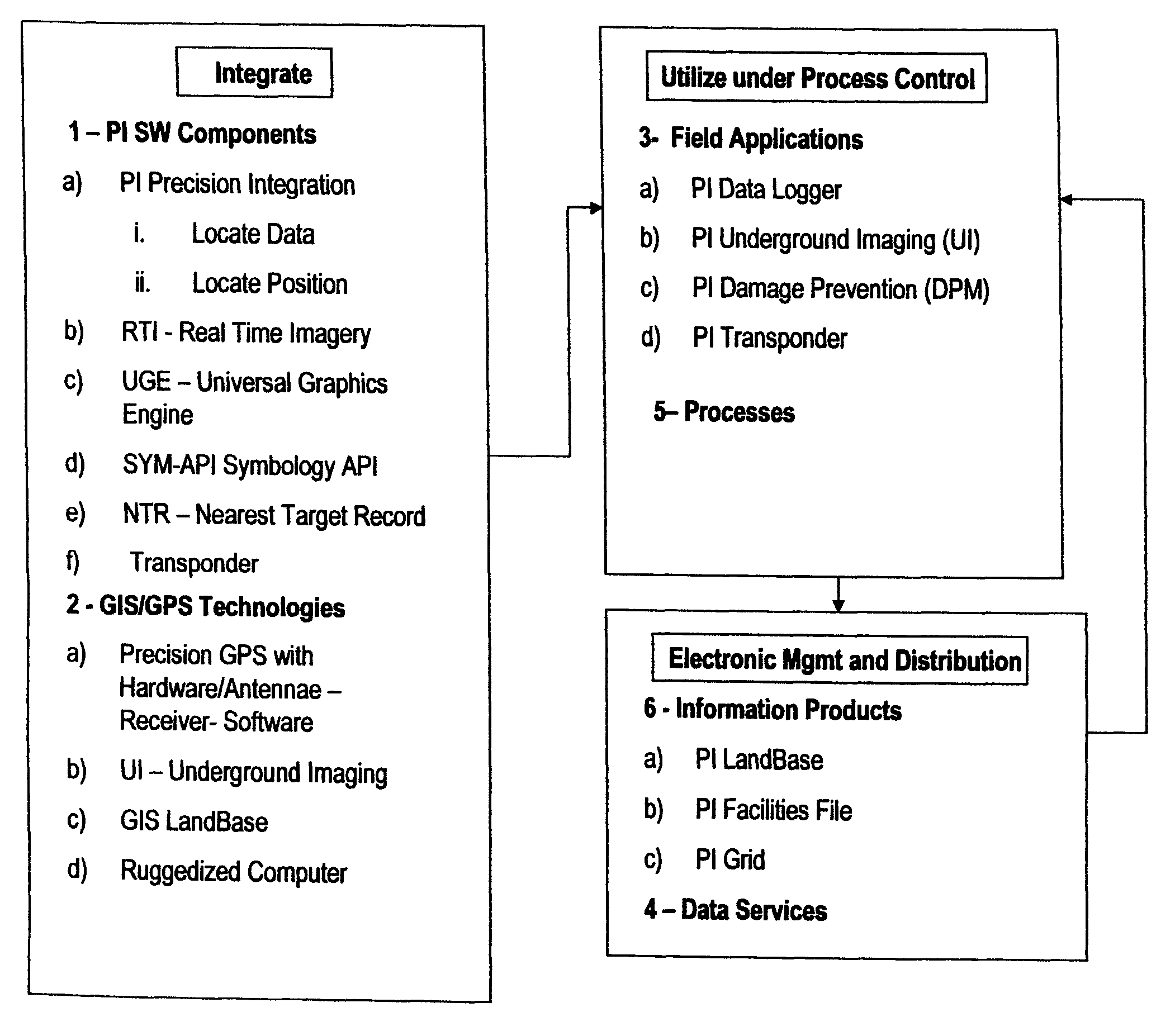
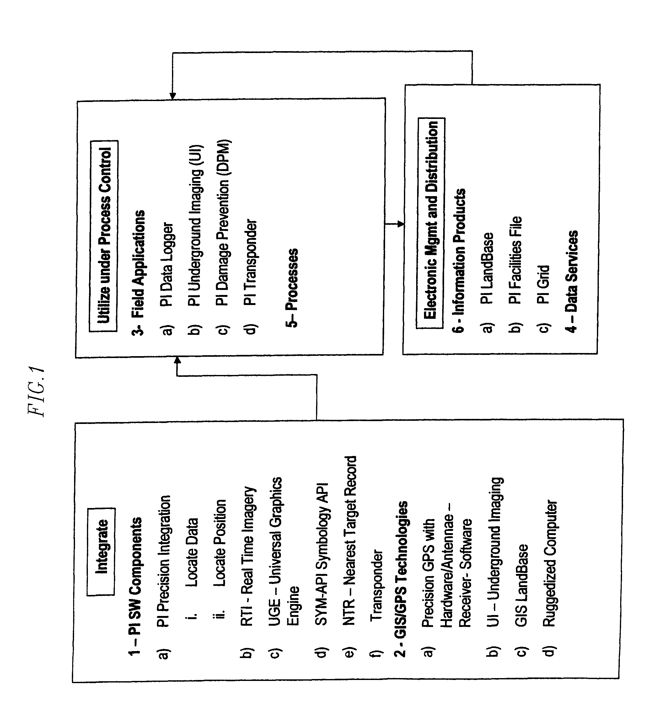
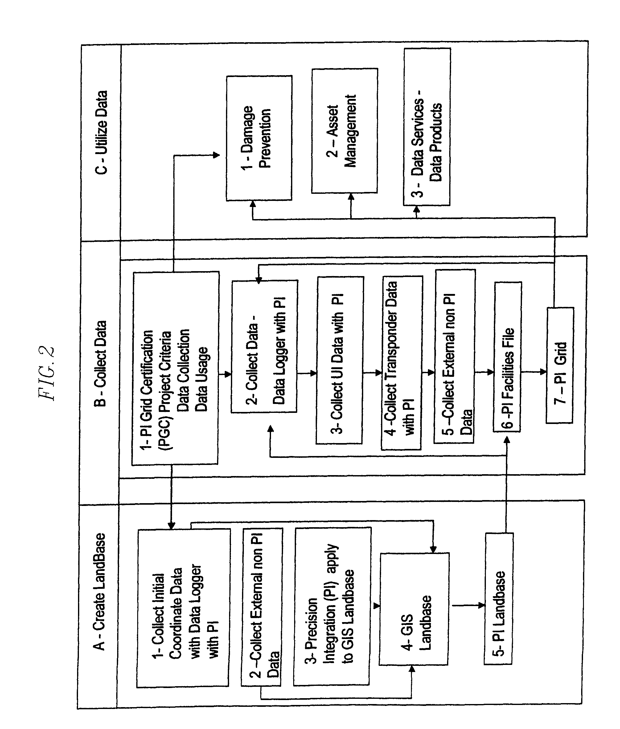
[0012]Some embodiments generate or produce highly accurate information products and applications for field use for Utility Asset Management or Utility Damage Prevention. Some embodiments produce an information product, called a Precision Integration (PI) Grid that is comprised of (above or below ground) utility location data combined with a GIS Landbase that includes satellite and / or other imagery and mapping information. In some embodiments the PI Grid advantageously provides the utility location data accurate to within 10 centimeters, without using real-time kinetics (RTK), and within millimeter accuracy using RTK. Some embodiments also provide for the accurate recall of the information based on the generation of data using precision GPS technologies that provide absolute, as opposed to relative, position data. Here, precision GPS refers to a GPS system that may provide position information with accuracy as set forth herein for PI. Utility location information may be recalled anywhere, anytime in the world with the above mentioned accuracy.
[0030]The use of RTI may be particularly advantageous for damage prevention. The Damage Prevention Module (DPM) may utilize RTI to provide real-time utility location data to operators of ground penetrating equipment to avoid damaging utilities. The DPM may provide sophisticated targeting and ‘lock on’ capabilities that utilize user defined buffers to warn equipment operators of utilities that could be damaged by ground breaking activities.

Problems solved by technology

Every year incidents occur in which mobile ground breaking equipment comes in contact with utility lines with costly results in loss of life and / or loss of money.
There were also 3034 incidents involving utility lines carrying hazardous liquids which killed 36 people, injured 244 people and caused a further 731 billion dollars in property damage.
It has been found that attempting to locate a utility line based op this record has resulted in an error of up to 15 feet or more because of the inaccuracy in the position of the reference point.

Method used


Image

  • System and method for collecting information related to utility assets
  • System and method for collecting information related to utility assets
  • System and method for collecting information related to utility assets

Examples


Embodiment Construction

[0050]The invention is described below, with reference to detailed illustrative embodiments.

[0051]It will be apparent that the invention may be embodied in a wide variety of forms, some of which may be quite different from those of the disclosed embodiments. Consequently, the specific structural and functional details disclosed herein are merely representative and do not limit the scope of the invention. For example, references to specific structures and processes in the disclosed embodiments should be understood to be but one example of structures and processes that may be used in these or other embodiments in accordance with the teachings provided herein. Accordingly, otherwise restrictive nomenclatures such as “is,”“are,” etc. should be understood to include less restrictive meanings such as “may be,” etc. In addition, a reference to an element by an indefinite article such as “a” does not exclude the possibility that more than one of the element is present, unless the context cl...


PUM


Abstract

A method and apparatus, including software, for the development and operational use of precise utility location and utility asset management information. Field-usable data sets may be produced that meet standards of accuracy and usability that are sufficient for use by field operations personnel participating in damage prevention activities associated with ground penetrating projects (e.g., excavating, trenching, boring, driving, and tunneling) or other asset applications. Some embodiments relate to integrating utility asset data including coordinate location, and geographical information data using a consistently available and accurate coordinates reference for collecting the data and for aligning the geographical information data. Some embodiments relate to managing projects with equipment that provides real time images and the updating of the data as required with this desired accuracy.

Description

CROSS-REFERENCE TO RELATED APPLICATION(S)[0001]This application is a continuation of U.S. patent application Ser. No. 12 / 350,141, filed Jan. 7, 2009 now U.S. Pat. No. 7,834,806, which is a divisional of U.S. patent application Ser. No. 11 / 185,579, filed Jul. 19, 2005 now U.S. Pat. No. 7,482,973, which claims the benefit of U.S. Provisional Patent Application No. 60 / 589,307, filed Jul. 20, 2004, the disclosures of which are hereby incorporated by reference herein.TECHNICAL FIELD[0002]This application relates to a system and method for the development and operational use of precise utility location information and utility asset management information.BACKGROUND[0003]There are many assets above ground and below ground that need to be protected and avoided. Included in these assets are utility lines and components and protected areas, such as archeological sites and habitat of endangered species. There are millions of miles of utility lines around the world, some buried and some above g...

Claims


Application Information

Patent Timeline
IPC IPC(8): G01S3/02
CPCG01C15/00G01S13/885
Inventor TUCKER, LAYNE D.LEPPER, JOHNCOLBY, DANIEL E.TUCKER, PAGESAWYER, JR., TOM Y.
Owner PROSTAR GEOCORP INC
Learn More