
GPS access system and method

a gps and access system technology, applied in wave based measurement systems, transmission systems, instruments, etc., can solve the problems of not being able to acquire y codes, not being able to guarantee that they will lock on at all, and subjecting the overall system to additional costs or operational constraints, so as to improve the jam resistance

Active Publication Date: 2006-05-09
THE BOEING CO
View PDF8 Cites 69 Cited by
  • Summary
  • Abstract
  • Description
  • Claims
  • Application Information

AI Technical Summary

Benefits of technology

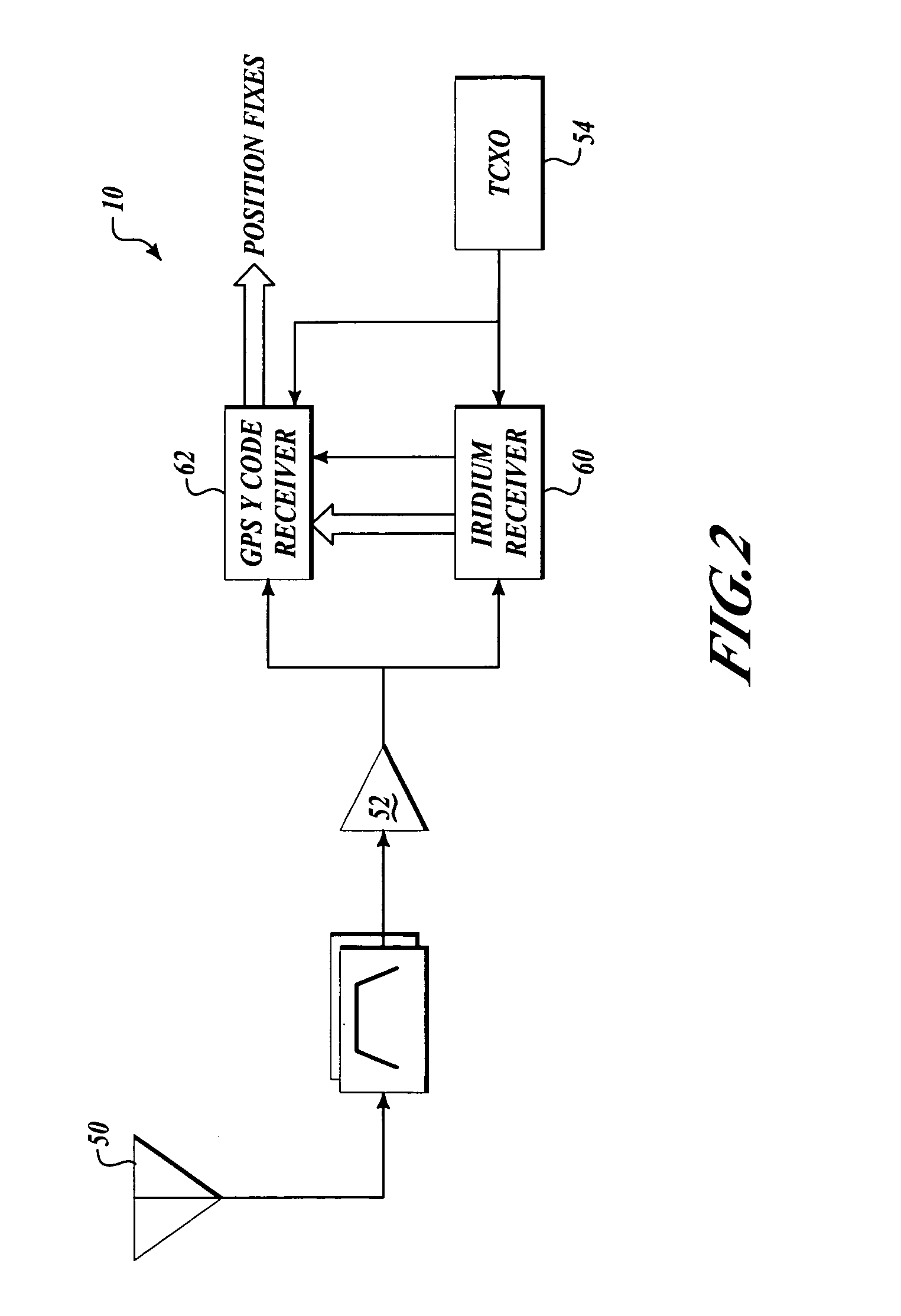
This patent describes a way to get GPS signals even when there are a lot of signals trying to jam them. It does this by adding a signal from a different satellite system, like Iridium, which is broadcasting in a different frequency band. This makes it harder for the jamming signals to interfere with the GPS signals. The invention uses a low-cost integrated receiver that can pick up both GPS and Iridium signals with a single antenna.

Problems solved by technology

In other words, although it may be possible to track the Y code in jammed conditions due to its wider spreading characteristics, under ordinary circumstances it may not be possible to acquire Y code because the C / A code is jammed.
Several previous solutions to the timing initialization problem have been developed and fielded, although they each suffer significant shortfalls that prevent them from realizing the full potential of GPS Y code.
But under stressed conditions, it is not assured that it will lock on at all if its clock is too far off or if its search algorithm just happens to be out of synchronization with the prevailing environmental conditions.
While this may be practical under some circumstances, this method subjects the overall system to additional costs or operational constraints.
Rugged atomic standards generally cost more than the GPS receiver itself.
Such arrangements, while technically feasible, impose unwarranted operational burdens on troops in a hostile environment.
It may be impractical or cumbersome for ground troops or aircraft to take the additional step of physically connecting to an initialization device in an urgent situation or to have to rely on the assumption of ubiquitous ground support infrastructure.
But the '961 patent does not suggest the use of a LEO satellite to assist in acquiring a GPS clock.

Method used


Image

  • GPS access system and method
  • GPS access system and method
  • GPS access system and method

Examples


Embodiment Construction

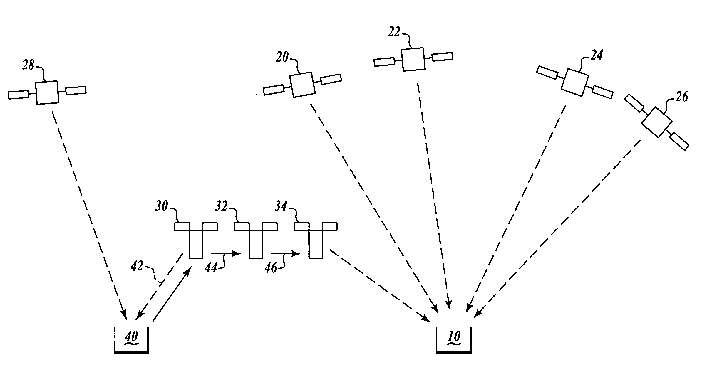
[0023]FIG. 1 shows a block diagram of the preferred embodiment of the system. The user receiver 10 is capable of completely stand alone operation. It contains a military Y-code GPS receiver coupled to an Iridium data receiver. It receives signals from four or more GPS satellites 20–28 and one or more Iridium satellites 20–34 orbiting above. These signals are sufficient to initialize the Y code positioning function of the GPS receiver.

[0024]GPS enables any user to measure GPS time anywhere in the world to within substantially less than one microsecond. At the Iridium gateways 40, ground monitors measure Iridium satellite time by measurements of the Iridium downlink 42. The clocks on each Iridium satellite 30–34 are steered to within ±11 microseconds of the ground reference worst case, although the operational values are typically much better. Therefore, the Iridium ground monitor network can measure the clock offset of each Iridium satellite with respect to GPS time to within a few m...


PUM


Abstract

This invention describes a means for acquiring GPS P / Y code under jamming conditions. It improves jam resistance by augmenting a component of the GPS signal with one from a different satellite system, such as a low earth orbiting (LEO) satellite. The preferred embodiment of this invention employs the Iridium LEO satellite constellation broadcasting in a 10 MHz wide band about 1,621 MHz. A low-cost, integrated Iridium receiver coupled to the GPS receiver employs a single antenna that is capable of receiving both the GPS and Iridium signals together.

Description

[0001]This application claims the benefit of Provisional Patent Application Ser. No. 60 / 475,205 filed on May 30, 2003.FIELD OF THE INVENTION[0002]This invention relates generally to global positioning systems and, more specifically, to systems for accessing GPS signals under jamming conditions.BACKGROUND OF THE INVENTION[0003]GPS, or Global Positioning System, is funded by and controlled by the U.S. Department of Defense (DOD). While there are many thousands of civil users of GPS world-wide, the system was designed for and is operated by the U.S. military. GPS provides specially coded satellite signals that can be processed in a GPS receiver, enabling the receiver to compute position, velocity, and time. Four GPS satellite signals are used to compute positions in three dimensions and the time offset in the receiver clock. The GPS satellites transmit two microwave carrier signals. The L1 frequency (1575.42 MHz) carries the navigation message and the Satellite Positioning Service (SPS...

Claims


Application Information

Patent Timeline
Patent Type & Authority Patents(United States)
IPC IPC(8): H04B7/185G01S5/02G01C21/26G01S1/00G01S5/14G01S19/05G01S19/11G01S19/21G01S19/29G01S19/46
CPCG01S19/215G01S19/425G01S19/32G01S19/235
Inventor WHELAN, DAVID A.GUTT, GREGORY M.FERRELL, BARTON G.COHEN, CLARK
Owner THE BOEING CO
Learn More