
Distributed object-oriented geospatial information distribution system and method thereof

Inactive Publication Date: 2006-01-10
THE UNITED STATES OF AMERICA AS REPRESENTED BY THE SECRETARY OF THE NAVY
View PDF30 Cites 214 Cited by
  • Summary
  • Abstract
  • Description
  • Claims
  • Application Information

AI Technical Summary

Benefits of technology

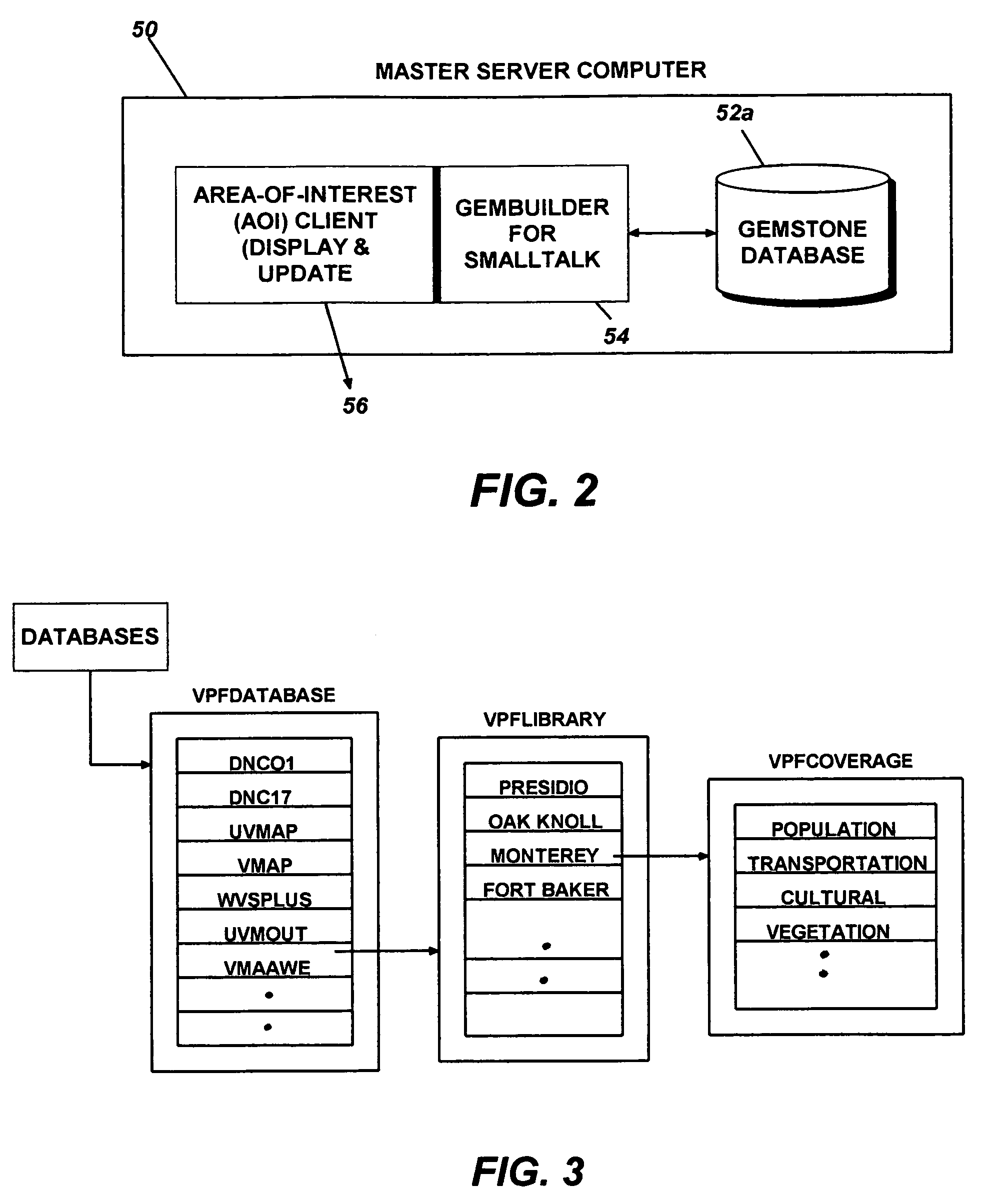
[0016]Further, in a networked computer system environment building and maintaining an object-oriented spatial database from at least two or more data formats by instantiating objects of the object-oriented database, using at least two of the Vector Product Format (VPF), Raster Product Format (RPF), Text Product Standard (TPS), Environmental Systems Research Institute (ESRI) shape, Generic Sensor Format (GSF), Naval Oceanographic Office text (NAVOCEANO), and temporal information databases; initializing spatial and non-spatial feature data of the object-oriented database; and spatially indexing data among objects from the at least two VPF, RPF, TPS, ESRI, GSF, NAVOCEANO and temporal information databases into the single, object-oriented spatial database.
[0017]Further, computer programs according to the present invention and stored on a computer-readable media to acces

Problems solved by technology

Because of the number of tables involved, maintaining referential integrity of the VPF database upon an update is difficult.
This difficulty arises because the VPF relies on data residing within multiple specialized tables on multiple levels of the VPF relational database.
Further, since viewing, query and manipulation of each geospatial data of a different format typically requires corresponding software, integration of the geospatial-data of different formats becomes difficult at best.
This characteristic frustrates easy distribution and access to continuously updated complex data having spatial information and temporal information.
Typically, data distribution in such systems is in the form of CD-ROM or other media, and would often take days to be distributed to user.
Although, efforts have been made to provide retrieval and viewing of mapping data over the World Wide Web (WWW) these applications are limited in the data types that they can display, and in the availability of data associated with the display.

Method used


Image

  • Distributed object-oriented geospatial information distribution system and method thereof
  • Distributed object-oriented geospatial information distribution system and method thereof
  • Distributed object-oriented geospatial information distribution system and method thereof

Examples


Embodiment Construction

[0052]Reference will now be made in detail to the preferred embodiments of the present invention, examples of which are illustrated in the accompanying drawings, wherein like reference numerals refer to like elements throughout. The embodiments are described below to explain the present invention by referring to the figures.

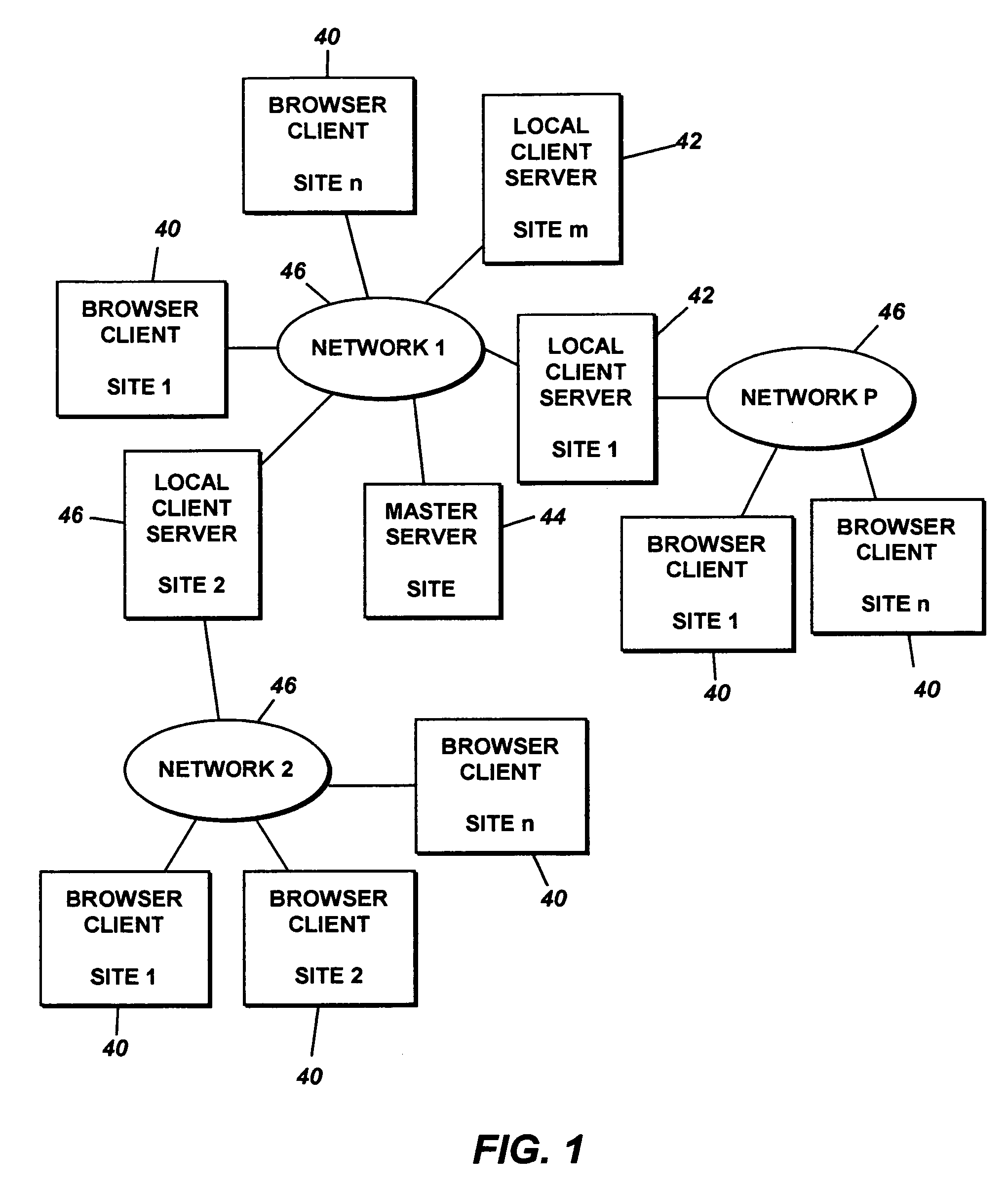
[0053]The database system according to the present invention, uses Internet enabled technology, such as Web browser technology, and object-oriented technology to provide real-time or interactive remote access to geospatial data over a network (i.e., one step). In particular, the user in one step can, for example, view the data objects stored in a remote location (i.e., computer server), without downloading from a remote computer to the local computer the entire database (or an entire segment of the database) on the local computer and executing a separate software in the local computer to view the database. Further, in contrast to traditional GIS software, which a...


PUM


Abstract

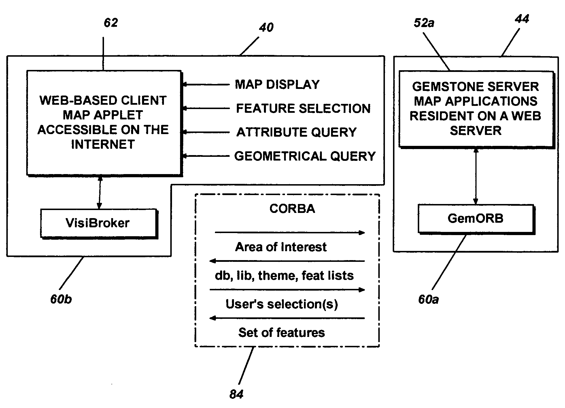
A distributed object-oriented geospatial database system and method thereof over the Internet using Web-based technology to perform data-driven queries, such as retrieving, viewing and updating, geospatial data of the object oriented geospatial database, such as vector, raster, hypertext and multimedia data, including data types or formats of ESRI shape files, GSF, oceanographic ASCII text data by NAVOCEANO and geospatial data with temporal information and supporting 3D display of the geospatial data. The object-oriented geospatial database system is implemented in a heterogeneous object-oriented development and integration environment through the Common Object Request Broker Architecture (CORBA).

Description

RELATED APPLICATION[0001]The present application is related to the commonly assigned pending U.S. patent application Ser. No. 09 / 448,765 filed on Nov. 24, 1999 entitled “Method and Apparatus for Building and Maintaining an Object-Oriented Geospatial Database”, which is incorporated by reference herein. This application claims priority from a provisional application, Ser. No. 60 / 227,847 filed on Aug. 25, 2000, entitled “A DISTRIBUTED OBJECT-ORIENTED GEOSPATIAL INFORMATION DISTRIBUTION SYSTEM AND METHOD THEREOF”, Navy Case No. 80, 172.BACKGROUND OF THE INVENTION[0002]1. Field of the Invention[0003]The present invention relates to distributing information of an object-oriented database using object-oriented technology. More particularly, the present invention relates to distributing and maintaining information of an object-oriented database of geospatial data. Further, the present invention relates to distributing and maintaining information of an object-oriented database of geospatial...

Claims


Application Information

Patent Timeline
IPC IPC(8): G06F15/16
CPCG06F17/3087G06F17/30241G06F16/29G06F16/9537
Inventor WILSON, RUTHCHUNG, MIYICOBB, MARIASHAW, KEVINLADNER, ROY
Owner THE UNITED STATES OF AMERICA AS REPRESENTED BY THE SECRETARY OF THE NAVY
Learn More