Automated map making and positioning

a map making and positioning technology, applied in the field of image processing, can solve the problems of inaccurate mapping and positioning, inability to perform very well in real-world applications, and difficulty in conventional solutions for creating maps,

Pending Publication Date: 2022-07-07
ZENUITY AB
View PDF0 Cites 0 Cited by
  • Summary
  • Abstract
  • Description
  • Claims
  • Application Information

AI Technical Summary

Benefits of technology

[0008]It is therefore an object to provide a method for automated map generation, a non-transitory computer-readable storage medium, a vehicle control device and a vehicle comprising such a control device, which alleviate all or at least some of the drawbacks of presently known solutions.
[0009]It is another object to provide a method for automated positioning of a vehicle on a map, a non-transitory computer-readable storage medium, a vehicle control device and a vehicle comprising such a control device, which alleviate all or at least some of the drawbacks of presently known solutions.
[0012]The method provides for a reliable and effective solution for generating maps online in a vehicle based on the vehicle's sensory perception of the surrounding environment. Thus alleviating the need for manually creating, storing and / or transmitting large amounts of map data. In more detail, the presented method utilizes the inherent advantages of trained self-learning models (e.g. trained artificial networks) to efficiently collect and sort sensor data in order to generate high definition (HD) maps of a vehicle's surrounding environment “on-the-go”. Various other AD or ADAS features can subsequently use the generated map.
[0018]Yet further, in accordance with yet another exemplary embodiment of the present disclosure, the method further comprises processing the received sensor data with the received geographical position in order to form a temporary perception of the surrounding environment, comparing the generated map with the temporary perception of the surrounding environment in order to form at least one parameter. Further, the method comprises comparing the first parameter with at least one predefined threshold, and sending a signal in order to update at least one weight of at least one of the first self-learning model and the map generating self-learning model based on the comparison between the at least one parameter and the at least one predefined threshold. In other words, the method may further include scalable and efficient process for evaluating and updating the map, or more specifically, for evaluating and updating the self-learning models used to generate the map in order to ensure that the map is as accurate and up-to-date as possible.
[0022]Further, according to a fifth aspect of the present disclosure there is provided a method for automated map positioning of a vehicle on a map. The method comprises receiving sensor data from a perception system of a vehicle. The perception system comprises at least one sensor type, and the sensor data comprises information about a surrounding environment of the vehicle. The method further comprises online extracting, using a first trained self-learning model, a first plurality of features of the surrounding environment based on the received sensor data. Moreover, the method comprises receiving map data including a map representation of the surrounding environment of the vehicle, and online fusing, using a trained positioning self-learning model, the first plurality of features in order to form a second plurality of features. Next, the method comprises online determining, using the trained positioning self-learning model, a geographical position of the vehicle based on the received map data and the second plurality of features. Hereby presenting a method capable of precise and consistent positioning of a vehicle on the map by efficient utilization of trained self-learning models (e.g. artificial neural networks).
[0028]Yet further, in accordance with yet another exemplary embodiment of the present disclosure, the method further comprises receiving a set of reference geographical coordinates from a localization system of the vehicle, and comparing the determined geographical position with the received set of reference geographical coordinates in order to form at least one parameter. Further, the method comprises comparing the at least one parameter with at least one predefined threshold, and sending a signal in order to update at least one weight of at least one of the first self-learning model and the trained positioning self-learning model based on the comparison between the at least one parameter and the at least one predefined threshold. In other words, the method may further include scalable and efficient process for evaluating and updating the map positioning solution, or more specifically, for evaluating and updating the self-learning models used to position the vehicle in the map in order to ensure that the map positioning solution is as accurate and up-to-date as possible.

Problems solved by technology

But SLAM methods do not perform very well in the real-world applications.
The limitations and the noise in the sensor inputs propagate from the mapping phase to the positioning phase and vice versa, resulting in inaccurate mapping and positioning.
However, despite their good performance, the conventional solutions for creating maps have some major challenges and difficulties.
For example, the process of creating maps is very time consuming and not fully automated, and the solutions are not fully scalable, so they do not work everywhere.
Moreover, conventional methods usually consume a lot of memory to store high-resolution maps, and they have some difficulties in handling sensor noise and occlusion.
Further, finding changes in the created maps and updating them is still an open question and it is not an easy problem for these methods to solve.

Method used


Image

  • Automated map making and positioning
  • Automated map making and positioning
  • Automated map making and positioning

Examples


Embodiment Construction

[0042]Those skilled in the art will appreciate that the steps, services and functions explained herein may be implemented using individual hardware circuitry, using software functioning in conjunction with a programmed microprocessor or general purpose computer, using one or more Application Specific Integrated Circuits (ASICs) and / or using one or more Digital Signal Processors (DSPs). It will also be appreciated that when the present disclosure is described in terms of a method, it may also be embodied in one or more processors and one or more memories coupled to the one or more processors, wherein the one or more memories store one or more programs that perform the steps, services and functions disclosed herein when executed by the one or more processors.

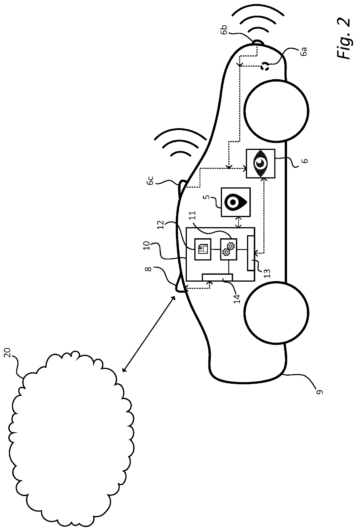
[0043]FIG. 1 illustrates a schematic flow chart representation of a method 100 for automated map generation in accordance with an embodiment of the present disclosure. The method 100 comprises receiving 101 sensor data from a perc...


PUM


Abstract

An automated map generation and map positioning solution for vehicles is disclosed. The solution includes a method for map generation based on the vehicle's sensory perception of the surrounding environment. Moreover, presented map generating method utilizes the inherent advantages of trained self-learning models (e.g. trained artificial networks) to efficiently collect and sort sensor data in order to generate high definition (HD) maps of a vehicle's surrounding environment “on-the-go”. In more detail, the automated map generation method utilizes two self-learning models are used, one general, low-level, feature extraction part and one high-level feature fusion part. The automated positioning method is based on similar principles as the automated map generation, where two self-learning models are used, one “general” feature extraction part and one “task specific” feature fusion part for positioning in the map.

Description

TECHNICAL FIELD[0001]The present disclosure generally relates to the field of image processing, and in particular to a method and device for generating high resolution maps and positioning a vehicle in the maps based on sensor data by means of self-learning models.BACKGROUND[0002]During these last few years, the development of autonomous vehicles has exploded and many different solutions are being explored. Today, development is ongoing in both autonomous driving (AD) and advanced driver-assistance systems (ADAS), i.e. semi-autonomous driving, within a number of different technical areas within these fields. One such area is how to position the vehicle consistently and precisely since this is an important safety aspect when the vehicle is moving within traffic.[0003]Thus, maps have become an essential component of autonomous vehicles. The question is not anymore if they are useful or not, but rather how maps should be created and maintained in an efficient and scalable way. In the f...

Claims


Application Information

Patent Timeline
Patent Type & Authority Applications(United States)
IPC IPC(8): G01C21/00G06K9/62
CPCG01C21/3848G01C21/3819G06K9/629G01C21/32G06N3/08G06N3/044G06N3/045G06F18/253
Inventor BAGHERI, TOKTAMALIBEIGI, MINA
Owner ZENUITY AB
Why Eureka
Try Eureka