
Program-Storing Computer-Readable Storage Medium, Computer Program Product, Navigation Device and Control Method Thereof

a computer program and program-storing technology, applied in surveying, navigation, navigation instruments, etc., can solve the problems of unpredictable safety problems, limit the driver to a certain driving speed, and the prior art navigation system cannot remind the driver, so as to ensure the safety of the user and reduce the driving speed

Inactive Publication Date: 2012-12-20
MITAC INT CORP +1
View PDF7 Cites 4 Cited by
  • Summary
  • Abstract
  • Description
  • Claims
  • Application Information

AI Technical Summary

Benefits of technology

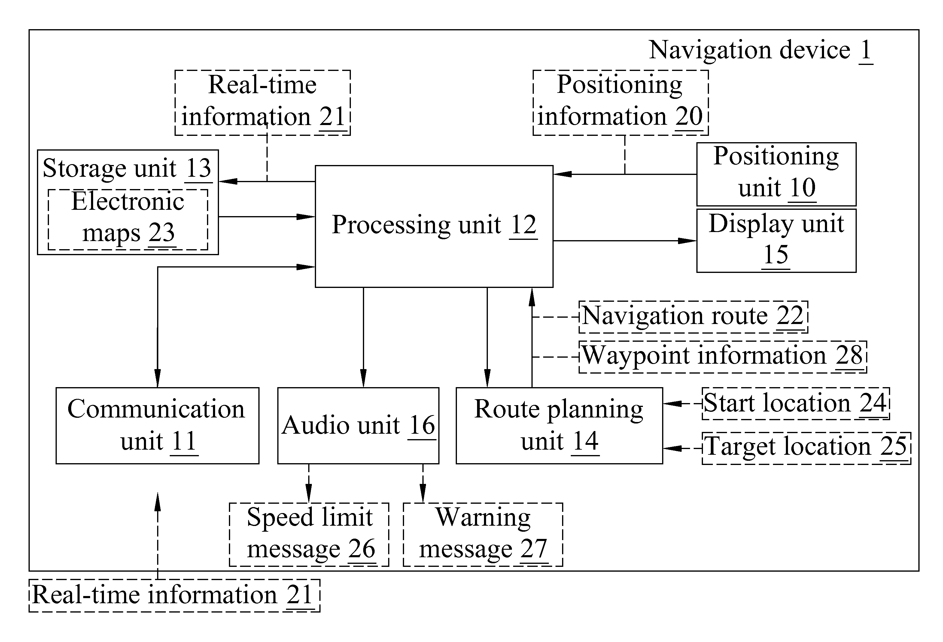
[0003]A primary object of the present invention is to provide a program-storing computer-readable storage medium, a computer program product, a navigation device and a control method thereof, so as to solve the safety problems that would otherwise occur when the navigation device user has no idea about real-time road condition when being guided by the navigation device under different objective conditions, such as weather, traffic flow, road condition and the like.
[0017]To achieve the above and other objects, the program-storing computer-readable storage medium according to the present invention allows a computer to load and execute the program stored therein to thereby implement the above-described navigation device control method.
[0019](1) The navigation device and the control method thereof are able to provide a speed limit message to the user if it is determined based on different objective conditions that a distance between the vehicle carrying the navigation device and a waypoint is within a preset distance range, so as to remind the user to reduce his or her driving speed; and

Problems solved by technology

However, the above-described navigation system still has some problems in practical operation thereof and accordingly, requires improvements.
For example, when driving in different objective environmental conditions, such as driving in a heavy rainy day, driving on a flooded road or a snow-deposited road, or passing road works or a road accident, the prior art navigation system would not be able to remind the driver of such conditions in advance and limit the driver to a certain a driving speed.
Without such services, the driver might drive at a relative high speed to cause unpredictable safety problems.
That is, the conventional navigation system can only guide the user to a desired destination without the function of ensuring the user's safety in driving.

Method used


Image

  • Program-Storing Computer-Readable Storage Medium, Computer Program Product, Navigation Device and Control Method Thereof
  • Program-Storing Computer-Readable Storage Medium, Computer Program Product, Navigation Device and Control Method Thereof
  • Program-Storing Computer-Readable Storage Medium, Computer Program Product, Navigation Device and Control Method Thereof

Examples


first embodiment

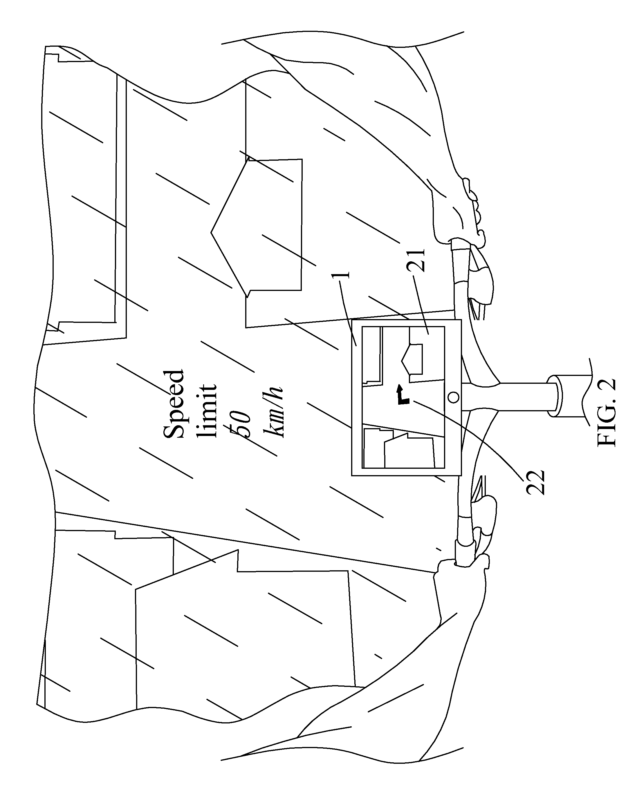
[0034]Please refer to FIG. 2 along with FIG. 1. FIG. 2 schematically shows the navigation device of the present invention. As shown, the navigation device 1 is used in a rainy day. The processing unit 12 of the navigation device 1 will then generate a safety speed range, such as 20 km / h to 30 km / h, according to the received real-time information 21, such as information about rainfall and / or road condition. The processing unit 12 further uses the navigation route 22 and the positioning information 20 as a basis to determine whether a distance between the vehicle carrying the navigation device 1, such as a bicycle, and a waypoint, such as a landmark, a roundabout, a cross road or a curve road, is smaller than a preset distance range, such as 100 meters. When the vehicle carrying the navigation device 1 moves into the preset distance range, the processing unit 12 will provide a speed limit message 26 based on the safety speed range and control the display unit 15 to display the image d...

second embodiment

[0036]Please refer to FIGS. 3A and 3B, which show the navigation device 1 of the present invention, respectively with a speed limit message 26 and a warning message 27 shown thereon. In FIG. 3A, when a distance between the vehicle carrying the navigation device 1, such as a car, and a waypoint, such as a cross road or a curve road, is smaller than a preset distance range, such as 200 meters, the processing unit 12 will then provide a speed limit message 26 based on the safety speed range, such as 30 km / h, and control the display unit 15 to display the image data of the speed limit message 26 and / or control the audio unit 16 to output the audio data of the speed limit message 26.

[0037]In FIG. 3B, when the distance between the vehicle carrying the navigation device 1 and the waypoint is smaller than the preset distance range, the processing unit 12 further determines whether the current speed of the vehicle with the navigation device 1 is higher than the safety speed range, such as 30...


PUM


Abstract

A navigation device includes a processing unit electrically connected to a positioning unit and a communication unit. The positioning unit determines a current location of the navigation device and provides corresponding positioning information. The communication unit receives real-time information. The processing unit uses the real-time information and information about a waypoint as a basis to generate a safety speed range, and uses a navigation route and the positioning information as a basis to determine whether a distance between the navigation device and the waypoint is smaller than a preset distance range. If yes, the processing unit provides a speed limit message based on the safety speed range. A navigation device control method as well as a program-storing computer-readable storage medium and a computer program product enabling implementation of the control method are also disclosed.

Description

FIELD OF THE INVENTION[0001]The present invention relates to a program-storing computer-readable storage medium, a computer program product, a navigation device and a control method thereof; and more particularly, to a navigation device and control method thereof that is able to receive different real-time information about, for example, weather, traffic flow and / or road condition, and correspondingly provide speed limit message or warning message in advance.BACKGROUND OF THE INVENTION[0002]Currently, a prior art navigation system provides car navigation service by receiving Global Positioning System (GPS) real-time signals to determine the device's current location and using navigation software with map information. According to the most common way of navigation provided by the conventional navigation system, the car's current location is defined as a start location, and a user inputs a target location to the navigation device, so that the navigation system computes to find the sho...

Claims


Application Information

Patent Timeline
Patent Type & Authority Applications(United States)
IPC IPC(8): G01C21/34G01C21/36
CPCG01C21/3697G08G1/096716G08G1/09675G08G1/096775
Inventor ZHANG, YIN-HE
Owner MITAC INT CORP
Learn More