
LED light global positioning and routing communication system

Active Publication Date: 2008-11-27
FEDERAL LAW ENFORCEMENT DEV SERVICES
View PDF99 Cites 105 Cited by
  • Summary
  • Abstract
  • Description
  • Claims
  • Application Information

AI Technical Summary

Benefits of technology

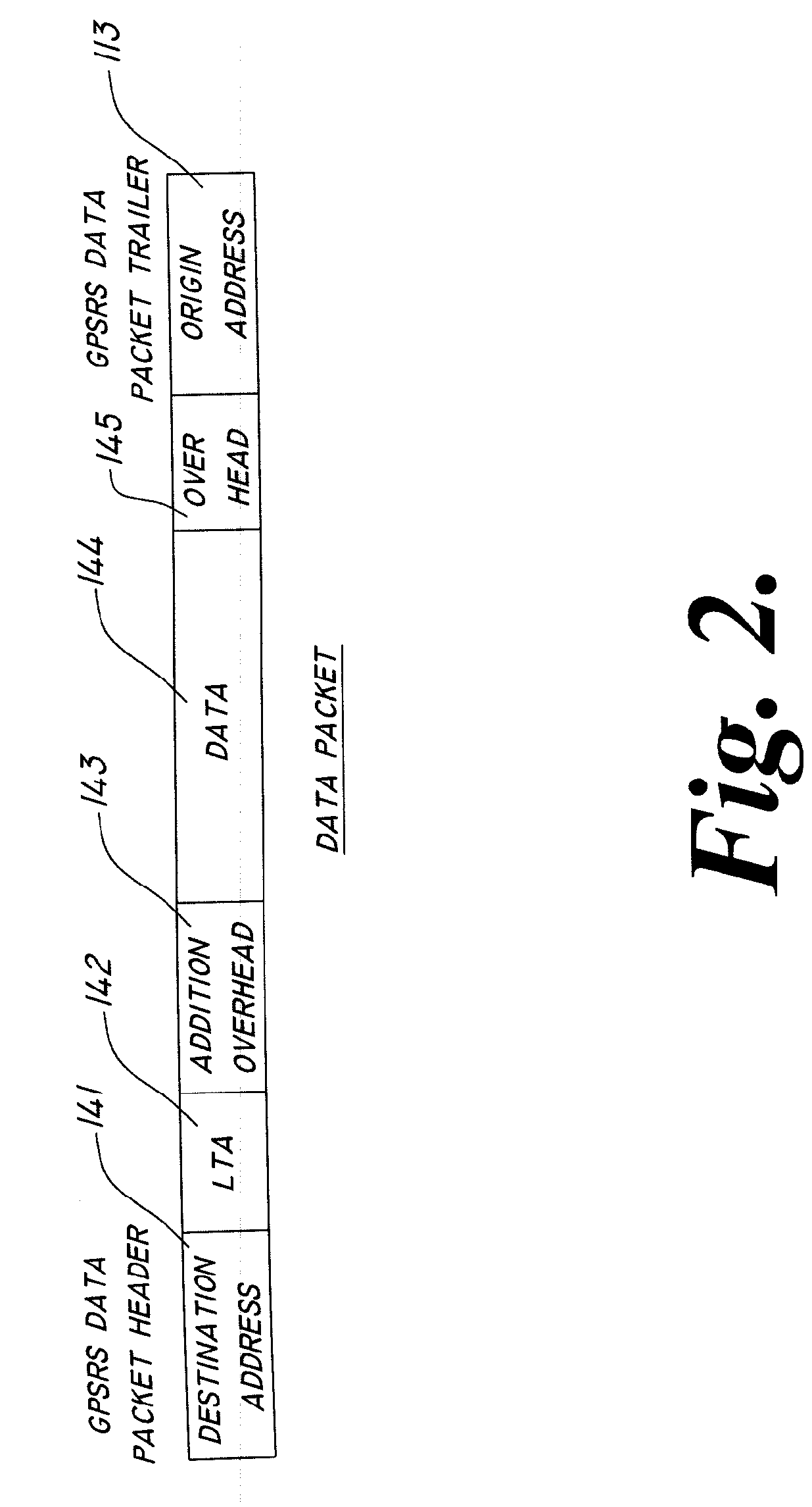
[0010]The present invention creates a much more reliable and accurate comparison for global positioning system (GPS) or instrument flight rules (IFR), and similar systems and services. Additionally, the present invention verifys data in real time through such a comparison. The present invention also incorporates improved real-time tracking of addresses which can be stationary or dynamic in their physical location, especially and is useful for identification of location based services that require the exact location of a vehicle or individual such as emergency vehicle repair services. The present invention ties data packets to geographic locations on a real-time basis rather than using cyber translations. As a corollary thereto, the present invention in real-time recognizes packeted information and the location of a vehicle or individual using accommodating technology. The present invention also includes the ability to use “mesh-networking,” reducing data packet traffic on the “Network Backbone.” The present invention incorporates the use real time locating systems for humans, permitting electronic monitoring and locating in or after emergency situations, or for simple real-time locators. Similarly, inanimate objects such as vehicles may be tracked through the network and accounted for automatically, using less sophisticated communications tags. Additionally, the present invention has the ability for unauthorized infrastructure detection, using an address system identifying the location of the device (GPS), a unique serial number, and a governing infrastructure list which may “lock out” devices not on the governing list. On an open road that is particularly useful because all can drive on the road but only those with authorization may access any data packets and only those with higher levels of clearance may alter the information. The present invention additionally includes sufficient communication bandwidth to incorporate smart video integration. Furthermore, the present invention has the ability to track an origin address upon receiving it, verifying the source in real time.

Problems solved by technology

The cell phone system poses several well-known issues, the first of which is coverage.
Presently, there are not enough towers to provide coverage in all areas, creating a likelihood of dropped calls in certain geographic areas.
The possibility of dropped calls or dropped signal is a distinct disadvantage, and, in fact, could pose a hazard in the case of an emergency situation.
Radio frequency interference and weak signals also raise the issue of one receiving false information, such as in the case of alternative information being transmitted or key information being left out or dropped in the case of weak or variable transmissions.
Additionally, cell phone communications systems are quite limited in bandwidth or capacity for high-speed data communications.
Not only are satellite systems expensive and subject to atmospheric interference, they have other limitations as well.
One such limitation is accuracy.
GPS is accurate to within a couple hundred feet horizontally, but many drivers using GPS systems still find themselves frustrated when the GPS provides them with inaccurate directions, either causing them to arrive at the wrong destination, or being told to make a U-turn after following directions because the GPS is not accurate enough to correctly read the street that vehicle is on.
Furthermore, current GPS devices do not have the capacity to store enough information to provide drivers with more than a crude map, making the identification of where one is unnecessarily difficult.
Systems have been developed that conceptually provide photographic or even three-dimensional mapping and guidance, but storage of such data drastically exceeds portable GPS equipment capacity.
Finally, satellites are not always accessible when there is not a line of communication with the satellite.
For exemplary purposes, car-ports, overhangs, underpasses, garages, buildings and many other shelters and covers can interfere with or completely inhibit satellite reception.
These communications can be skewed or blocked undesirably.
This technique suffers from similar limitations of accuracy and coverage as the satellite system.
Whether using GPS systems or cell phones, triangulation techniques are typically only accurate within several hundred feet.

Method used


Image

  • LED light global positioning and routing communication system
  • LED light global positioning and routing communication system
  • LED light global positioning and routing communication system

Examples


Embodiment Construction

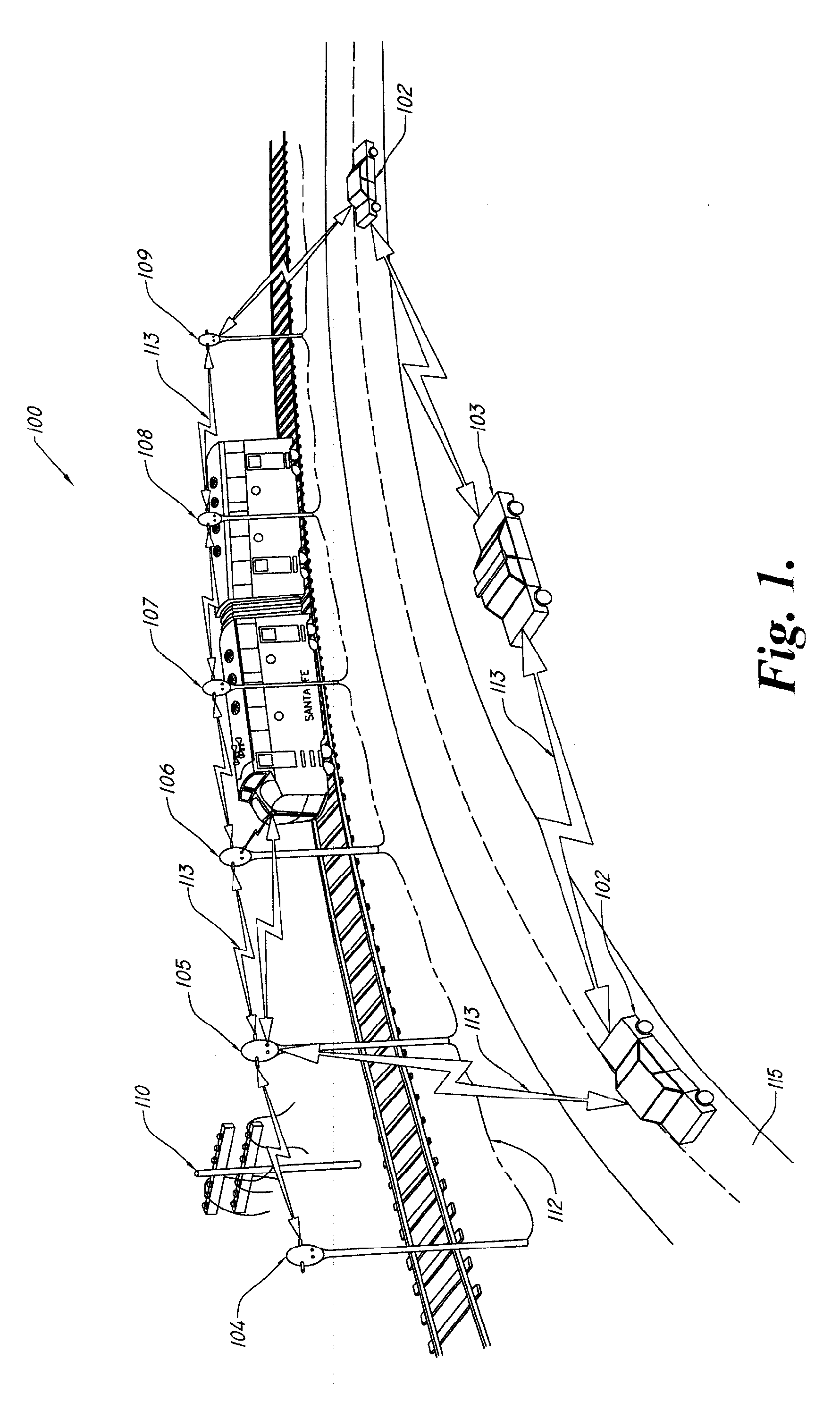
[0017]Manifested in the preferred embodiment GPSRS 100, the present invention provides visible light in combination with embedded communications. The embedded communications in accord with an embodiment of the invention further incorporate GPS routing information into communications networks. In accord with the present invention, there are two types of lights: static or stationary lights, such as a street lamps 104-109, or dynamic moving lights such as automobile lights found in vehicles 102 and patrol car 103. Stationary lights such as street lamps 104-109 are fitted with LED illumination and integral data communications, referred to herein as Visible Light Embedded Communications (VLEC). The physical location of each stationary light, in the form of GPS coordinates, is stored within that light in electronic form, preferably using Read-Only Memory (ROM) or the like, such that the address may not later be altered or tampered with. An address is a GPS location of the stationary light...


PUM


Abstract

An LED light and communication system includes at least one optical transceiver, the optical transceiver including a light support and a processor. The light support has a plurality of light emitting diodes and at least one photodetector attached thereto. The processor is in communication with the light emitting diodes and the at least one photodetector, where the processor is constructed and arranged to illuminate at least one of the light emitting diodes to generate a light signal which in turn includes at least one embedded data packet. The at least one embedded data packet communicates global positioning system (GPS) location information.

Description

CROSS REFERENCE TO RELATED APPLICATIONS[0001]This application claims priority to U.S. provisional patent application Ser. No. 60 / 931,611 filed May 24, 2007, the disclosure which is expressly incorporated herein by reference.STATEMENT AS TO RIGHTS TO INVENTIONS MADE UNDER FEDERALLY SPONSORED RESEARCH AND DEVELOPMENT[0002]Not applicable.FIELD OF THE INVENTION[0003]This invention pertains generally to multiplex communications, and more particularly to versatile communications incorporating GPS locations into data packet headers and trailers. The data packet headers may then be transmitted based upon physical location, and various comparisons may be made between predetermined physical locations and electronic markers and position indicators used for many diverse, critical purposes. In more specific embodiments, Visual Light Embedded Communications (VLEC) are combined with GPS headers to provide many unexpected and novel benefits.DESCRIPTION OF THE RELATED ART[0004]Communication and data...

Claims


Application Information

Patent Timeline
IPC IPC(8): H04B10/00G01S1/00G01S19/48H05B44/00
CPCH04B10/1143H04B10/1149H04B10/40H04B10/116H05B37/0272H04B10/00H04K1/10H04K3/22H04K3/90H04K2203/22H04B3/54H04W4/025H05B47/195H05B45/20H05B47/115G01S2201/01G01S1/7038G01S1/7034Y02B20/40H04B10/11H04B10/1141H04B10/114H05B47/185H04B10/502H04Q11/0003
Inventor PEDERSON, JOHN C.
Owner FEDERAL LAW ENFORCEMENT DEV SERVICES
Learn More