
Itinerary planning system and method

a planning system and itinerary technology, applied in the field of data processing technologies, can solve the problems of inconvenient driving, inability to look at a map at the same time for obvious safety, and way too slow data,

Inactive Publication Date: 2007-06-28
MITAC INT CORP
View PDF3 Cites 64 Cited by
  • Summary
  • Abstract
  • Description
  • Claims
  • Application Information

AI Technical Summary

Benefits of technology

[0006]In light of the drawbacks in the prior arts, a primary objective of the present invention is to provide an itinerary planning system and method that is capable of planning at least one valid itinerary based on the given itinerary planning conditions in addition to the desired destination.
[0013]Compared to the prior art, the itinerary planning system and method proposed by the present invention is capable of presenting multiple itineraries according to the preset itinerary planning conditions rather than simply relying on a chosen location / destination, thereby realizing the goal of providing diversified as well as optimal traveling itineraries for further consideration and selection.

Problems solved by technology

This mode of planning has several disadvantageous, for example, the update of such printed map versions is way too slow to provide the latest travel information, and, in addition, it is impossible to look at a map and drive at the same time for obvious safety reasons.
Therefore, it is quite inconvenient for people who do not have a good sense of direction or drivers who are unfamiliar with certain geographical locations.
Additionally, paper maps cannot provide real-time information on weather or traffic conditions.
While such satellite navigation devices integrated with satellite navigation hardware / software and electronic mapping software can overcome the disadvantageous of using printed maps for travel guidance, navigation information can only be generated in a passive manner solely based on the conditions provided by the user.
Specifically, such systems generally only allow the user to input one starting point and one end point to enable a conventional satellite navigation device to do real-time navigation of planning routes based on reasonable assumptions (such as the desirability for the shortest distance, the least congested routes, or routes without accidents and so on).
Therefore, the conventional satellite navigation device can only make travel itinerary plans in a passive way instead of an integrated and convenient manner according to the location / destination information input by the user.
If the user is unfamiliar with a particular destination region, then the user may not choose the most interesting activities available, thus preventing the user from taking full advantage of the experiences available at the chosen travel destination.
In addition, for users who do not have specific locations / destinations in mind or are not familiar with route information, it is difficult for them to provide the satellite navigation system with sufficient information so that the system can plan an ideal itinerary accordingly.
Thus, the conventional satellite navigation system lacks flexibility and doesn't provide diversity in generating itineraries.

Method used


Image

  • Itinerary planning system and method
  • Itinerary planning system and method
  • Itinerary planning system and method

Examples


Embodiment Construction

[0017]The present invention is described in the following so that one skilled in the pertinent art can easily understand other advantages and effects of the present invention. The present invention may also be implemented and applied according to other embodiments, and the details may be modified based on different views and applications without departing from the spirit of the invention.

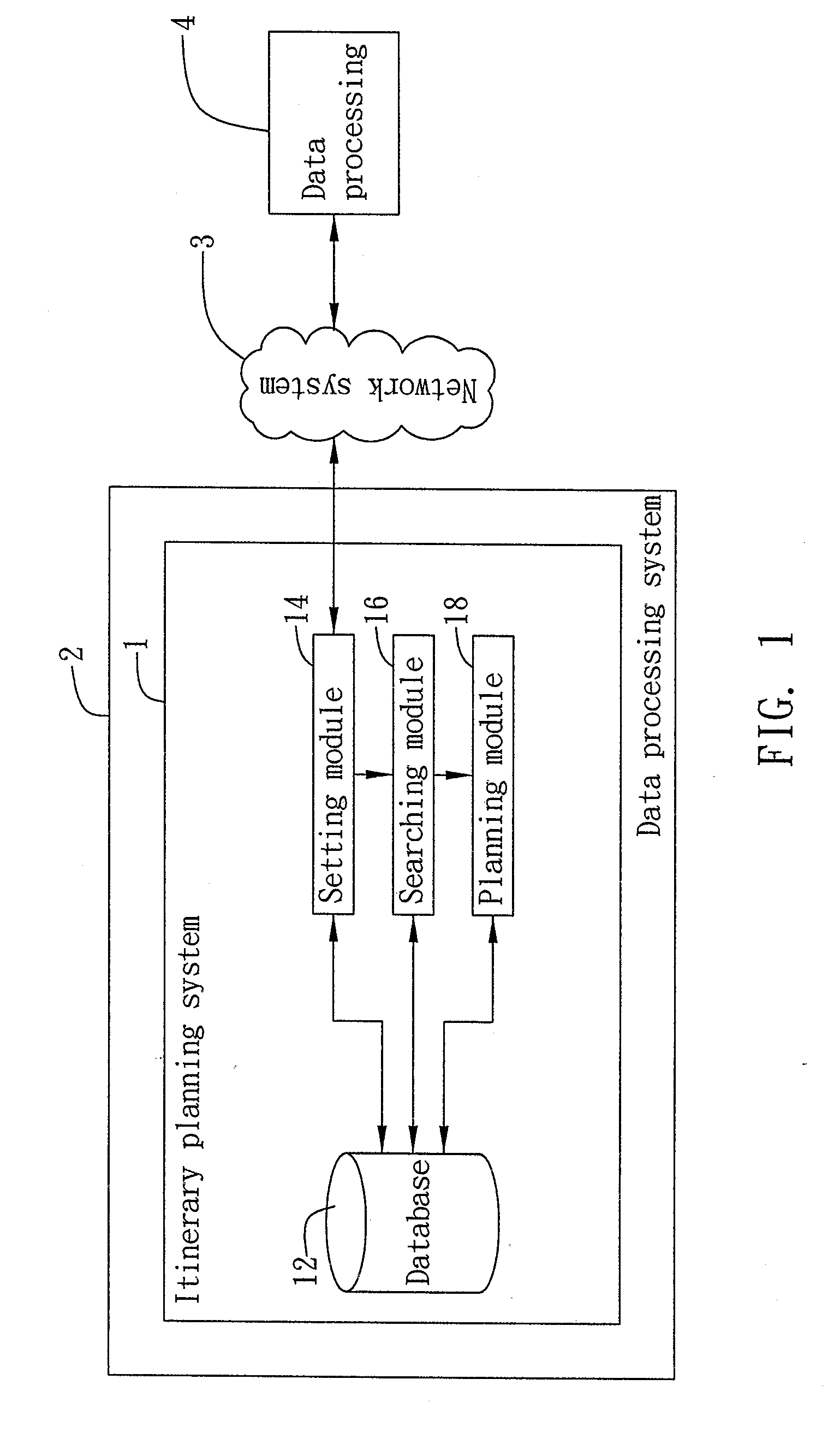
[0018]FIG. 1 is a schematic diagram showing the application configuration of the itinerary planning system in accordance with the present invention. As shown, the itinerary planning system 1 of the present invention is applicable to a data processing system 2, the data processing system 2 being a network platform which interconnects with a data processing device 4 having a network connection and data transmission capability for transmitting data therebetween via a network system 3, wherein the data processing device 4 is a satellite navigation device. In a preferred embodiment of the present inventi...


PUM


Abstract

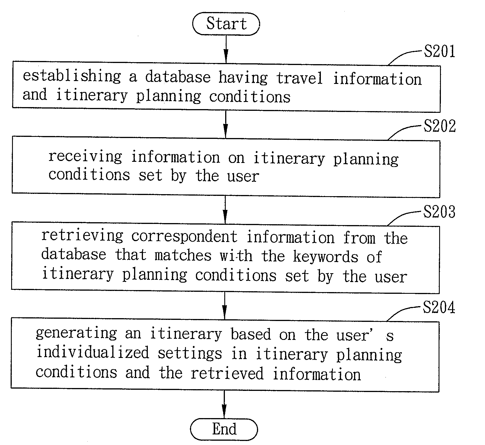
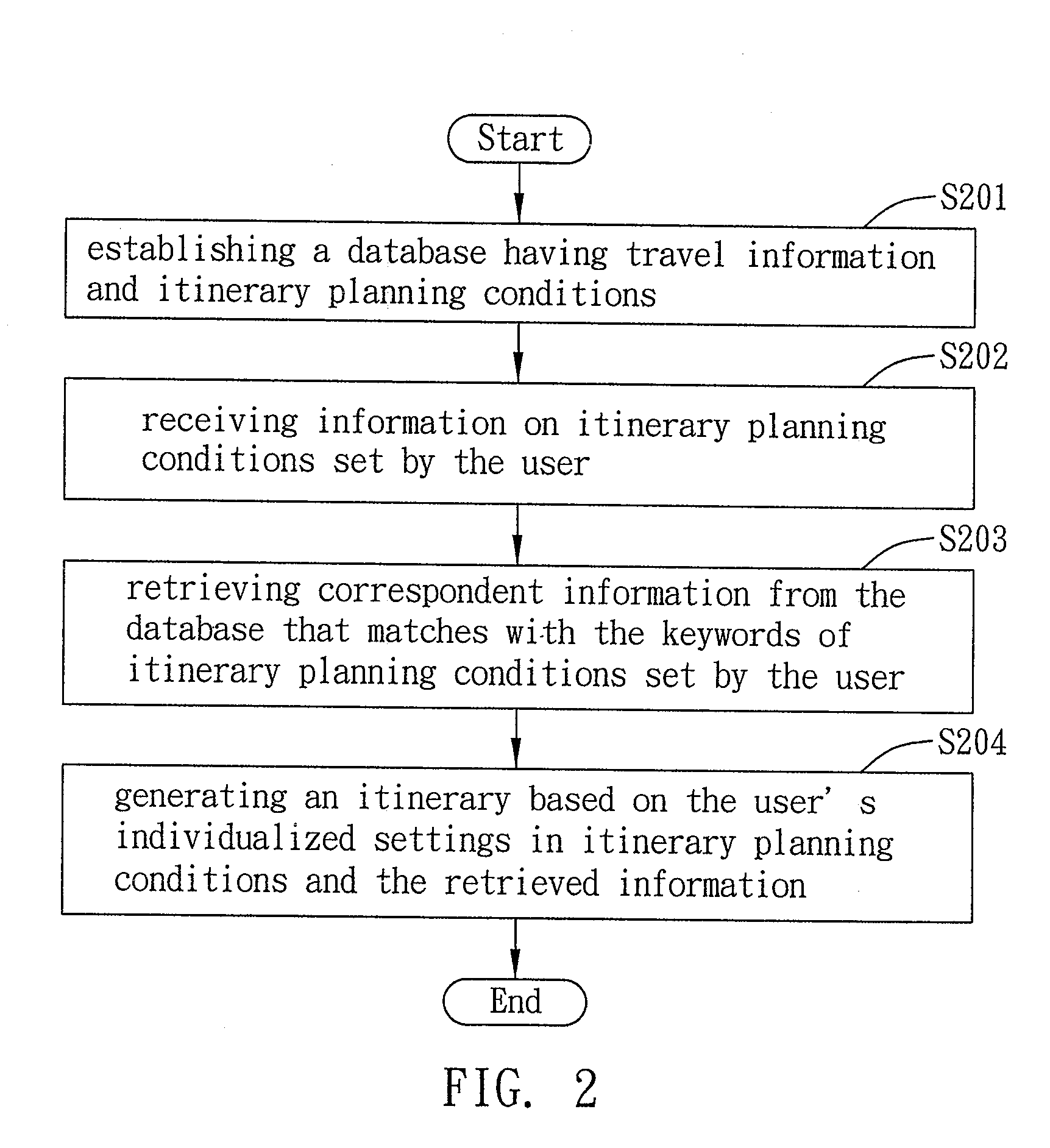
An itinerary planning system and method applicable to data processing systems is proposed, comprising: a database having travel information and itinerary planning conditions; a setting module for receiving information on itinerary planning conditions set by the user; a searching module for retrieving from the database the travel information that corresponds to itinerary planning conditions set by the user; and a planning module for creating an itinerary based on itinerary planning conditions and the correspondent travel information retrieved from the database, thereby building an itinerary from the database according to itinerary planning conditions set by the user.

Description

FIELD OF THE INVENTION[0001]The present invention relates to data processing technologies, and more particularly, to an itinerary planning system and method using data processing technologies.BACKGROUND[0002]The planning of recreational activities has become increasingly important with the expansion of leisure time along with the increase in spendable income. The increasing availability of automobiles and intercity highways makes it convenient for people to travel independently. Also, with the assistance and popularity of recreational vehicles, people nowadays are more accustomed to traveling to scenic spots of interest by driving cars themselves as opposed to commercial transportation.[0003]To find all possible reasonable routes to reach a desired destination, drivers have had to rely on printed maps alone to plan their travel and provide directions. This mode of planning has several disadvantageous, for example, the update of such printed map versions is way too slow to provide th...

Claims


Application Information

Patent Timeline
IPC IPC(8): G06Q10/00
CPCG01C21/3484G06Q10/02
Inventor HUANG, HSING-YUNG
Owner MITAC INT CORP
Learn More