
Method for estimating location of moving object in navigation system

a technology of a navigation system and a moving object, applied in the direction of navigation instruments, process and machine control, instruments, etc., can solve the problems of inaccurate estimation of the traveling direction, affecting the movement of the moving object, and the error of direction sensors such as gyro and electronic compass depending on rotation direction, etc., to achieve accurate estimation

Inactive Publication Date: 2004-04-15
LG ELECTRONICS INC
View PDF12 Cites 56 Cited by
  • Summary
  • Abstract
  • Description
  • Claims
  • Application Information

AI Technical Summary

Benefits of technology

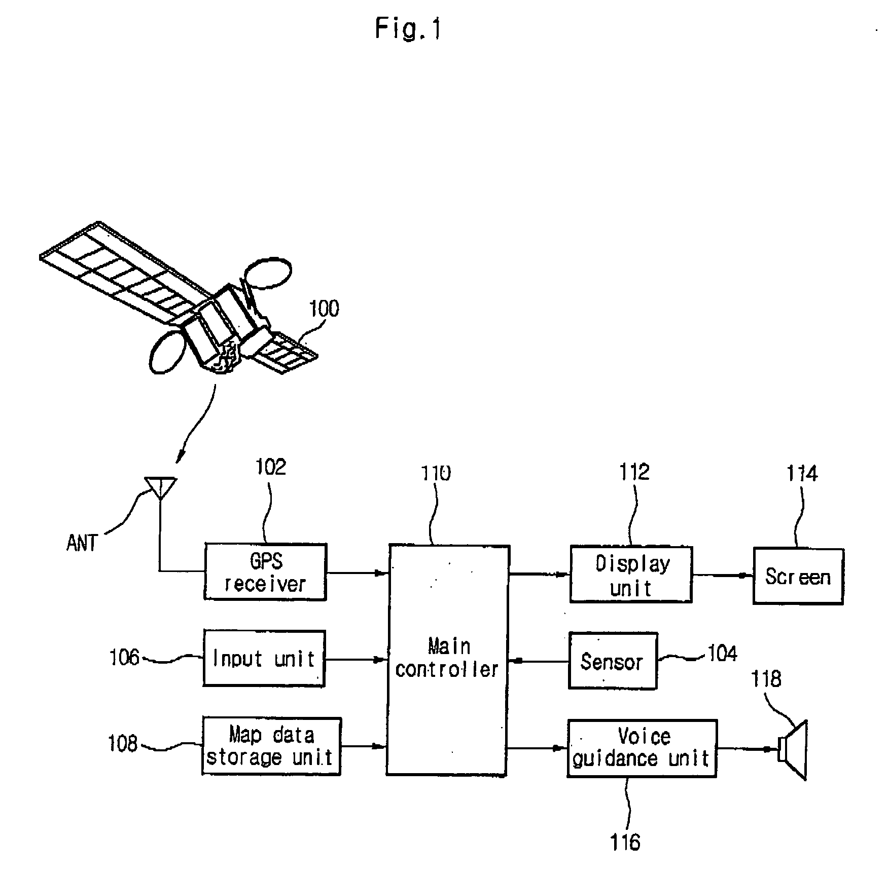
[0016] In the present invention, the location of the moving object in the shadow area is more accurately estimated using parameters such as speed of the moving object traveling to the shadow area, direction of the link at the last map-matching location on the digital numeric map and link and interpolated point on the digital numeric map.

Problems solved by technology

However, the wrong location estimation or the discontinuous location estimation can affect a movement of the moving object seriously.
Without using the dead reckoning technique, direction sensors such as a gyro and an electronic compass may have errors depending on rotation direction.
Therefore, the estimated traveling direction can include an error.
Estimation of moving distance by wheel sensors includes errors due to external elements such as air pressure and street conditions.
Accordingly, it is very difficult to solve instability of location estimation and to provide navigation service such as a map mapping in GPS shadow areas in the navigation system without any direction sensor.
It is not easy to estimate the locations of the moving object such as a mobile telephone having no direction sensors such as a gyro and an electronic compass, and the moving objects in the shadow areas, in which GPS data are not received, and the unreliable regions such as tunnel and underground passage in which quality of the received GPS location data is greatly lowered though the GPS location data is received.
It is very difficult to estimate the location of the moving object precisely due to errors caused during estimation even if the location of the moving object can be estimated.

Method used


Image

  • Method for estimating location of moving object in navigation system
  • Method for estimating location of moving object in navigation system
  • Method for estimating location of moving object in navigation system

Examples


first embodiment

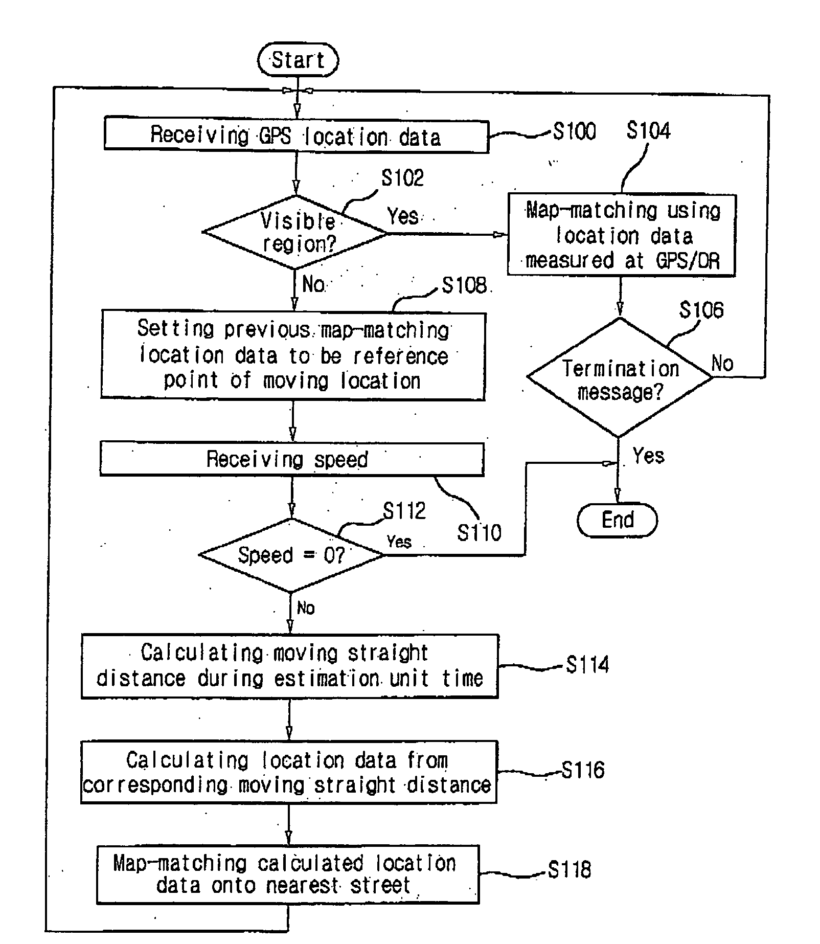
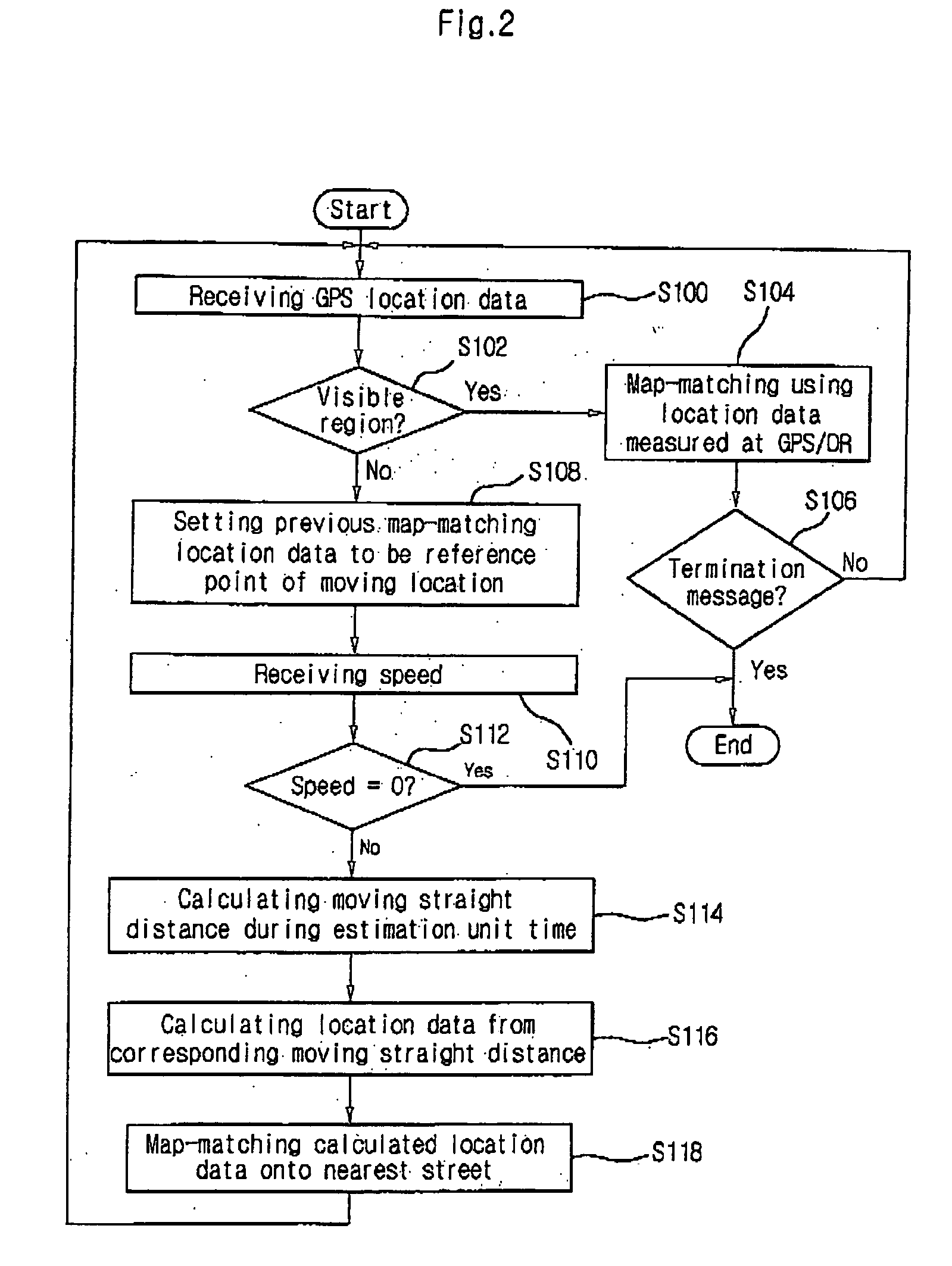
[0034] FIGS. 2 and 3 illustrate the present invention.

[0035] Most of all, referring to FIG. 2, the moving objects receive GPS location data from a plurality of GPS satellites through GPS receivers (S100) and determines whether the moving object is in the visible region or the shadow area by using the GPS location data received through the GPS receiver (S102).

[0036] Here, the criterion to determine whether the moving object is to determine whether the moving object is in the visible region or the shadow area of the GPS location data by using the identifying value on reliability of the received GPS location data. Here, the identifying value on the reliability of the GPS location data is calculated to be HDOP (Horizontal Dilution Of Precision) code by using a calculation algorithm provided from NMEA-6283 format. The calculated HDQP code is compared with a predetermined value. As the result of the comparison, if HDOP is less than the predetermined value, it is determined to be the visib...


PUM


Abstract

The present invention relates to a method for estimating location of a moving object in a navigation system, which is capable of accurately estimating location of the object in a shadow area of GPS location data so that navigation service is provided. A method for estimating location of a moving object in a navigation system includes the steps of: (a) receiving GPS location data from a moving object; (b) determining GPS shadow area by using the received GPS location data; (c) calculating moving straight distance of the moving object with reference to a last GPS location data in visible regions when the moving object is in a GPS shadow area; (d) calculating virtual location data by using the calculated moving straight distance of the moving object; and (e) calculating estimated location on a digital numeric map positioned nearest from the virtual location data, and performing a map-matching to provide a navigation service.

Description

BACKGROUND OF THE INVEMITON[0001] 1. Field of the Invention[0002] The present invention relates to a method for estimating location of a moving object in a navigation system, which is capable of accurately estimating a next location of the object by using a speed of the moving object and a direction of the link on a digital numeric map especially when a moving object (e.g. a vehicle) goes in a shadow area.[0003] 2. Description of the Related Art[0004] Generally, in the navigation system, location information of the moving object is provided continuously in real time within a range of an allowable error and used for the services to display the present location of the moving object, to guide a moving path and to recognize an environment. However, the wrong location estimation or the discontinuous location estimation can affect a movement of the moving object seriously. Therefore, it is very important to estimate the location of the moving object.[0005] The method for estimating the lo...

Claims


Application Information

Patent Timeline
IPC IPC(8): G01C21/30G08G1/00G01S5/14G01S19/49G01S19/50
CPCG01C21/30G01S19/50G01S19/49
Inventor JUNG, MUN HOJOE, MOON JEUNGPARK, YONG HYUNBYUN, SEONG CHAN
Owner LG ELECTRONICS INC
Learn More