
Underwater GPS positioning navigation method and system without high stable frequency scale

A GPS positioning and navigation system technology, applied in the field of underwater GPS positioning and navigation systems, can solve the problems of inability to realize underwater engineering stakeout automation, inability to realize underwater navigation and timing functions, and inability of underwater targets to actively request positioning, etc. The effect of reducing the burden of underwater acoustic data transmission, reducing complexity and improving performance

Inactive Publication Date: 2004-11-17
CHINESE ACAD OF SURVEYING & MAPPING +1
View PDF1 Cites 64 Cited by
  • Summary
  • Abstract
  • Description
  • Claims
  • Application Information

AI Technical Summary

Problems solved by technology

Underwater targets cannot actively request positioning, so underwater navigation and timing functions cannot be realized, and underwater engineering stakeout automation cannot be realized
In particular, high-precision atomic clocks are required underwater, and the positioning error gradually deteriorates over time, which is the biggest flaw of the system

Method used


Image

  • Underwater GPS positioning navigation method and system without high stable frequency scale
  • Underwater GPS positioning navigation method and system without high stable frequency scale
  • Underwater GPS positioning navigation method and system without high stable frequency scale

Examples


Embodiment Construction

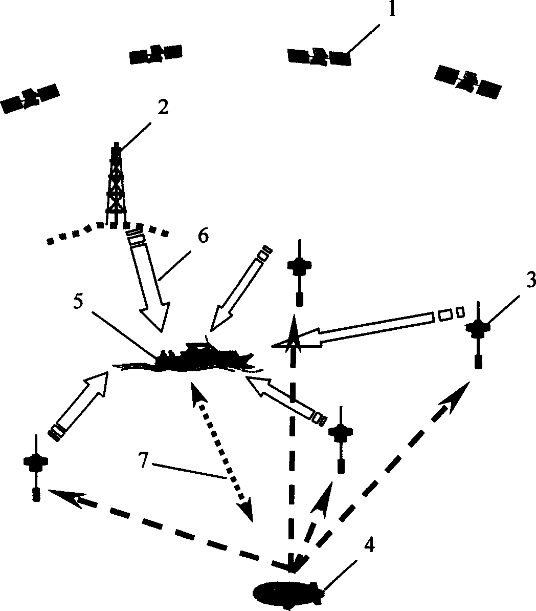
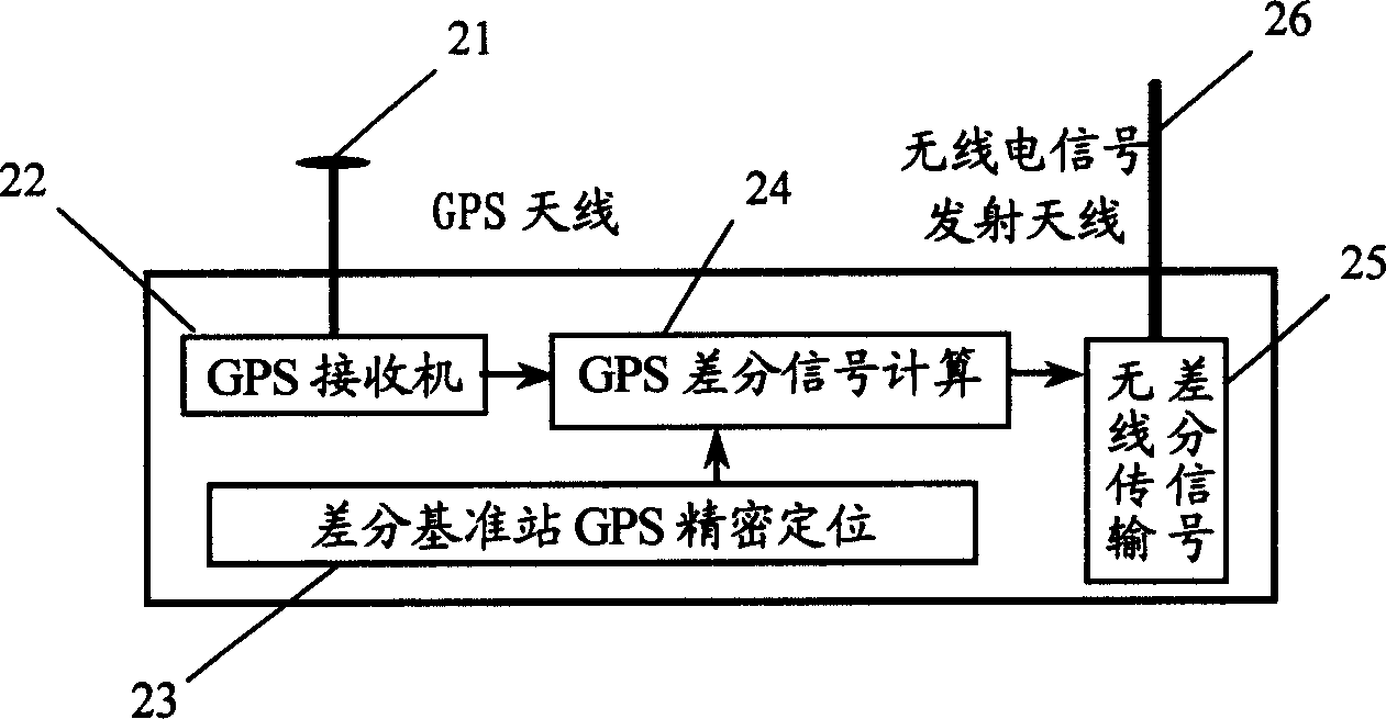
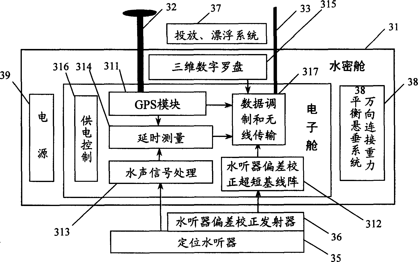
[0037] The underwater DGPS dynamic positioning system without high stable frequency standard of the embodiment of the present invention consists of GPS satellite constellation 1, differential GPS reference station 2, five GPS buoys (one on the ship-based data control center) 3, underwater navigation transceiver 4 , ship-based data control center 5, sea surface radio communication link 6 and underwater underwater acoustic communication link form 7, such as figure 1 shown.

[0038] The underwater positioning method adopted by the system is to use GPS satellite constellations, differential reference stations, and a dynamic space positioning network composed of five or more GPS buoys to establish in real time a sea surface dynamic geodetic reference composed of these GPS buoys to locate hydrophones. Use the buoy GPS receiver clock interface to establish the time reference for underwater positioning; the underwater dynamic space positioning network is composed of the GPS buoy posit...


PUM


Abstract

The invention discloses a kind of underwater GPS allocation and navigation system and method without high stable frequency scale. The system is made up of GPS satellite constellation, four or more GPS floating marks, underwater navigation transceiver, data control centre, sea level wireless communication loop and hydroacoustics communication loop. The method is: when the object underwater needed to be located, the underwater navigation transceiver sends out hydroacoustics localization signal to the GPS floating mark, the floating mark transmits the hydroacoustics localization signal, the GPS signal and the posture calibration data wirelessly to the data control centre, and the data are processed with the difference signal, works out the position and time sending out the localization signal of the underwater object, the position and time data are transmitted to the underwater navigation transceiver by the hydroacoustics communication system, it can carry on navigation or time service. The invention can be applied to underwater object tracing, underwater localization and navigation, underwater precise timer service, measuring project control and project structure sample, it needs no high stable frequency scale.

Description

technical field [0001] The present invention relates to an underwater GPS positioning and navigation system and method without a high-stable frequency standard, in particular, to a dynamic network using several GPS buoys on the sea surface as a sea surface dynamic geodetic reference and time reference for underwater positioning. A method and system for realizing underwater positioning, navigation and timing by utilizing underwater acoustic positioning technology. Background technique [0002] Sea surface and underwater positioning and navigation are the basic prerequisites for all ocean development activities and marine high-tech development. Ocean development requires the acquisition of large-scale and accurate marine environmental data, as well as seabed exploration, sampling, underwater construction, etc. Modern naval warfare has gradually developed into a three-dimensional war involving space, air, sea surface, underwater, and multi-layered submarine space. All of these...

Claims


Application Information

Patent Timeline
Patent Type & Authority Applications(China)
IPC IPC(8): G01S5/18
Inventor 章传银凌国民王泽民秘金钟
Owner CHINESE ACAD OF SURVEYING & MAPPING
Learn More