Fourcolour region number map

A map and color zone technology, applied in maps/plans/charts, instruments, educational tools, etc., can solve the problems that are not suitable for changes in administrative divisions and urban development requirements, and the inconvenience of finding targets on ordinary maps, so as to reduce troubles Effect

Inactive Publication Date: 2004-07-21
张琦
View PDF0 Cites 1 Cited by
  • Summary
  • Abstract
  • Description
  • Claims
  • Application Information

AI Technical Summary

Problems solved by technology

[0004] The technical problem to be solved by the present invention is that the existing ordinary map is inconvenient to find the target, and is not suitable for the change of administrative division and the requirements of urban development.

Method used


Image

  • Fourcolour region number map
  • Fourcolour region number map
  • Fourcolour region number map

Examples


specific Embodiment approach 1

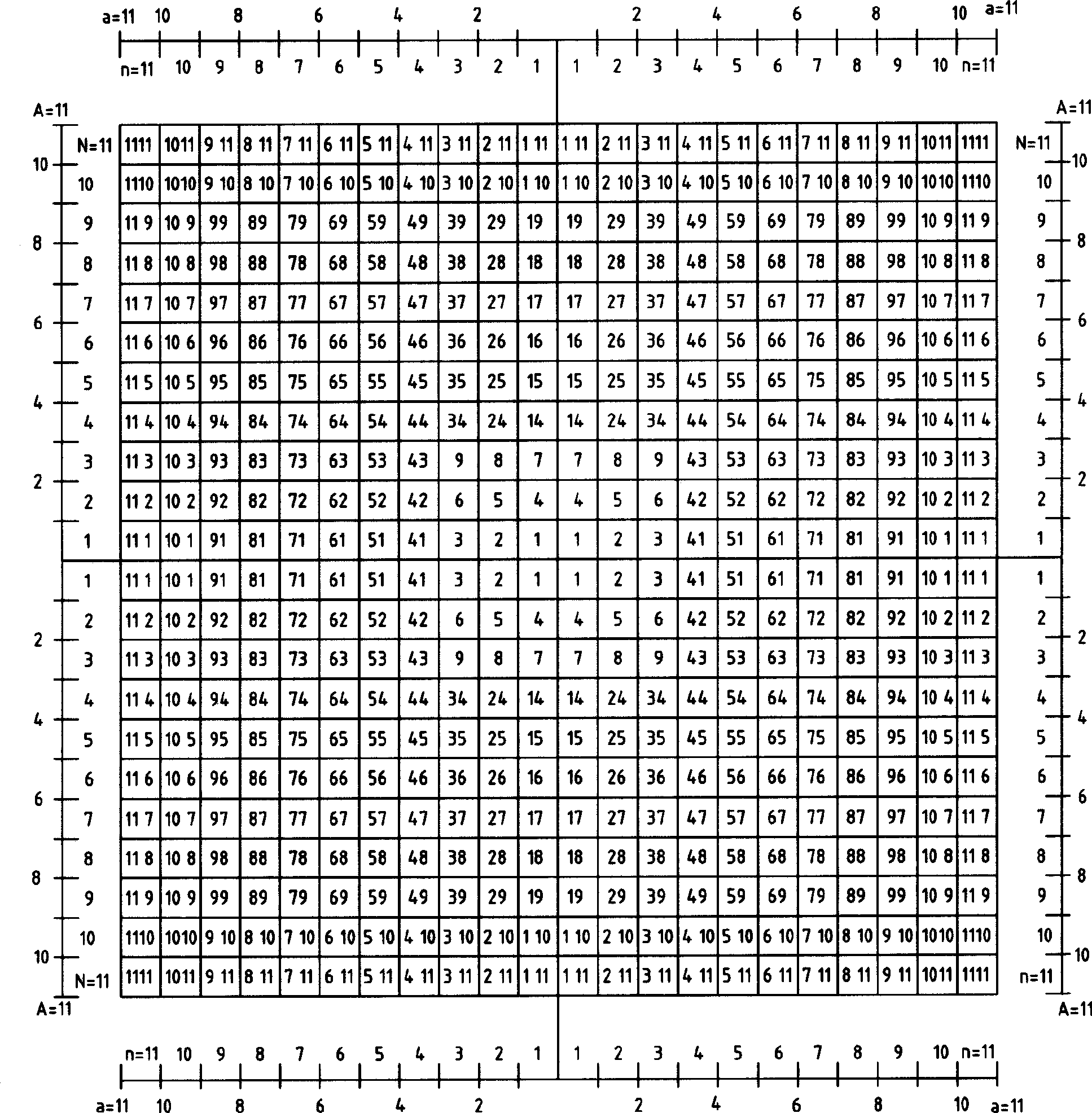
[0017] Such as figure 1 As shown, the surface of the map is divided into four areas marked with different colors by the latitude and longitude coordinate lines, the northeast area is the red area, the northwest area is the blue area, the southwest area is the green area, and the southeast area is the black area. The longitude and latitude coordinate lines used to divide the four major areas are divided into several segments at equal distances, each segment on the longitude coordinate line is marked with an ordinal number N, and each segment on the latitude coordinate line is marked with an ordinal number n. The ordinal number N marked on the left and right sections with the same distance from the origin of coordinates on the longitude coordinate line is the same, and the ordinal number n marked on the upper and lower sections with the same distance from the origin of coordinates on the latitude coordinate is also the same. The edges of each section on the longitude and latitud...

specific Embodiment approach 2

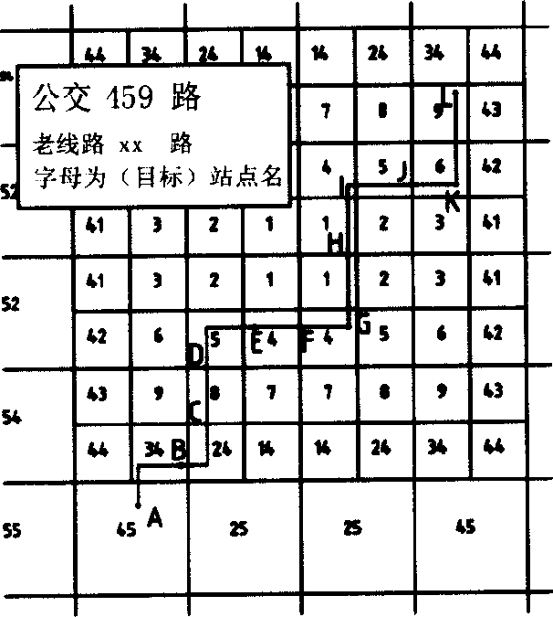
[0024] For different maps, the size and shape of the central area are different, and the size and shape of the total area composed of the four-color sub-areas aA are also different. Generally speaking, the central area (such as the downtown area of ​​a city) is rich in targets and information, and should be represented by short latitude and longitude segments; Less information can be represented by longitude and latitude segments.

[0025] Therefore, in this embodiment, the four-color map is divided into a plurality of circular areas by longitude and latitude segments with different lengths.

[0026] The longitude and latitude section length of the first ring area (central area) is K1, and the ordinal numbers are n1 and N1; (n1 and N1 are natural numbers from 1 to n the same as n and N, and the following n2, N2, n3, N3 are similar)

[0027] The length of the longitude and latitude section of the second ring area is K2, and the ordinal numbers are n2 and N2;

[0028] The leng...


PUM


Abstract

Map face is divided into four parentzones marked with different colors by longitudinal and latitudinal coordinate lines. The longitudinal and latitudinal coordinate lines are divided into several sections. Each section of longitudinal coordinate line is marked by ordinal number N; and each section of latitudinal coordinate line is marked by ordinal number n. Longitude lines or latitude lines parallel to longitudinal and latitudinal coordinate lines pass through edges of each section on longitudinal and latitudinal coordinate lines so that the said four parentzones are divided into many small zones. The invention locates all targets on map within a small zone in blurredness. It is helpful to describe and search target with accuracy and rapidly by the tool provided by the invention so as to reduce trouble caused by language obstruction. The invention is suitable to departments such as city planning, public security, fire fighting, and rescue etc. to make quick response and quick action.

Description

technical field [0001] The invention relates to a four-color area code map. Background technique [0002] Most of the maps now have no orientation recognition method, and it is very inconvenient to find the target point. Partially based on the size of the map, the map that provides numerical and letter coordinates only provides a simple method of azimuth identification. The azimuth identification of the same coordinate point on two different maps is not exactly the same, and the targets outside the map cannot be identified. Reflected, it is not suitable for changes in administrative divisions and urban development. There are also some maps with latitude and longitude, and the latitude and longitude coordinates of the target are unique. This kind of area has extremely high precision, but it is extremely inconvenient in daily use, so it is worse than fuzzy positioning. [0003] In the current map with bus lines, the starting points of each line ar...

Claims


Application Information

Patent Timeline
Patent Type & Authority Applications(China)
IPC IPC(8): G09B29/00
Inventor 张琦张新富
Owner 张琦
Why Eureka
Try Eureka