Ground penetrating radar data accurate positioning method for high-precision terrain correction

A technology of ground penetrating radar and terrain correction, which is applied in the fields of surveying and mapping and underground detection, can solve the problems of radar image interference waves, increase the difficulty of identifying and interpreting target information on radar images, etc., and achieve flexible and convenient detection, strong practicability, Results with high precision

Pending Publication Date: 2022-07-29
WUHAN UNIV
View PDF0 Cites 1 Cited by
  • Summary
  • Abstract
  • Description
  • Claims
  • Application Information

AI Technical Summary

Problems solved by technology

[0003] However, in actual detection, GPR also has technical defects. GPR is easily affected by factors such as data acquisition area conditions (terrain, soil properties, electromagnetic field interference, etc.), system configuration, and measurement methods during data collection. There are many interference waves, which also increase the difficulty of identifying and interpreting target information on radar images to varying degrees

Method used


Image

  • Ground penetrating radar data accurate positioning method for high-precision terrain correction
  • Ground penetrating radar data accurate positioning method for high-precision terrain correction

Examples


Embodiment Construction

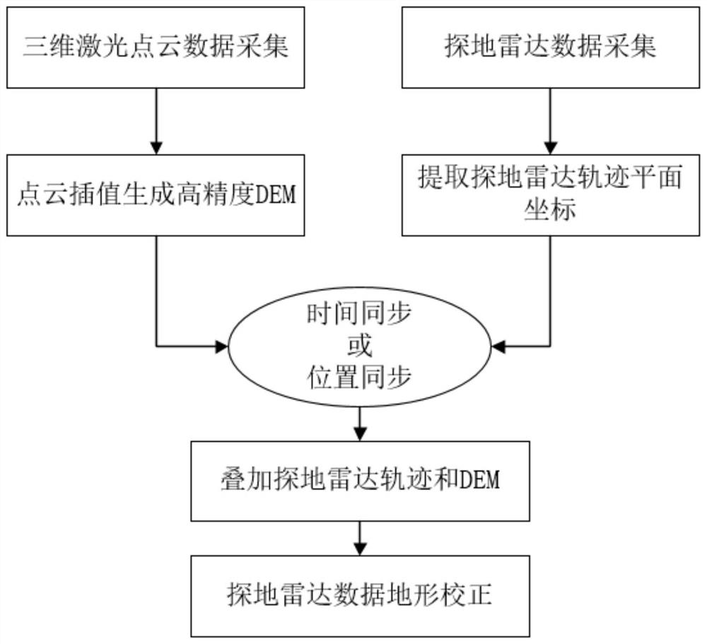
[0035] The present invention will be further illustrated below in conjunction with specific examples. The examples are implemented on the premise of the technical solutions of the present invention. It should be understood that these embodiments are only used to illustrate the present invention and not to limit the scope of the present invention.

[0036] The precise positioning method of ground penetrating radar data for high-precision terrain correction of the present application mainly includes the following steps:

[0037] 1) Establish a relatively independent coordinate system in the area to be detected. In the example, the coordinate system adopts the WGS84 coordinate system synchronized with GNSS, the 3° zone, the central meridian is 114°00′00″, and the projection plane is the average elevation plane of the 23m survey area. Guarantee the accuracy of data results.

[0038] 2) GNSS / IMU solution method, using GNSS / IMU pseudorange and pseudorange rate tight coupling technol...


PUM


Abstract

The invention relates to a high-precision terrain correction ground penetrating radar data accurate positioning method. Comprising the following steps: acquiring a high-precision digital elevation model of a detection area; acquiring underground three-dimensional imaging data of a detection area, and extracting track plane coordinates; superposing the high-precision digital elevation model and the trajectory plane coordinates to obtain trajectory three-dimensional data; and correcting the underground three-dimensional imaging data according to the track three-dimensional data. The method is high in operation efficiency, low in labor investment, high in result precision and high in practicability; a detection track does not need to be set in advance for terrain correction, so that ground penetrating radar detection is more flexible and convenient; and the ground penetrating radar can be used in a complex terrain environment, and the practicability of the ground penetrating radar is improved.

Description

technical field [0001] The invention belongs to the technical field of surveying and mapping and underground detection, and in particular relates to a ground penetrating radar data precise positioning method for terrain correction with high precision. Background technique [0002] Ground Penetrating Radar is a non-destructive measurement technique that uses electromagnetic waves to locate targets or interfaces buried within visually opaque materials or subsurface media. Ground-penetrating radar transmits a regular sequence of low-power electromagnetic energy to material or the ground, and receives and detects weak reflections from buried targets. Buried targets can be conductors, dielectrics, or a combination of both. GPR uses propagating electromagnetic waves to respond to changes in the electromagnetic properties of the shallow subsurface. The propagation speed of the electromagnetic wave is the main controlling factor in the generation of reflections, which is determine...

Claims


Application Information

Patent Timeline
IPC IPC(8): G01V3/12G01V3/38G01C5/00G01C15/00G01S19/47
CPCG01V3/12G01V3/38G01C5/00G01C15/00G01S19/47
Inventor 赵鹏程胡庆武艾明耀张菊
Owner WUHAN UNIV
Why Eureka
Try Eureka