Corn damage degree discrimination method based on remote sensing technology

A discriminant method and remote sensing technology, applied in the field of agricultural remote sensing, can solve problems such as the inability to quantitatively obtain the degree of corn drought damage

Inactive Publication Date: 2022-05-03
自然资源部第一航测遥感院(陕西省第五测绘工程院)
View PDF4 Cites 1 Cited by
  • Summary
  • Abstract
  • Description
  • Claims
  • Application Information

AI Technical Summary

Problems solved by technology

However, at present, it is impossible to quickly and quantitatively obtain the drought damage degree of maize by relying on the commonly used remote sensing growth monitoring methods.

Method used


Image

  • Corn damage degree discrimination method based on remote sensing technology
  • Corn damage degree discrimination method based on remote sensing technology
  • Corn damage degree discrimination method based on remote sensing technology

Examples


Embodiment Construction

[0020] A specific embodiment of the present invention will be described in detail below in conjunction with the accompanying drawings, but it should be understood that the protection scope of the present invention is not limited by the specific embodiment.

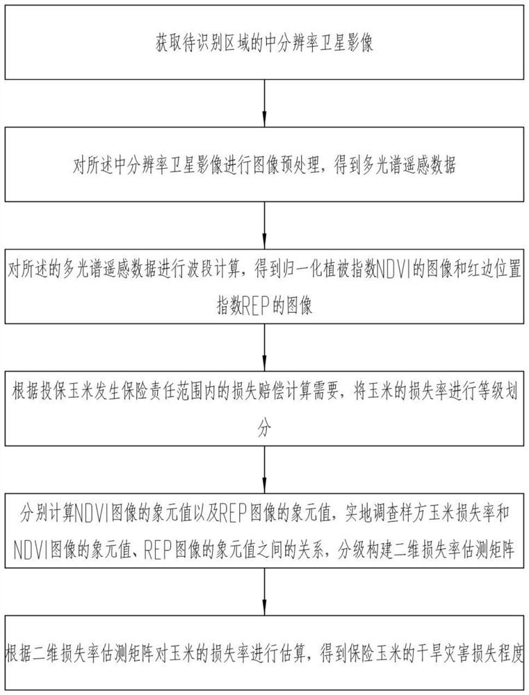
[0021] Specifically, such as figure 1 As shown, the embodiment of the present invention provides a method for discriminating the degree of corn damage based on remote sensing technology, including the following steps:

[0022] Step 1: Acquire medium-resolution satellite images of the area to be identified;

[0023] The medium-resolution satellite images in the present invention mainly use Sentinel-2 remote sensing images, which should be the latest time-phase images after the drought disaster occurs.

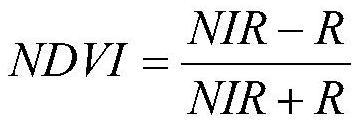
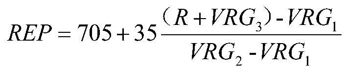
[0024] Step 2: performing image preprocessing on the medium-resolution satellite image to obtain multispectral remote sensing data;

[0025] Image preprocessing is mainly to combine the 2nd, 3rd, 4th, 5th, 6th, 7th, 8th, 8...


PUM


Abstract

The invention discloses a corn damage degree discrimination method based on a remote sensing technology, and the method comprises the steps: carrying out the image preprocessing of a medium-resolution satellite image, obtaining multispectral remote sensing data, obtaining an image of a normalized difference vegetation index (NDVI) and an image of a red edge position index (REP), carrying out the grading of the loss rate of corn, constructing a two-dimensional loss rate estimation matrix, and carrying out the recognition of the damage degree of corn. And estimating the loss rate of the corn according to the two-dimensional loss rate estimation matrix to obtain the drought disaster loss degree of the insurance corn. According to the method, the corn drought damage degree is evaluated by using a remote sensing technology, so that the occurrence range and the damage degree of the corn drought disaster can be efficiently, quickly, accurately and economically obtained in a short time under the condition that manpower, material resources and financial resources are limited, and a support basis is provided for nuclear protection loss assessment of the corn drought disaster.

Description

technical field [0001] The invention relates to the technical field of agricultural remote sensing, in particular to a method for judging the damage degree of corn based on remote sensing technology. Background technique [0002] Corn is the food crop with the largest planting area and output in my country, and occupies an important position in the national economic production. Drought disasters are the main factors that restrict the increase of corn production and limit the quality of corn. With the intensification of global warming, the decrease in precipitation and the continuous increase in the frequency of drought periods lead to frequent occurrence of drought disasters in corn, and other harmful effects such as high salinity, high temperature and diseases Impacts will follow, causing huge losses and impacts on regional food production. Corn planting insurance is a main insurance content of agricultural policy insurance, which is of great significance to protect farmer...

Claims


Application Information

Patent Timeline
Patent Type & Authority Applications(China)
IPC IPC(8): G06T7/00G06V20/13
CPCG06T7/0002G06T2207/10032G06T2207/30188
Inventor 陈思宇成王玉刘莉
Owner 自然资源部第一航测遥感院(陕西省第五测绘工程院)
Why Eureka
Try Eureka