Unmanned aerial vehicle navigation docking method based on distance measurement

A technology for distance measurement and drones, applied in non-electric variable control, three-dimensional position/channel control, instruments, etc., can solve the problems that the accuracy depends on the signal, and it is difficult to guarantee the accuracy of drone navigation and docking, so as to ensure the accuracy , save deployment and maintenance costs, and save calculations

Active Publication Date: 2022-04-22
TONGJI UNIV
View PDF8 Cites 0 Cited by
  • Summary
  • Abstract
  • Description
  • Claims
  • Application Information

AI Technical Summary

Problems solved by technology

[0005] Although the above method can complete the task of UAV autonomous landing in many cases, in the above autonomous docking scheme, UAV needs to rely on GPS position information or vehicle odometer position information, which largely depends on whether there is GPS coverage. And the accuracy also depends on the strength of the signal
In fact, GPS cannot be used in many places, such as indoors, canyons, forests, caves or deep wells. Therefore, in an environment without GPS and without a vehicle odometer, it is difficult to guarantee the accuracy of UAV navigation docking by using the above methods

Method used


Image

  • Unmanned aerial vehicle navigation docking method based on distance measurement
  • Unmanned aerial vehicle navigation docking method based on distance measurement
  • Unmanned aerial vehicle navigation docking method based on distance measurement

Examples


Embodiment

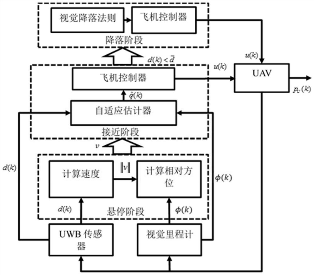
[0062] like figure 1 As shown, a UAV navigation docking method based on distance measurement, including the following steps:

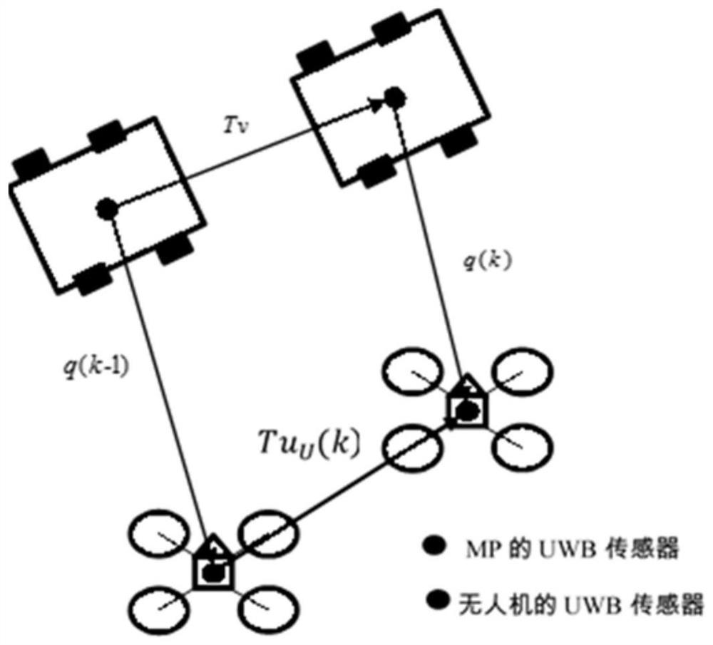
[0063] S1. Obtain the distance information between the UAV and the MP, and the displacement of the MP. Among them, the distance information between the UAV and the MP is acquired through UWB sensors, and the UWB sensors are respectively installed on the UAV and the MP. superior;

[0064] The displacement of MP is specifically collected and obtained through the visual odometer, which is installed on the UAV;

[0065] S2. According to the distance information and the displacement obtained in step S1, the velocity of the MP and the relative position between the UAV and the MP are respectively calculated during the hovering phase;

[0066] S3, according to the distance information between the current drone and the MP, and the displacement of the current MP, combined with the speed of the MP obtained in step S2, and the relative position between the drone...


PUM


Abstract

The invention relates to an unmanned aerial vehicle navigation docking method based on distance measurement. The method comprises the following steps: acquiring distance information between an unmanned aerial vehicle and an MP and MP displacement; the speed of the MP and the relative position between the unmanned aerial vehicle and the MP are calculated in the hovering stage; according to the current distance information between the unmanned aerial vehicle and the MP, the MP displacement, the MP speed and the relative position between the unmanned aerial vehicle and the MP, a relative position estimation value is determined in the approaching stage, and a corresponding control instruction is output to the unmanned aerial vehicle; in the approaching stage, whether the distance information between the current unmanned aerial vehicle and the MP is smaller than a set distance threshold value or not is judged in real time, if yes, a landing stage is started, and landing control over the unmanned aerial vehicle is carried out based on a visual landing rule; otherwise, the relative position estimation value is continuously updated in the approaching stage and is correspondingly controlled. Compared with the prior art, autonomous docking of the unmanned aerial vehicle can be accurately and reliably realized in a GPS-free environment, and the method has the advantages of being low in deployment cost, wide in application range, capable of saving computing resources and the like.

Description

technical field [0001] The invention relates to the technical field of drone docking, in particular to a distance measurement-based navigation docking method for drones. Background technique [0002] In recent years, the autonomous docking of unmanned aerial vehicle (UAV, Unmanned Aerial Vehicle, unmanned aircraft) has been a hot research field, generally speaking, it includes two phases: approach phase and landing phase. First, the UAV needs to perform relative positioning on the target, where the target can be a fixed landing point, such as a manned or unmanned ground vehicle, or a ship at sea. Secondly, when the relative position is determined, it needs to navigate according to the navigation rules. When the target enters the field of vision of the drone, the drone will land in the set target area. Traditionally, because the airborne vision system can provide rich and accurate position information, it has been widely used in navigation and positioning. Currently, the mai...

Claims


Application Information

Patent Timeline
Patent Type & Authority Applications(China)
IPC IPC(8): G05D1/10
CPCG05D1/106
Inventor 程诚李修贤李莉
Owner TONGJI UNIV
Why Eureka
Try Eureka