Multi-dimensional drawing method for engineering geological profile map

A technology of engineering geology and geological profile, applied in the field of engineering geological survey, can solve the problems of irregular drawing of geological profiles and low degree of digital application, and achieve the effect of realizing digital delivery and improving the efficiency of engineering design.

Pending Publication Date: 2022-04-15
CHINA RAILWAY FIRST SURVEY & DESIGN INST GRP
View PDF0 Cites 0 Cited by
  • Summary
  • Abstract
  • Description
  • Claims
  • Application Information

AI Technical Summary

Problems solved by technology

[0003] The purpose of the present invention is to provide a multi-dimensional drawing method of engineering geological profile, which overcomes the problems of non-standard drawing of geological profile and low degree of digital application in the prior art, and provides data basis for automatic design to achieve geological Section digital delivery purpose, greatly improving the efficiency of engineering design

Method used


Image

  • Multi-dimensional drawing method for engineering geological profile map
  • Multi-dimensional drawing method for engineering geological profile map
  • Multi-dimensional drawing method for engineering geological profile map

Examples


Embodiment Construction

[0034] In order to make the object, technical solution and advantages of the present invention more clear, the present invention will be further described in detail below in conjunction with the accompanying drawings and embodiments. It should be understood that the specific embodiments described here are only used to explain the present invention, not to limit the present invention.

[0035] The multi-dimensional drawing method of the engineering geological profile of the present invention specifically includes the following steps:

[0036] Step 001, drilling data preprocessing;

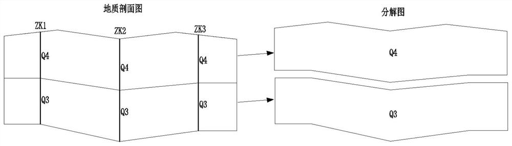
[0037] Step 002, drawing stratigraphic age geological block A;

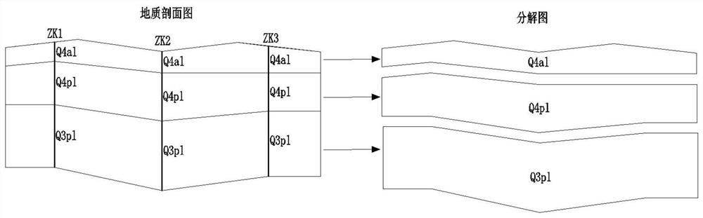
[0038] Step 003, drawing stratigraphic age genetic geological block B;

[0039] Step 004, drawing stratigraphic age genetic lithology geological block C;

[0040] Step 005, drawing the geological block D of the genetic lithology state of the stratum age;

[0041] Step 006, managing the structural tree of the geological profile;

...


PUM


Abstract

According to the multi-dimensional drawing method for the engineering geological profile map, the problems that in the prior art, geological profile map drawing is not standard, and the digital application degree is low are solved, a data basis is provided for automatic design, the purpose of digital delivery of the geological profile is achieved, and the engineering design efficiency is greatly improved. Comprising the following steps: step 001, preprocessing drilling data; step 002, drawing a geological block A of the stratum era; step 003, drawing formation age cause geological blocks B; step 004, drawing a formation age cause lithologic geological block C; step 005, drawing a formation age cause lithologic state geological block D; step 006, geological profile map structure tree management; step 007, post-processing the geological profile; and step 008, outputting four types of data interfaces A, B, C and D of the geological blocks.

Description

Technical field: [0001] The invention belongs to the technical field of engineering geological survey, and relates to a multi-dimensional drawing method of engineering geological profile. Background technique: [0002] A geological section, also known as a geological section, is a map that shows the strata and structural forms at a certain depth on the surface along the vertical direction. In the traditional geological section filling process, the bottom boundary line of the stratum is usually used to divide the space into different areas, and text labels are added to represent different stratum lithology. The advantage of this method is that it is more convenient and flexible when drawing manually. The disadvantage is that Each geological block is composed of different geological boundaries. The space is not an independent geometric form, and there is no unique geometric boundary. It is very difficult to automatically identify geological information through computer technol...

Claims


Application Information

Patent Timeline
IPC IPC(8): G06T11/20
Inventor 张坤刘彦明贾兴斌许兴旺李宗建何守旺马腾张文忠周福军柏青
Owner CHINA RAILWAY FIRST SURVEY & DESIGN INST GRP
Why Eureka
Try Eureka