Method and device for examining drainage system design in architectural drawing
A technology for architectural drawings and drainage systems, applied in design optimization/simulation, geometric CAD, etc., can solve problems such as low efficiency of manual review, and achieve the effect of improving review efficiency and making errors less prone to errors
- Summary
- Abstract
- Description
- Claims
- Application Information
AI Technical Summary
Problems solved by technology
Method used
Image
Examples
Embodiment 1
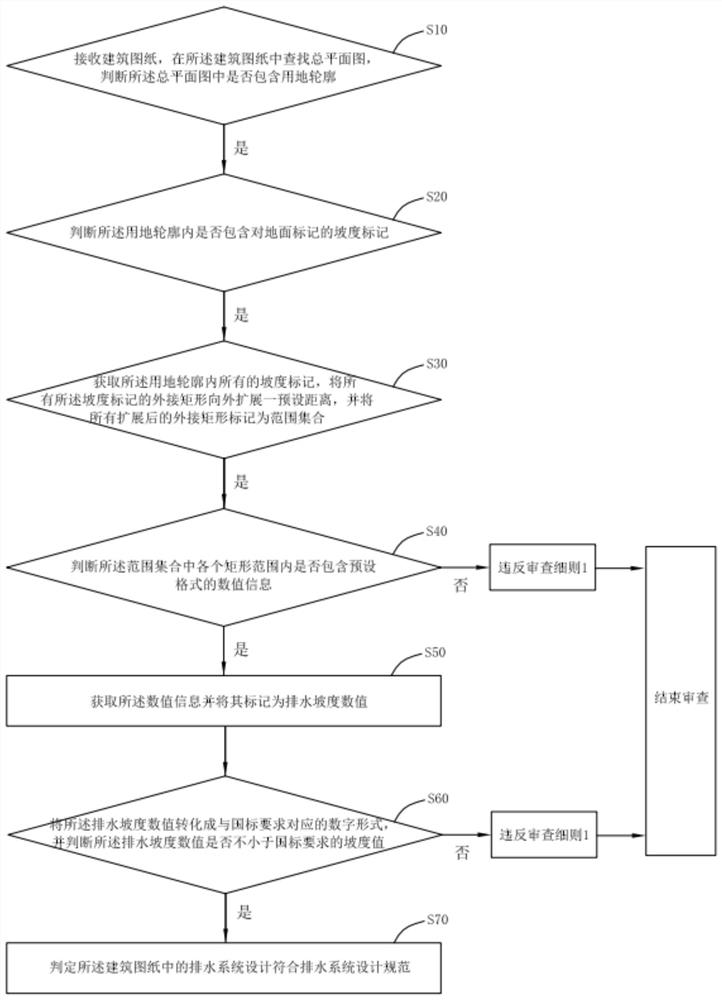
[0054] See figure 1 , The first embodiment of the present invention provides a review method for the design of the drainage system in architectural drawings, the method comprising steps S10-S70:
[0055] Step S10, receive the architectural drawing, find the total plan view in the architectural drawing, and determine whether or not the land is contained in the total plan view;
[0056] Among them, architectural paper, for example, including a general plan view and a faculty, and the review method provided in this embodiment is to review the drainage system design, so we should find the total plan view in the architectural drawing, thus performing the drainage system design based on the total plan view. Review.
[0057] Among them, the land contour is a connection from some of the coordinate points from a certain plot, usually in the form of red line, also known as the land area of the land use, and the land area of the land area is the land use of land use.
[0058] End the revie...
Embodiment 2
[0073] A second embodiment of the present invention provides a review method of the design of drainage system in architectural drawings, in the method shown in this example:
[0074] Before it is determined whether or not the step of the land profile is included in the total plan, the method further includes step S01:
[0075] In step S01, the layered layer of the editable form is analyzed, acquire all attribute information of the land layer, and draw the land profile marker according to the attribute information and stored within the preset database;
[0076] Among them, an editable form is, for example, a CAD drawing of a DWG format, analyzes all of the map information of the land layer, and draws the landline marker according to the acquired element information by parsing the land layer. The use of land contour is stored.
[0077] Among them, it is judged whether or not the step of the main plan includes the step of the land contour, and specifically includes step S11:
[0078]...
Embodiment 3
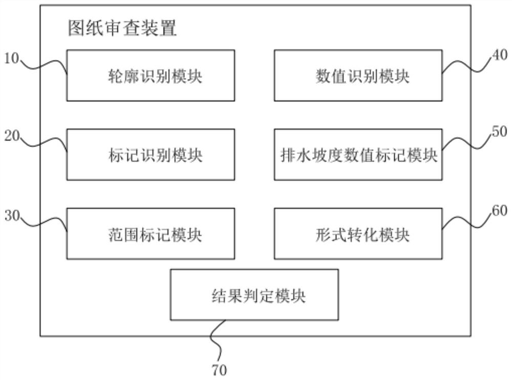
[0099] See figure 2 The third embodiment of the present invention provides a review device for the design of drainage system in architectural drawings, including:
[0100] The contour recognition module 10 is configured to receive a building drawing, and find a total plan view in the architectural drawing to determine whether or not the land is included in the total plan.
[0101] Among them, architectural paper, for example, including a general plan view and a faculty, and the review method provided in this embodiment is to review the drainage system design, so we should find the total plan view in the architectural drawing, thus performing the drainage system design based on the total plan view. Review.
PUM
 Abstract
Description
Claims
Application Information
 - R&D
- Intellectual Property
- Life Sciences
- Materials
- Tech Scout
- Unparalleled Data Quality
- Higher Quality Content
- 60% Fewer Hallucinations
Browse by: Latest US Patents, China's latest patents, Technical Efficacy Thesaurus, Application Domain, Technology Topic, Popular Technical Reports.
© 2025 PatSnap. All rights reserved.Legal|Privacy policy|Modern Slavery Act Transparency Statement|Sitemap|About US| Contact US: help@patsnap.com


