Unmanned aerial vehicle remote sensing information acquisition method and device

A technology of information collection and machine-based remote sensing, applied in three-dimensional position/channel control, vehicle position/route/height control, non-electric variable control, etc., can solve problems such as poor understanding of crop growth in farmland

Pending Publication Date: 2022-02-18
长沙乐源土地规划设计有限责任公司
View PDF0 Cites 0 Cited by
  • Summary
  • Abstract
  • Description
  • Claims
  • Application Information

AI Technical Summary

Problems solved by technology

[0003] At present, the application of drones in agriculture is generally to take pictures and samples of farmland, monitor diseases and insect pests, etc., but the growth of farmland crops cannot be well understood

Method used


Image

  • Unmanned aerial vehicle remote sensing information acquisition method and device
  • Unmanned aerial vehicle remote sensing information acquisition method and device

Examples


Embodiment Construction

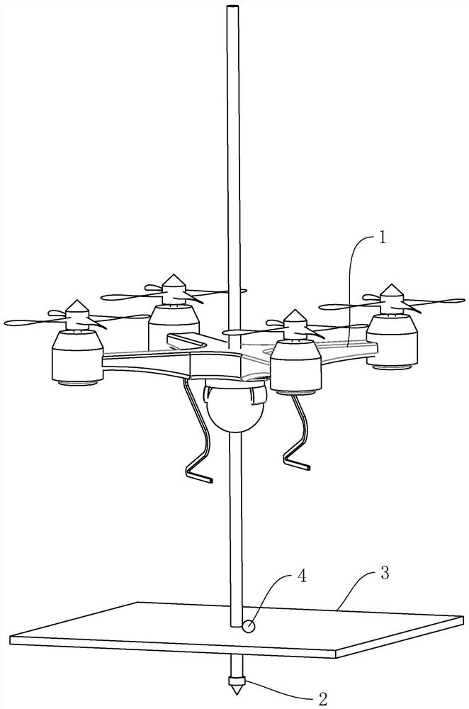
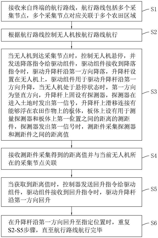
[0042] In order to enable ordinary persons in the art to better understand the technical solutions of the present disclosure, the technical solutions in the embodiments of the present disclosure will be clearly and completely described below in conjunction with the accompanying drawings.

[0043] It should be noted that the terms "first" and "second" in the present invention are used to distinguish similar objects, but not necessarily used to describe a specific order or sequence. It is to be understood that the data so used are interchangeable under appropriate circumstances such that the embodiments of the disclosure described herein can be practiced in sequences other than those illustrated or described herein. The implementations described in the following exemplary examples do not represent all implementations consistent with the present disclosure.

[0044] In addition, the term "and / or" in the present invention is only an association relationship describing associated o...


PUM


Abstract

The invention relates to the technical field of unmanned aerial vehicle information collection, in particular to an unmanned aerial vehicle remote sensing information collection method and device, and the device comprises a terminal which generates a navigation route according to a selection instruction and sends the navigation route to a controller, the controller that controls the unmanned aerial vehicle to sail according to the sailing route, the unmanned aerial vehicle provided with a lifting rod and a driving mechanism, a detector fixedly arranged on the lifting rod and sending out a first signal when entering the land, a plate body connected to the lifting rod in a sliding mode, and being able to float on farmland crops, and a distance measuring piece that collects a distance value between the detector and the distance measuring piece when the detector sends out the first signal; the controller is further used for controlling the unmanned aerial vehicle to hover when the unmanned aerial vehicle arrives at the collection node and sending a landing instruction to the driving assembly, and the driving assembly drives the lifting rod to land in the first direction. The crop height acquisition device has the effect of acquiring the crop height of the farmland so as to know the crop growth condition of the farmland.

Description

technical field [0001] The invention relates to the technical field of UAV information collection, in particular to a method and device for UAV remote sensing information collection. Background technique [0002] Unmanned aircraft, referred to as "unmanned aerial vehicle", or "UAV" in English, is an unmanned aircraft that is controlled by radio remote control equipment and its own program control device, or is completely or intermittently operated autonomously by an on-board computer. Drones are often better suited for missions that are too "dumb, dirty or dangerous" than manned aircraft. According to the application field, UAV can be divided into military and civilian. In terms of military use, UAVs are divided into reconnaissance aircraft and target aircraft. In terms of civilian use, drones + industry applications are the real rigid needs of drones; in aerial photography, agriculture, plant protection, miniature selfies, express transportation, disaster relief, observin...

Claims


Application Information

Patent Timeline
IPC IPC(8): G05D1/10
CPCG05D1/101
Inventor 郑贱成仇应山
Owner 长沙乐源土地规划设计有限责任公司
Why Eureka
Try Eureka