Landslide geological disaster remote sensing interpretation method and device, equipment and storage medium

A technology of geological disasters and disasters, applied in the field of image processing, can solve problems such as poor recognition and extraction effects, and achieve the effect of improving the interpretation effect

Pending Publication Date: 2021-11-26
GUANGZHOU POWER SUPPLY BUREAU GUANGDONG POWER GRID CO LTD
View PDF0 Cites 2 Cited by
  • Summary
  • Abstract
  • Description
  • Claims
  • Application Information

AI Technical Summary

Problems solved by technology

[0005] The invention provides a landslide geological disaster remote sensing interpretation method, device, equipment and storage medium, which are used to solve the technical problem that the existing landslide geological disaster remote sensing interpretation method has poor identification and extraction effects

Method used


Image

  • Landslide geological disaster remote sensing interpretation method and device, equipment and storage medium
  • Landslide geological disaster remote sensing interpretation method and device, equipment and storage medium
  • Landslide geological disaster remote sensing interpretation method and device, equipment and storage medium

Examples


Embodiment Construction

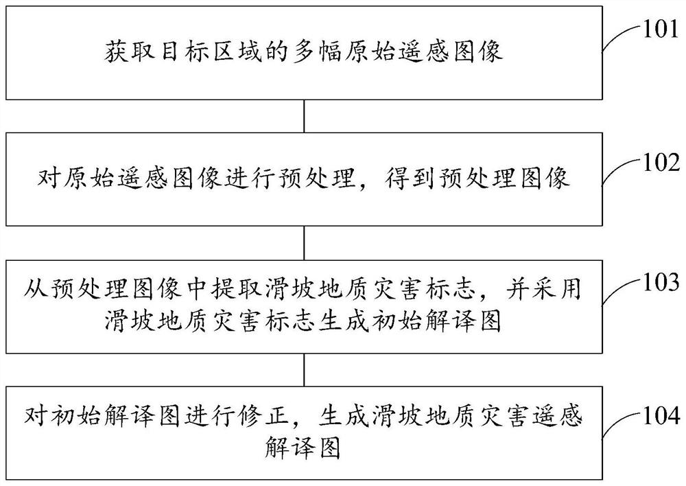
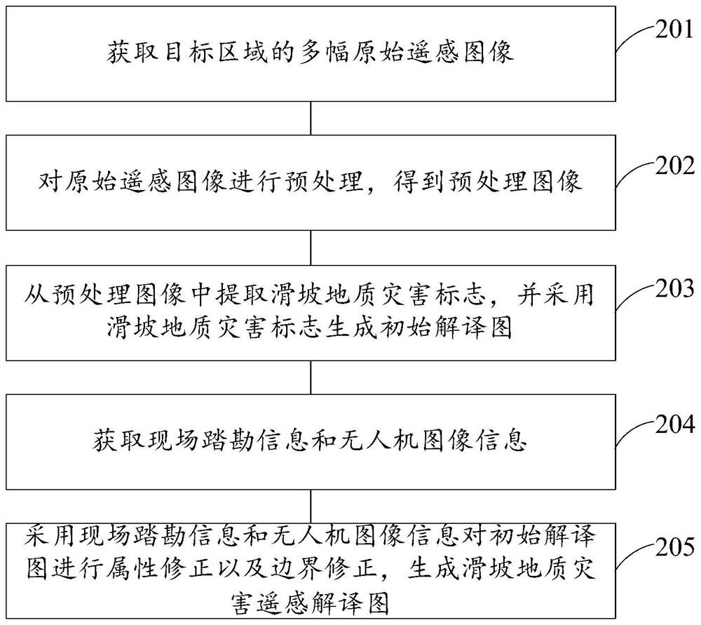
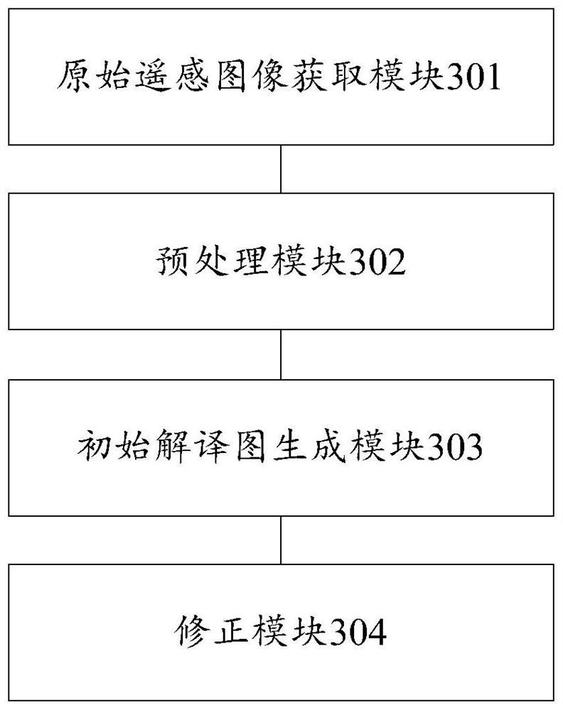
[0055] Embodiments of the present invention provide a landslide geological disaster remote sensing interpretation method, device, equipment and storage medium, which are used to solve the technical problem that the existing landslide geological disaster remote sensing interpretation method has poor identification and extraction effects.

[0056] In order to make the purpose, features and advantages of the present invention more obvious and understandable, the technical solutions in the embodiments of the present invention will be clearly and completely described below in conjunction with the accompanying drawings in the embodiments of the present invention. Obviously, the following The described embodiments are only some, not all, embodiments of the present invention. Based on the embodiments of the present invention, all other embodiments obtained by persons of ordinary skill in the art without making creative efforts belong to the protection scope of the present invention.

...


PUM


Abstract

The invention discloses a landslide geological disaster remote sensing interpretation method and device, equipment and a storage medium, and is used for solving the technical problem that an existing landslide geological disaster remote sensing interpretation method is poor in recognition and extraction effect. The method comprises the following steps: acquiring a plurality of original remote sensing images of a target area; preprocessing the original remote sensing image to obtain a preprocessed image; extracting landslide geological disaster marks from the preprocessed image, and generating an initial interpretation map by using the landslide geological disaster marks; and correcting the initial interpretation map to generate a landslide geological disaster remote sensing interpretation map.

Description

technical field [0001] The invention relates to the technical field of image processing, in particular to a landslide geological disaster remote sensing interpretation method, device, equipment and storage medium. Background technique [0002] Among all kinds of geological disasters, landslide geological disasters have large scale, high frequency, wide distribution and large number; in addition, the destruction of landslide geological disasters is devastating. is of great significance. [0003] Remote sensing refers to a technology for identifying, classifying, interpreting and analyzing target objects without directly contacting them based on the theory of electromagnetic radiation. With the continuous development of remote sensing satellite technology, optical satellite images are gradually introduced into landslide disaster research, and landslide remote sensing survey technology has developed rapidly. The application of high-precision remote sensing satellite technolog...

Claims


Application Information

Patent Timeline
IPC IPC(8): G06K9/00G06K9/46G06K9/62
CPCG06F18/251
Inventor 栾乐范伟男莫文雄王勇刘俊翔许中王海靖周凯
Owner GUANGZHOU POWER SUPPLY BUREAU GUANGDONG POWER GRID CO LTD
Why Eureka
Try Eureka