Map image data real-time acquisition system and method

A technology of image data and image data, applied in image communication, closed-circuit television system, details involving image processing hardware, etc., can solve the problems of high implementation cost, inflexible parameter adjustment, and high cost of panoramic cameras

Pending Publication Date: 2021-09-07
ALIBABA GRP HLDG LTD
View PDF0 Cites 0 Cited by
  • Summary
  • Abstract
  • Description
  • Claims
  • Application Information

AI Technical Summary

Problems solved by technology

Although this method will not cause the CPU load to be too high, the process of data collection involves multi-computer communication, and the implementation cost is relatively high.
[0005] 2. In the high-precision map data acquisition stage, use a highly integrated image acquisition device such as a panoramic camera to reduce the load on the CPU, but the cost of the panoramic camera is high and the adjustment of parameters is not flexible enough

Method used


Image

  • Map image data real-time acquisition system and method
  • Map image data real-time acquisition system and method
  • Map image data real-time acquisition system and method

Examples


Embodiment 1

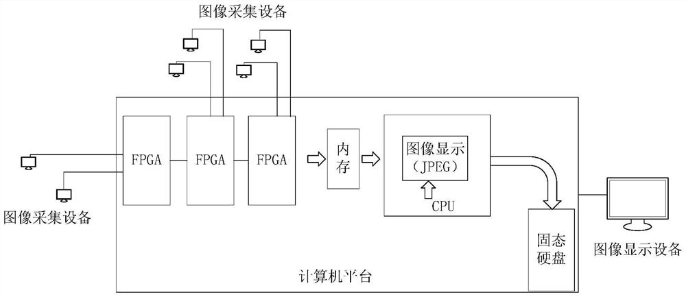
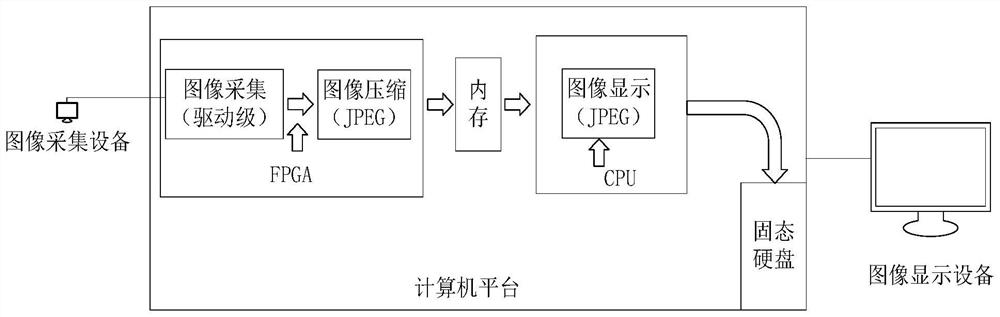
[0066] refer to figure 1 As shown, the embodiment of the present invention provides a system for real-time acquisition of map image data, and the system includes: an image acquisition device, an FPGA, and a CPU. Wherein, each CPU is connected to at least one FPGA, and each FPGA is connected to at least one image acquisition device;

[0067] Image acquisition equipment, used to collect geographical environment images and send them to FPGA;

[0068] The FPGA is used to receive in parallel the geographical environment image sent by the connected image acquisition device, perform color mixing and interpolation processing on the geographical environment image to obtain image data in RGB format, perform color space conversion on the image data in RGB format to obtain image data in YUV format and Split-channel output, data compression is performed on the image data of each channel in turn, and the compressed image data is transmitted to the memory;

[0069] The CPU is used to store...

Embodiment 2

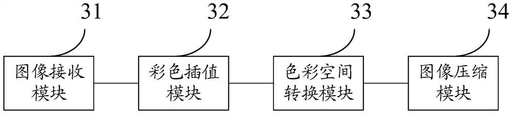
[0139] The second embodiment of the present invention describes the structure and connection relationship of the internal units in each module of the FPGA in the first embodiment, referring to Figure 6 ~ Figure 10 shown.

[0140] The image receiving module 31 is used to receive the geographical environment image collected by the image acquisition device, and transmit the geographical environment image to the color interpolation module 32 for subsequent processing. Such as Image 6 As shown, the image receiving module 31 includes a grayscale camera, a sample rate converter (Sample Rate Convertor, SRC), a Fifo memory, a Dn2 unit, etc., that is, Image 6 Contents within the dotted box. Among them, the grayscale camera is used to receive the geographical environment image sent by the image acquisition equipment, the SRC is used to convert the sampling frequency of the data, the Fifo memory can meet the collection, processing and transmission of high-speed data, and the Dn2 unit...


PUM


Abstract

The invention discloses a real-time acquisition system for map image data. The real-time acquisition system comprises a CPU, at least one FPGA connected with each CPU, and at least one image acquisition device connected with each FPGA; the image acquisition device is used for acquiring geographic environment images and sending the geographic environment images to the FPGA; the FPGA is used for receiving the geographical environment images sent by the connected image acquisition device in parallel, performing color mixing interpolation processing on the geographical environment images to obtain image data in an RGB format, performing color space conversion on the image data in the RGB format to obtain image data in a YUV format, outputting the image data in the YUV format in different channels, performing data compression on the image data in each channel in sequence, and transmitting the compressed image data to a memory; and the CPU is used for storing the compressed image data in the memory into the memory in real time. According to the scheme, real-time compression of the image data is realized, and the stability of data storage is improved.

Description

technical field [0001] The invention relates to the field of map technology, in particular to a system and method for acquiring map image data. Background technique [0002] In order to make a more accurate map, it is necessary to obtain as much and comprehensive image data as possible during the data collection stage. Therefore, high-precision map collection vehicles often install multiple image collection devices for data collection. When a large amount of original image data is collected, the original image data needs to be compressed for storage. In terms of the performance of most CPUs at present, it is still impossible to compress a large amount of original image data in real time. If the image data is compressed in real time, the CPU load will often be too high, which will affect the subsequent data processing process. [0003] At present, in order to solve the above problems, the common methods mainly include the following: [0004] 1. Set up two CPUs on the high-p...

Claims


Application Information

Patent Timeline
IPC IPC(8): H04N7/18H04N9/04H04N19/625H04N19/124H04N19/91G06T1/20
CPCH04N7/181H04N19/625H04N19/124H04N19/91G06T1/20G06T2200/28H04N23/843
Inventor 朱宝伟陈岳
Owner ALIBABA GRP HLDG LTD
Why Eureka
Try Eureka