A geothermal anomaly region extraction method based on multi-scale information fusion

An extraction method and abnormal area technology, applied in the field of remote sensing, can solve the problems of lack of thermal infrared data verification, omission of geothermal abnormal areas, etc., to achieve the effect of full utilization of resources

Active Publication Date: 2022-01-21
QINGDAO PROSPECTING INST OF GEOLOGICAL ENG
View PDF11 Cites 0 Cited by
  • Summary
  • Abstract
  • Description
  • Claims
  • Application Information

AI Technical Summary

Problems solved by technology

The most commonly used method for extracting temperature anomalies is the global threshold. Although this method is simple and fast, it may ignore some local high temperature anomalies and cause some geothermal anomalies to be missed.
After extracting temperature anomalies, geological faults and known prior knowledge are often combined to determine the final geothermal area, because geothermal heat is often distributed along the fault line, but it lacks higher-resolution thermal infrared data for verification, and for Refined extraction of some typical exceptions

Method used


Image

  • A geothermal anomaly region extraction method based on multi-scale information fusion
  • A geothermal anomaly region extraction method based on multi-scale information fusion
  • A geothermal anomaly region extraction method based on multi-scale information fusion

Examples


Embodiment Construction

[0040] The technical solutions of the present invention will be further described below in conjunction with the accompanying drawings and embodiments.

[0041] In this example, the Landsat-8 satellite data obtained in two periods were selected for experimentation. The research area is the entire Qingdao city. The spatial resolution of the multispectral image is 30 meters, and the spatial resolution of the thermal infrared band is 100 meters. The acquisition time is 2017. February 11, 2019 and August 28, 2019.

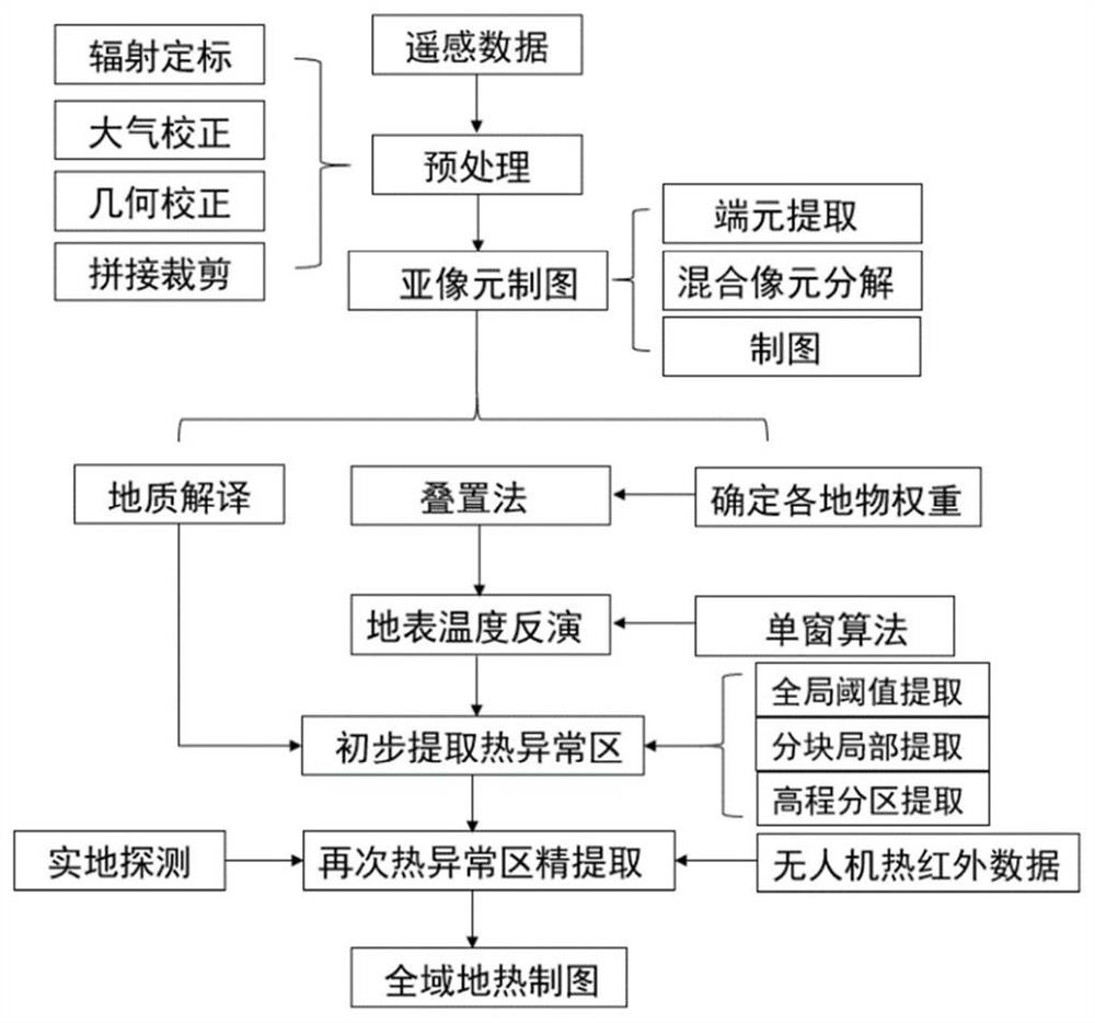
[0042] The geothermal anomaly area extraction method of multi-scale information fusion described in the present invention, such as figure 1 As shown, the steps are as follows:

[0043] Step 1: Acquire images and image preprocessing. In order to reduce the influence of the relative results at different times, firstly, the remote sensing images of the study area in different periods (Qingdao City in summer and winter) were obtained and radiometric calibration, atmospher...


PUM


Abstract

The invention discloses a geothermal anomaly region extraction method based on multi-scale information fusion. Firstly, the spatial resolution of the thermal infrared band in the satellite image is improved by using the fully constrained least squares mixed pixel decomposition and the sub-pixel spatial gravity model. Algorithm inversion obtains high-resolution temperature information. Then comprehensively extract the temperature anomalies in the study area from a global and local perspective, and delineate the range of geothermal anomalies by combining geological data and known prior knowledge, and verify the reliability of the results by expanding the study area based on multiple known hot spring locations sex. Finally, in some typical geothermal anomaly areas such as known hot spring locations, high-resolution UAV data are used for further fine extraction. The invention realizes the extraction of geothermal anomalies from coarse to fine, provides reference value for later manual mining, and realizes full utilization of resources.

Description

technical field [0001] The invention relates to the field of remote sensing, in particular to a method for detecting multiple geothermal anomalies in remote sensing images, and in particular to a method for delineating multi-scale geothermal anomalies from coarse to fine based on satellite images and UAV images. Background technique [0002] Geothermal energy is a cheap energy source endowed by the earth to human beings. An effective method for regional geothermal surveys is thermal infrared remote sensing. Therefore, thermal infrared remote sensing data are often used to extract geothermal anomalies. The traditional method is to use geophysical and chemical prospecting for geothermal detection, but this method is time-consuming, laborious and inefficient. Later, due to the deepening of the research on remote sensing technology, a variety of algorithms for obtaining surface temperature using thermal infrared remote sensing data were developed. Therefore, the method of combi...

Claims


Application Information

Patent Timeline
Patent Type & Authority Patents(China)
IPC IPC(8): G06T7/00G06T7/10G06T7/136G06T3/40
CPCG06T7/0002G06T7/10G06T7/136G06T3/4053G06T2207/10048G06T2207/10032
Inventor 付佳妮管勇何鹏徐美君董杰解永健赵锋徐锐
Owner QINGDAO PROSPECTING INST OF GEOLOGICAL ENG
Why Eureka
Try Eureka