Three-dimensional space situation characterization method and device of height information enhanced Mercator map

A Mercator projection and map technology, which is applied in the field of three-dimensional spatial situation representation of height information-enhanced Mercator maps, can solve the problems of frequent switching of viewing angles, decreased intuition, poor applicability, etc. good effect

Active Publication Date: 2021-06-18
NAT UNIV OF DEFENSE TECH
View PDF6 Cites 2 Cited by
  • Summary
  • Abstract
  • Description
  • Claims
  • Application Information

AI Technical Summary

Problems solved by technology

Although this form of expression can intuitively represent the three-dimensional space movement of spatial entities and the relationship between entities with close spatial positions, it has the following disadvantages: since the earth is located in the center of the field of view and often occupies a large proportion of the field of view, the field of view In the field, there are often situations where the object of interest is blocked by the earth, and the viewing angle needs to be switched frequently; it is impossible to intuitively express the relationship between multiple spatial entities with large longitude intervals in the same field of view; because the commonly used The parameter is latitude and longitude, which is a non-linear relationship with the spatial rectangular coordinates. When the traditional three-dimensional situation shows the relationship between the space entity and the ground entity, it will bring additional thinking and thinking transformation to the observer, and the intuitiveness of the performance will be reduced.
Since this form of expression does not introduce height information, it can only display the change of the spatial entity with the latitude and longitude. When the latitude and longitude of the two spatial entities are similar but the height difference is large, it will give people the illusion that they are very close, which is not conducive to the observer to accurately grasp the space. situational information
[0005] Therefore, the prior art has the problem of poor applicability

Method used


Image

  • Three-dimensional space situation characterization method and device of height information enhanced Mercator map
  • Three-dimensional space situation characterization method and device of height information enhanced Mercator map
  • Three-dimensional space situation characterization method and device of height information enhanced Mercator map

Examples


Embodiment approach

[0086] 1. Basic situation of the scene

[0087] a) Simulation time: Beijing time 2021-01-01 12:00:00.00;

[0088] b) Geosynchronous orbit satellite 1, the position coordinates of the ground-fixed system are (-17820230.95, 38215608.59, 0.00), and the half angle of the cone is 30.00°;

[0089] c) Geosynchronous orbit satellite 2, the position coordinates of the ground-fixed system are (-37570411.59, 19143080.85, 0.00);

[0090] d) Geosynchronous orbit satellite 3, the position coordinates of the ground-fixed system are (42166258.68, 0.00, 0.00);

[0091] e) Ground station 1, the deployment location is 30.00° east longitude, 15.00° south latitude, the operating distance is 5000.00km, and the half angle of the cone is 45.00°.

[0092] 2. The specific implementation method is as follows:

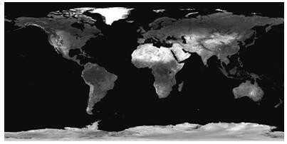
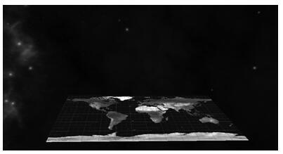
[0093] 1) Take the Mercator projection map as the XY plane base map, the zero longitude point on the equator as the coordinate origin O, the east longitude direction as the positive direction ...


PUM


Abstract

The invention relates to a three-dimensional space situation representation method and device of a height information enhanced Mercator map, computer equipment and a storage medium. The method comprises the following steps: by acquiring Mercator projection map data, establishing a longitude and latitude high-altitude isometric projection rectangular coordinate system by taking a Mercator projection map as an XY plane, forming a space situation three-dimensional representation space, directly acquiring or calculating through a preset formula to obtain a longitude value, a latitude value and a height value of a to-be-represented object in a geographic coordinate system; and obtaining an isometric projection coordinate value in the longitude direction and an isometric projection coordinate value in the latitude direction of the to-be-represented object in the longitude and latitude high-altitude projection rectangular coordinate system through a preset conversion relation, setting a height value, and drawing the to-be-represented object in the spatial situation three-dimensional representation space by adopting a visualization technology. According to the method, the distance relation illusion between the spacecrafts caused by height loss can be avoided, and particularly, the method has a very good effect in the aspect of representing the relation between the synchronous orbit spacecrafts and the spacecraft ground.

Description

technical field [0001] The present application relates to the technical field of three-dimensional representation of space situation, in particular to a method, device, computer equipment and storage medium for three-dimensional space situation representation of height information enhanced Mercator map. Background technique [0002] The space situation involves space moving entities such as artificial satellites, the sun, and the moon, ground entities such as measurement and control stations, ships, and vehicles, air moving entities such as aircraft, and the spatial geometric relationship and changes between entities. Since the movement scales of artificial satellites, the sun, and the moon are much larger than the scope of human naked eye observation, choosing an appropriate coordinate system and projection relationship, and visually displaying the entities involved in the space situation and their relationships through computer visualization technology are crucial to the de...

Claims


Application Information

Patent Timeline
Patent Type & Authority Applications(China)
IPC IPC(8): G06T17/05G06T3/00G06F16/29
CPCG06T3/005G06T17/05G06F16/29
Inventor 罗亚中张进李海阳周剑勇王浩然杨震黎克波
Owner NAT UNIV OF DEFENSE TECH
Why Eureka
Try Eureka