Unmanned aerial vehicle inspection method and device and edge calculation module
An edge computing and unmanned aerial vehicle technology, applied in three-dimensional position/course control, vehicle position/route/height control, non-electric variable control, etc. The problem is not high, to achieve the effect of clear target image
- Summary
- Abstract
- Description
- Claims
- Application Information
AI Technical Summary
Problems solved by technology
Method used
Image
Examples
Embodiment Construction
[0036] Exemplary embodiments of the present disclosure will be described in more detail below with reference to the accompanying drawings. Although exemplary embodiments of the present disclosure are shown in the drawings, it should be understood that the present disclosure may be embodied in various forms and should not be limited by the embodiments set forth herein. Rather, these embodiments are provided for more thorough understanding of the present disclosure and to fully convey the scope of the present disclosure to those skilled in the art.
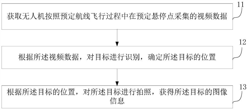
[0037] Such as figure 1 As shown, the embodiment of the present invention proposes a drone inspection method, which is applied to the edge computing module, and the method includes:
[0038] Step 11, obtaining the video data collected by the unmanned aerial vehicle at a predetermined hovering point during the flight of the drone according to the predetermined route;
[0039] Step 12, identifying the target according to the video d...
PUM
 Abstract
Description
Claims
Application Information
 - R&D
- Intellectual Property
- Life Sciences
- Materials
- Tech Scout
- Unparalleled Data Quality
- Higher Quality Content
- 60% Fewer Hallucinations
Browse by: Latest US Patents, China's latest patents, Technical Efficacy Thesaurus, Application Domain, Technology Topic, Popular Technical Reports.
© 2025 PatSnap. All rights reserved.Legal|Privacy policy|Modern Slavery Act Transparency Statement|Sitemap|About US| Contact US: help@patsnap.com


