Geological disaster hidden danger detection method for multi-unmanned aerial vehicle cooperative photogrammetry

A technology of geological disasters and multi-UAVs, applied in photogrammetry/video metrology, measuring devices, genetic rules, etc., can solve problems such as heavy workload and low efficiency, and achieve the effect of promoting technological development

Active Publication Date: 2021-06-08
四川融鑫信息科技有限公司
View PDF15 Cites 5 Cited by
  • Summary
  • Abstract
  • Description
  • Claims
  • Application Information

AI Technical Summary

Problems solved by technology

[0007] In addition, the traditional research and judgment of hidden dangers of geological disasters mainly relies on professionals to manually identify massive monitoring images, which has a large workload and relatively low efficiency

Method used


Image

  • Geological disaster hidden danger detection method for multi-unmanned aerial vehicle cooperative photogrammetry
  • Geological disaster hidden danger detection method for multi-unmanned aerial vehicle cooperative photogrammetry
  • Geological disaster hidden danger detection method for multi-unmanned aerial vehicle cooperative photogrammetry

Examples


Embodiment

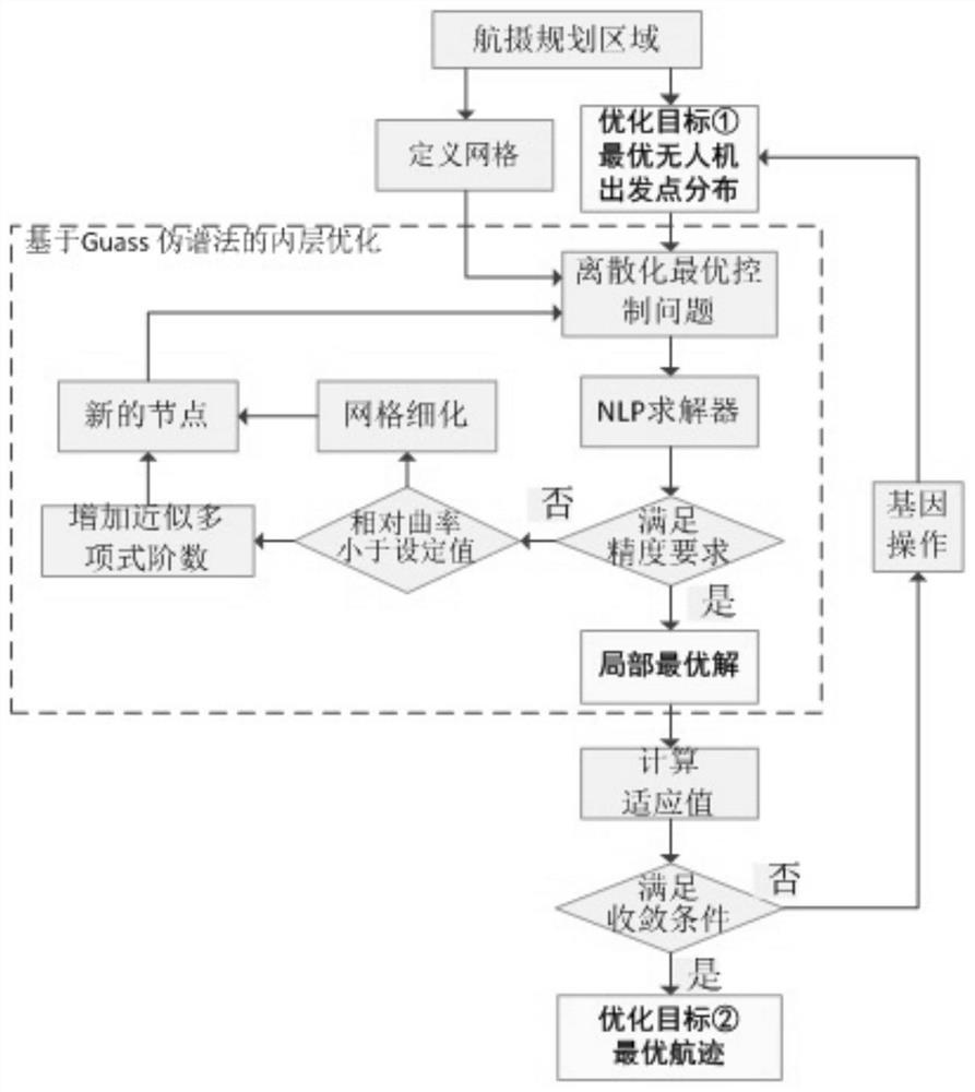
[0052] This embodiment proposes a method for detecting hidden dangers of geological disasters oriented to multi-UAV cooperative photogrammetry, the flow chart of which is shown in figure 1 , wherein the method includes the following steps:

[0053] S1. Determine the shape of the area to be detected;

[0054] S2. Calculate the multi-UAV collaborative photogrammetry track planning route according to the shape of the area to be detected;

[0055] S3. Multiple UAVs simultaneously collect multi-temporal and spatial-scale panoramic images on the planned route and stitch them together;

[0056] S4. Generate a high-precision digital elevation model and an ortho image according to the stitched panoramic image;

[0057] S5. Automatically identify and classify the hidden danger points of geological disasters, and automatically identify the small deformation of the ground in the area with hidden dangers of geological disasters;

[0058] S6. Using the identified micro-deformation of the...


PUM


Abstract

The invention relates to the field of geological disaster hidden danger detection, and provides a geological disaster hidden danger detection method for multi-unmanned aerial vehicle collaborative photogrammetry, and the method comprises the steps: firstly, judging the shape of a to-be-detected region; secondly, according to the shape of the to-be-detected region, calculating a multi-unmanned aerial vehicle cooperative photogrammetry flight path planning route; then, enabling the multiple unmanned aerial vehicles to simultaneously collect multi-temporal-spatial-scale panoramic images on the planned route and splice the multi-temporal-spatial-scale panoramic images; then, generating a high-precision digital elevation model and an orthographic image according to the spliced panoramic image; then, automatically recognizing and classifying geological disaster hidden danger points, and automatically recogizing ground tiny deformation in areas with the geological disaster hidden danger points; and finally, performing geological disaster early warning by using the identified ground tiny deformation. According to the invention, rapid generation of unmanned aerial vehicle digital images can be realized, integrated geological disaster detection is achieved, and technical development in the field of geological disaster detection is promoted.

Description

technical field [0001] The invention relates to the field of hidden danger detection of geological disasters, in particular to a hidden danger detection method for geological disasters oriented to multi-UAV collaborative photogrammetry. Background technique [0002] UAV coverage path planning (Coverage Path Planning, CPP) is defined as: under the premise of satisfying some (some) performance indicators, avoid obstacles and threat sources, and plan a path that can traverse the area to be covered. optimal flight route. In the field of robotics, this technology is called a coverage path planning (Coverage Path Planning, CPP) technology. [0003] Overlay trajectory planning is different from conventional trajectory planning. Trajectory planning in the traditional sense refers to point-to-point trajectory planning, which is defined as: in a certain environment, looking for UAVs to meet certain (certain) performance indicators from the starting point to the target point, avoidin...

Claims


Application Information

Patent Timeline
IPC IPC(8): G01C11/00G01C21/00G06K9/00G06K9/46G06N3/12G06T3/40G06T5/50G06T7/10
CPCG01C11/00G01C21/00G06N3/126G06T3/4038G06T7/10G06T5/50G06T2207/20221G06V20/13G06V10/462Y02T10/40
Inventor 李孝斌
Owner 四川融鑫信息科技有限公司
Why Eureka
Try Eureka